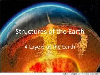
STRUCTURES AND COMPOSITION OF THE EARTH
300 likes | 436 Vues
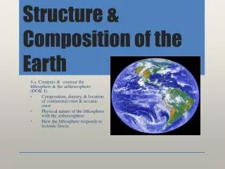
This article explores the Earth's structure, divided into three major layers: the Crust, Mantle, and Core. The Crust, composed of granitic and basaltic rocks, is a thin, weathered layer containing various elements like oxygen and silicon. The Mantle lies beneath, characterized by dense silicate materials and plastic zones that facilitate geological activities. Finally, the Core, composed of iron and nickel, encompasses an outer liquid and inner solid layer, with extreme temperatures. We also discuss land features such as mountains and volcanoes, highlighting their origins and types.

STRUCTURES AND COMPOSITION OF THE EARTH
E N D
Presentation Transcript
STRUCTURES AND COMPOSITION OF THE EARTH
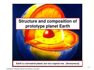
Three major divisions of the Earth: • Crust – this is the upper layer of the solid portion of the earth. This portion is composed of rock with a thin weathered upper layer which we call coil. It is estimated to be 20 miles deep and constitute about ½% of the earth radius. This upper layer maybe subdivided into sub – layers. • ►sial – is composed of granitic rocks mostly of • silicon and aluminum, and • ►sima – predominantly of basaltic rocks of silicon • and magnesium. The crust appears to be a thin • shell when viewed to scales with the rest of the • lithosphere.
An analysis of the composition of this layer showed that it contains 92 naturally appearing elements combined with each other forming compounds. These elements are distributed as follows: Oxygen 46.7% Calcium 3.7% Silicon 27.7% Sodium 2.8% Aluminum 8.0% Potassium 2.6% Iron 5.0% Others 3.5% At the base of the crust is the Mohorovivic discontinuity which separates the crust from the underlying layers. The rocks above this discontinuity have a specific gravity of 3.0 while those below it have a specific gravity of 3.3.
2. Mantle – is the layer just below the Mohorovivic discontinuity which extends to a depth of 1,800 miles below the earth’s surface. Studies have inferred that this region is the dense arrangement of silicate materials that are dark – colored originating from rocks of ocean and old mountain zone regions. Studies made on this layer through seismic readings indicate the presence of plastic zones responsible for: ►lava formation by converting sold mantle material into liquid rock material. ►furcating continents ►rising and sinking of portions of continents; and ►the breaking up and drifting of the continents;
3. Core or Nucleus – is that part of the earth which has a diameter of about 4,300 mile, more than ½ the total diameter of the earth. Through the seismic readings this layer is believed to be composed of an outer layer and inner solid part. Temperature and pressure rises as we go deeper into the core of the earth. The inner core is estimated to have a temperature of about 40,000 to 90,000 0F. Studies suggest that the core of the earth contains iron and nickel due to the following: ►Certain meteorites are composed of iron and nickel which may have the same origin as the earth. ►The magnetic field of the earth can be explained if the field originates from movement in a current conducting liquid core. ►The estimated specific gravity for about 9.4 to 15 is a result of denser packed iron and nickel.
Land Features of the Earth’s crust • 1. Mountains. Are regions of undisturbed or deformed rocks with steep slopes and considerable heights. • Types and origin of mountains: • ►Erosional mountains – are remnant landscapes formed • by selective erosion by streams or glaciers. • ►Folded mountains – are formed by a sidewise pressure • which causes the earth’s crust to fold or bend upwards for • thousands of meters. • ►Fault or Block mountains – are lifted upwards or titled at • different angles when large block if rocks move along • cracks. • ►Volcanic mountains – form as a result of extrusive • igneous activity. • ►Complex mountains – are mountain ranges formed by • the combination of faulting, folding and volcanic action.
Mount Mckinley Mammoth Mountain
2. Volcanoes and Earthquake Volcanoes are opening on the earth’s surface where molten materials, gases and solids come out. It builds up different features on the earth’s surface. Plenty of steam and gases like carbon dioxide, hydrogen, hydrochloric acid, hydrogen sulfide and sulfur dioxide are shoot out. Types of Volcanoes: Volcanoes may be classified according to eruption and activity. According to eruption, the types of volcanoes are: ►Explosive volcanoes – throw out violently big amounts of lava, gases and steam through the opening of the crater. ►Quiet volcanoes – the molten lava flows without violent reactions, builds a gently sloping lava cone and produces little gas or solid materials. ►Intermediate volcanoes – sometimes erupts violently but sometimes just give out lava quietly. ►Fissure eruptions – quiet lava flows out not only from craters but also along crustal cracks or fissures and forms lava plains or plateaus.
According to activity the types of volcanoes are: ►Active volcanoes – they show signs of eruption or are known to have erupted within the recent past and has the probability of erupting again. Examples: Taal, Mayon, hobok-hibok, Canlaon and Bulusan in the Philippines. Paricutin in Mexico; Vesuvius in Italy; Mauna Loa in Hawaii; and Lassa in California. ►Dormant volcanoes – show sign of activity but have not erupted fro several centuries. Examples: Mounts Arayat, Banahaw, Makiling and San Cristobal in the Philippines; Mt. Rainer in Washington D.C., USA. ►Extinct volcanoes – do not show signs of activity and not have erupted since recorded history. Their forms are being changed by weathering and erosion. Mt. Makiling in Laguna; Biliran in Leyte; Malindig in Marinduque are not completely extinct Volcanoes for there may be no completely extinct volcanoes. They just omit very hot water and mud which are continuously bubbling and gushing out of many openings.
ACTIVE VOLCANOES TAAL MAYON VESUVIUS
DORMANT VOLCANOES MOUNT MAKILING MOUNT ARAYAT MOUNT RAINER
Volcanoes in the Philippines The Philippines has many volcanoes. Volcanic cones hot on the land from Batanes to Sulu. They throw ashes, gases and big solids. Though they have destroyed plenty of lives and property, people who live in volcanic areas are reluctant to leave because of rich harvest they reap from the soil made of weathered volcanic materials. At present there are 46 recorded volcanoes in the Philippines, 13 are active and the rest are dormant. The active volcanoes are: Mayon in Albay Taal in Batangas Bulusan in Sorsogon Canlaon in Negros Oriental Hibok-hibok in Camiguin Banahaw in Laguna Musuan in Valencia Smith in Babuyan Island Sto.Tomas in Benguet Didicas in Babuyan Island Makaturing in Lanao del Sur Pinatubo in Zambales Babuyan Claro in Cagayan These volcanoes are neither wholly of the “explosive” type nor wholly of the “quite” type but have eruptions in which both lava flows and explosions figure dominantly.
Mt. Canlaon Hibok-Hibok Pinatubo Taal
Why Volcanoes Erupt – Volcanoes act as “safety valves” in the earth’s crust are pockets of magma. When its pressure builds up to a certain point that can force upon the rocks that lie over them; the volcano erupts. Eruptions continues until the pressure becomes weak and the volcanoes become quite. As long as there is enough heat and pressure volcanoes erupt. As previously mentioned; geologists believe that great internal pressure cause heat. Recently, radioactivity was discovered to produce heat when radioactive elements disintegrate and transmulate into other substances. It is said that radioactive changes that take place within the earth can produce enough as long as there is enough pressure inside the magma pocket to force out volcanic.
Types of natural earthquake are classified as tectonic, volcanic, and plutonic, according to the origin of disturbance: • ►Tectonic earthquakes – are due to sudden displacement • of the earth’s crust along a line weakness or fault. • ►Plutonic or deep- seated – are those that have the same • cause as tectonic or normal with the foci reaching as deep • as 500km. Most Philippine earthquakes are tectonic in • origin. • ►Volcanic earthquakes occur when volcanoes become • active. Plutonic earthquake are better recognized by • seismograph. • Artificial earthquakes are caused by activities of man.
Earthquakes intensity and magnitude. Earthquake are described by the destruction caused and energy released. Scales have been made to describe the effects observed. They include sound, visible and felt vibration, type and severity of damage. Different scales are used in different places such as: For instance, in the United States, the Modified Mercalli Scale is used. In Europe, the Rossi – Forel from which the modified Mercalli scale was developed, is used. In Japan, the Japan Meteorological Scale is used. Earthquake intensity mainly on the distance between the observer and the epicenter or place of the earth’s surface directly above the focus, the point where damage is maximum. Charles Richer developed a scale for determining the magnitude of an earthquake. A magnitude is the amount of energy released by an earthquake and is determined by instrumental measurements, unlike intensity, which can be made by subjected observations. Earthquake magnitudes may be a little over zero but not more than 8. If the magnitude is 8, it is 108 times as strong as the smallest earthquake, in terms of energy released.
The following is the Rossi – Forel Scale of Earthquake Intensities (Adapted to the Philippines by Rev.W.C. Reptti) ► Hardly perceptible Shock: felt only by an experienced observer under the favorable condition. ► Extremely Feeble Shock: Felt by small number of persons at rest ► Very Feeble Shock: Felt by small number of persons at rest. Duration and direction maybe perceptible. Sometimes dizziness or nausea experience. ► Feeble Shock Felt generally indoors, outdoors by few. Hanging objects swing slightly. Creaking of frames of houses. ► Shock of moderate intensity: Felt generally by everyone. Hanging objects swing freely. Overturn of all vases and unstable objects light sleepers awaken. ► Fairly Strong Shock – General awakening of those asleep. Some frightened persons leave their houses. Stopping of pendulum clocks. Oscillation of hanging lamps. Slight damage in very old or poorly built structure. ► Strong Shock – over turn of movable objects. General alarm, considerable in old or poorly built structures, old walls, etc. Some landslides from hills and steep bank. Cracks in roads surfaces. ► Very Strong Shock – People panicly. Tress shaken strongly. Changes in the flow of springs and wells. Sand and mud objected from fissures in soft ground. Small landslides. ► Extremely Strong Shock – General panic. Partial or total destruction of some buildings. Fissures in ground. Landslide and rocks falls.
Destruction brought about by earthquake: Tsunami and Fires Tsunamis or seismic waves are waves caused by earthquakes. They are popularly called tidal waves although they are not related to tides. They are brought about by the up an down of down movements of rocks or by sliding mud under the sea or by huge volcanic eruptions materials to the surface. Dropping even the biggest bombs can only change the direction of flow of lava but cannot affect the eruption.
How Volcanoes are Distributed – Volcanoes are found in definite belts on the earth’s surface. As they are related to earthquakes, volcanic belts are also earthquake belts, and belts of young, growing mountains. It is believed that volcanic belts shows margins of very large, slowly moving earthquake slabs of the lithosphere. The volcanic belts are the following: ►The Circum Pacific Belt which is the major volcanic belt that border the sides of the Pacific Ocean. Its major volcanoes are in the Philippines, Japan, Aleutian Islands, Alaska, South American Andes, Hawaiian Islands and New Zealand. ►The Meditteranean belt which parallel to and boarders the Mediterranean Sea. It includes the Alps. Asia Minor, and the Himalayas eastward to the Indonesian states. ►The third volcanic belt which is submerged along the system of the mind – ocean ridges where many small volcanoes are arranged in line with crustal fractures.
Life History of Volcanoes Like mountains and rivers, volcanoes pass through a life history in which the volcano is tall straight. Erosion does not have a chance yet to do its work. All active volcanoes and extinct volcanoes which have not been affected yet by erosion are young. Examples are Mayon and Mariveles. In Maturity, the volcano, now extinct, has gullies and valleys on its slopes due to erosions. Examples are Taal and Makiling in the Philippines and Mount Hood in the US. In old age, all that remains of the volcano is its core of more resistant rock, called the volcanic neck. Old aged volcanoes have necks like the Devil’s Towe in Wyoming and Mount Royal in Montreal Canada.
Earthquakes The shaking of the ground is called the earthquake. It may be too weak to be noticed or too strong to be destructive. Nobody feels the weak daily earthquakes. Relatively stronger ones are noticed by experienced observers and by recording instruments called seismographs. The most destructive ones destroy property and do all the things mentioned above. Why the earthquakes is not yet fully known, the seismologists suggests the “elastic rebound theory” to explain it. The theory says that the slowly builds up stress. When this goes beyond the breaking point of the rocks involved, they yield or break and everything around shakes. The great amount of energy released during an earthquake causes a series of tremors composed of one major shock followed by lesser ones called aftershock s. Sometimes foreshocks precede the big tremor. This means a slow build up strain energy in the earth before the earthquake. An earthquake may last only a few seconds or maybe as long as 75 seconds, as in San Francisco, California earthquake which reached its greatest intensity in 40 seconds, stopped for 5 to 10 seconds and went on stronger than the previous for about 25 seconds.
Seismologist suggest that minor earthquakes maybe caused by volcanic eruptions and underground shifting of magma and that major ones are caused by the passage of a group of elastic waves produced by a quick movement of parts of the earth’s crusts and mantle along the fault surfaces. Classification of earthquakes as to depth: ►Shallow earthquake – originates from the crust and has depth of 0 -33 km. ►Intermediate earthquake – originates from the upper mantle and has a depth of 33 -300 km. ►Deep earthquake – originates from the lower mantle and has a depth of 300 – 700 km.
Big or small earthquakes occur in the crust, along fractures. Occasional earthquakes originate from the mantle. Where earthquakes happen, although they can occur anywhere, anytime, they are most common in belts. They swarm around regions where mountain building and crustal movement are active. Earthquakes and volcanoes occur in belts. The circum –pacific belt is composed of young mountains and chains of volcanic mountains. It extends from Chile along the Western borders of North and South America, Alaska, Japan, Philippines, Indonesia, New Zealand and some other Pacific Islands. The other earthquake belt, the Mediterranean and trans-Atlantic belt, includes the Carribean area through the Himalayas, the Alps, Spain Italy, Greece and Norhtern India. About 80% of earthquakes come from circum –pacific belt, 15% from the Mediterranean and Trans – Atlantic and 5% from other parts of the earth. In the Philippines, which is in the circum-Pacific belt, earthquakes swarm in the eastern part, along the western Pacific Ocean, where young mountains and volcanoes are commonly found.