Download

1 / 43
430 likes | 553 Vues
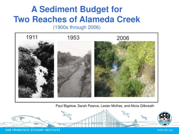
A Sediment Budget for Two Reaches of Alameda Creek (1900s through 2006). Paul Bigelow, Sarah Pearce, Lester McKee, and Alicia Gilbreath. Study Questions. Are the study reaches supplying a major source of sediment to the flood control channel?

E N D
A Sediment Budget for Two Reaches of Alameda Creek (1900s through 2006) Paul Bigelow, Sarah Pearce, Lester McKee, and Alicia Gilbreath
Study Questions • Are the study reaches supplying a major source of sediment to the flood control channel? • What are the dominant processes, and what are the rates of erosion and amount of storage? • What proportion of total sediment load at Niles is derived from the study reaches? • How has the channel changed through time?
Brief Watershed History Pre-1900: channel ditching, groundwater wells, small dams 1900: Ditching and draining of Tulare Lake 1911: ADLL incision rate of 6 in/yr
1925: Calaveras Dam, gravel mining 1950s: Four largest flood events on record 1964: San Antonio Dam 1968: Del Valle Dam 1970s: Flood Control Channel construction 1980s to 2000s: Flood Control Channel dredging Oblique view of Pleasanton and Dublin (looking west) during the 1955 flood
Arroyo De La Laguna Lower Subreach Upper Subreach
Sediment Budget Methods • Incision – bed elevation surveys 1959, 1971, 2007 • Bank Erosion & Bar Storage – field surveys and air photo analysis • Cross Section Surveys – historical and current • Flood Plain Storage – field surveys • Only subset of data collected for Alameda Creek Reach (little incision, 90% of drainage area above dams)
Compare Reaches w/ Watershed +Verona Gage +Welch Gage +Study Reaches +Ungaged Tribs = Niles Gage? • Balance the Budget • Estimate Yield at Gages (rating curves) • Estimate Yield for Ungaged tributaries (reservoir sedimentation rate) • Compare Reaches w/ Niles Gage
Sediment Budget Periods • 1901 – 1959 • 1959 – 1971 • 1971 – 1993 • 1993 – 2006
ResultsLong Profiles Arroyo De La Laguna Bed Elevation ~1901 – 1959 4.5 m ave total incision depth 6 – 10 cm/yr
1959 to 1971 Bed Elevation 1-2 m incision depth 7 – 15 cm/yr
1971 to 2007 Bed Elevation 0.5 – 0.8 m incision 2 – 6 cm/yr 0.75 m aggradation
Bank Erosion & Bar Storage Aerial Photograph Analysis • Assessed entire study reach • Focused on four locations • Four time periods • Quantified bank erosion and bar storage
Location C 1939-1950 1950-1966 1966-1993 1993-2005 Retreat rate 0.0 m/yr Retreat rate 0.9 m/yr Retreat rate 0.6 m/yr Retreat rate 3.8 m/yr 2005 Photo
Channel Cross Sections 5-6 m 5-6 m
Overall Watershed Comparisonfor Recent Period (1994 – 2006) Within 5%
Sediment Budget Take Home Points • Sediment budget has adjusted over several periods of land use alteration and disturbance from floods • Budget dominated by incision in earlier periods, now adjusting through bank erosion • ADLL sediment yield is high for a short reach (0.25% of total stream network length) • But ADLL comprises a small portion of watershed sediment yield (6% of total yield)
Future Channel Evolution Channel Evolution Models • Process-based classification • Describe channel form as it responds to a disturbance • Shows typical channel adjustments to return a balance of sediment transport capacity
Future Response of ADLL Conceptual Scenarios:
Next Steps - Recommendations • Monitor future channel adjustment in ADLL, and continue to stabilize the reach • Given management changes on Alameda Creek, monitor future channel response for sediment supply increase • Conduct a phased watershed sediment budget • Phase 1: Quantitatively (on public lands) and qualitatively (on private lands) assess feasibly manageable sediment • Phase 2 (if needed): Quantitative evaluation of manageable sediment on private lands • Conduct numerical modeling to understand sediment routing to and deposition within the Flood Control Channel