Download
1 / 40
410 likes | 655 Vues
Introduction to the Dual-Polarized WSR-88D. Don Burgess OU CIMMS/NSSL (Ret.). Explaining Dual-Polarization. Dual-polarization radars emit EM waves with horizontal and vertical polarizations. - Alternating H & V Transmission requires an expensive fast switch and longer acquisition times.

E N D
Introduction to the Dual-Polarized WSR-88D Don Burgess OU CIMMS/NSSL (Ret.)
Explaining Dual-Polarization Dual-polarization radars emit EM waves with horizontalandvertical polarizations. - Alternating H & V Transmission requires an expensive fast switch and longer acquisition times
WSR-88D Dual-Polarization Upgrade • Simultaneous Transmission And Reception (STAR); Slant 45 • Transmit at 45o, receive at both horizontal and vertical • There is a PROBLEM!
WSR-88D Dual-Polarization Upgrade • Simultaneous Transmission And Reception (STAR); Slant 45 • Transmit at 45o, receive at both horizontal and vertical • There is a PROBLEM! Split the power; 3-dB sensitivity loss
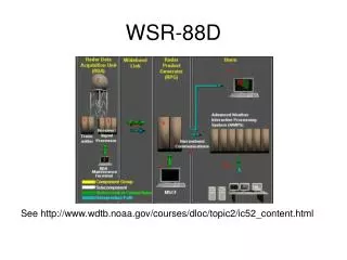
List of New WSR-88D Dual-Pol Outputs • 3 New Variables (like moments) • Differential Reflectivity (ZDR; Zdr) • Correlation Coefficient (CC; Rhv) • Specific Differential Phase (KDP; Kdp) • 3 New Algorithms • Melting Layer • Hydrometeor Classification • QPE • 9 NEW Precipitation Estimation Display Products
New Product #1: Differential Reflectivity (ZDR) Horizontal Reflectivity Vertical Reflectivity
ZDR Physical Interpretation Pv Pv Pv Ph Ph Ph Zh ~ Zv Zh > Zv Zh < Zv
Correlation Coefficient (CC) Typical Values Non-Precip Precip
Definition:gradient of the difference between phase shift in the horizontal and vertical directions Units:degrees per kilometer (o/km) New Product #3: Differential PhaseSpecific Differential Phase Shift (KDP) Differential phase shift
What ΦDP Means t6 ΦDP
KDP Has Big Advantages Gradients Most Important= KDP!!! Immune to partial beam blockage, attenuation, radar calibration, presence of hail Used primarily for rainfall estimation and locating heavy rain
Typical Values :: KDP • The main difference between ZH and KDP is that ZH gets contributions from all hydrometeors, including those comprised of ice, whereas KDP is not sensitive to ice particles. • Almost linearly related to rainfall rate • KDP is great at indicating high amounts of liquid precipitation
Melting Layer Detection Algorithm Run in the RPG Mixed phase hydrometeors: Easy detection for dual-pol! • Z typically increases (bright band) • ZDRand KDP definitely increase • Coexistence of ice and water will reduce the correlation coefficient (CC ~0.9-0.8) Algorithm overlay product for top and bottom of melting layer User Selectable MLDA, RUC, Sounding
Hydrometeor Classification Algorithm (HCA) Lgt/mod rain Heavy rain Hail “Big drops” Graupel Ice crystals Dry snow Wet snow Unknown AP or Clutter Biological Current Classification Options Run in RPG Algorithm makes best guess of dominant radar echo type for each gate • Display Product for each radar elevation angle Based on Fuzzy Logic Tornado debris category to be added
20000 ft MSL SOO-DOH Images\kcri_0.5_HC_20080408_0638.png
Hydrometeor Classification Algorithm Challenges • Run in the RPG • Verification Limitations: We need the A10 aircraft • “Fuzzy” Logic; assumes Zdr Accuracy • Typical Radar sampling limitations (snow at 2000 ft AGL may not be snow at the surface)
Dual-Pol QPE Algorithm Run in the RPG Uses Z, Zdr, Kdp 9 new products • Match Legacy PPS • Instantaneous Rate • User Selectable (Up to 10 durations) for the NWS • Difference products Legacy Products still available
WSR-88D Dual-Pol Calibration • Dual-Pol calibration is more complex than Legacy calibration • Zdr calibration • Initial System PHIdp calibration • Components/outputs are temperature sensitive • Initial system PHIdp calibration working well • Zdr calibration still under investigation • Full system calibration • Vertical pointing = NO • Cross-polar calibration = Not Yet • We think Zdr not calibrated to < 0.1 dB
“Investigate System ZDR” Basics • Part of “ZDR” comes from the system • Different losses in H & V transmit and receive paths • ZDRtrue = ZDRmeasured - ZDRsys • ZDRsys initially measured during off-line calibration, then adjusted for drift over time ZDRsys = Initial ZDRsys + drift compensation Updated each volume scan Offline calibration Retrace + 8 hr check
0.99<Rhv; Range: 20-60 km; Elevation: 2.4 deg; Height < 2.5 km 0.65 dB observed value Zdr sys error = .42 dB 0.23 dB expected value
0.99<Rhv; Range: 20-60 km; Elevation: 2.4 deg; Height < 2.5 km 0.45 dB observed value Zdr sys error = .22 dB 0.23 dB expected value
The WSR-88D Upgrade Deployment • All WSR-88Ds upgraded 2010-2012 = NO • 10-14 days radar downtime during upgrade • System Test: Apr 10 – Sep 10 • KOUN: April 2010 • Ops Test: Sep 10 – May 11 • Vance: Feb 2011 • Beta Test: Jun 11 – Aug 11 • Wichita: June 2011 • Phoenix: June 2011 • Pittsburgh: July 2011 • Morehead City: July 2011 • Full Deployment: Sep 2011 to Apr 2013
Sep 26, 2011 Legend Deployment Complete Deployment In Progress Deployment Scheduled Radar coverage shown is at 10,000 ft AGL or below
Jan 2, 2012 Legend Deployment Complete Deployment In Progress Deployment Scheduled Radar coverage shown is at 10,000 ft AGL or below
Jun 18, 2012 Legend Deployment Complete Deployment In Progress Deployment Scheduled Radar coverage shown is at 10,000 ft AGL or below
Dec 01, 2012 Legend Deployment Complete Deployment In Progress Deployment Scheduled Radar coverage shown is at 10,000 ft AGL or below
Apr 22, 2013 Legend Deployment Complete Deployment In Progress Deployment Scheduled Radar coverage shown is at 10,000 ft AGL or below
The Result for 5-CM & 3-CM • Scattering response different for • shorter wavelengths (above) • ZDR and KDP are different at the shorter wavelengths (right)
Summary • WSR-88D Dual-Pol deployment underway; lots of data in 2012 • More work needed on dp calibration and dp algorithms • Some model verification work with dp data can be done soon • Lots of model verification work with dp data can be done with time • How will dual-pol information be assimilated into models? • Assimilate dual-pol variables? • Assimilate dp algorithm output? • Drop size and ice distributions? • Something else?
Impacts of radar wavelength Fields of measured Z, ZDR, and ΦDP at C and S bands for the storm on 03/10/2009 at 0309 UTC. El(C) = 0.41°, El(S) = 0.48°. C-band radar is at X = 0, Y = 0. The areas of visible negative bias of Z caused by attenuation at C band are marked as A and B (left top panel). Taken from: Gu, et al. (conditionally accepted to JAMC)
Those Darn Laws of Physics Again • The Full Radar Equation is Ugly • Radar Scattering Cross-Section Equation is Ugly • We Simplify Things at 10-cm Wavelength • 10-cm: Rayleigh Approximation • Scattering by particles whose radii are ~1/10 of the radar wavelength or smaller • 5-cm & 3-cm we must use the full Mie Scattering Equation…the Ugly Equation
Important Information The fundamentals of this presentation and other Dual-Polarization training materials for outreach (NWS, media, others) are at: • http://www.wdtb.noaa.gov/modules/dualpol/index.htm