Download
1 / 21
210 likes | 429 Vues
The Association of the Elevated Mixed Layer with Significant Severe Weather Events in the Northeastern United States. By: Peter Banacos And Michael Ekster. What is Elevated Mixed Layer? (EML).

E N D
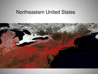
The Association of the Elevated Mixed Layer with Significant Severe Weather Events in the Northeastern United States By:Peter Banacos And Michael Ekster
What is Elevated Mixed Layer? (EML) • The horizontally advected hot, dry, and deeply mixed boundary layer air over areas of lower terrain. • Lies atop an interface of strong static stability, creating CIN • Similar to a “loaded gun” sounding. • Late spring / summer phenomenon
Why EML? • EML formation is well understood, however its movement, evolution, and inevitable dissipation has received less attention • Johns and Dorr (1996) • Farrell and Carlson (1989) • Solely focused on tornadoes and not derechos or large hail events • Performed prior to high-powered compositing techniques • This paper attempts to catalog significant severe weather • Hail >2 in. (5.1 cm) in diameter, • Convective wind gusts >65 kt (33 m s^-1) • Tornadoes of >F2 intensity
Lapse Rate Tendency Equation • A B C D E • A = Diabatic Heating Term, where a decrease (increase) in diabatic heating with height yields a steepening (lessening) lapse rate • B = Horizontal Lapse Rate Advection term • C = Vertical Lapse Rate Advection term • D = Differential Temperature Advection term, where a steepening (lessening) lapse rate would occur within a thermally indirect (direct) circulation • E = Vertical Stretching term.
As well as differential ageostrophic temperature advection being positive (downstream of amplifying baroclinic wave, jet entrance, or frontogenetic circulation)
Data and Methodology • 929 significant severe reports (3% of original 30,617 reports) • EML soundings were chosen based on: • An elevated lapse rate ≥ 8°C/km through a depth of 200 hPa or greater • An increase in environmental relative humidity with height from a minimum at the bottom of the layer of steep lapse rate, through the depth of the steep lapse rate layer • 34 significant severe weather days from 1970-2006 that met an “EML” criterion. • This accounted for only 0.1% of severe weather reports in the NE, but owed to 52.9% of fatalities and 45% of injury totals.
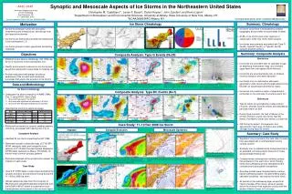
Data and Methodology • Constructed composite analyses of 700 hPa heights and temperatures,700-500 hPa lapse rates, LI, and MSLP. • Backward Lagrangian trajectories at 250 hPa AGL, and every km up to 6km for a duration of 96 hours.
Composite Analysis • 700 hPa height anomalies • EML events have a stronger northerly displaced ridge and heights anomalies of 36 m. • Placement of ridge and trough allow for a westerly geostrophic flow.
Composite Analysis • 700 hPa temperature anomalies • Positive anomaly maxima moves from central plains to the Northeast. • Anomalies of +3°-+3.5°C exist.
Composite Analysis • 750-500 hPa lapse rate • The EML composite mean value is 7.5°-8°C km • Anomalies are +1°C/km • Plume extends across Great Lakes region. • Important because EML plume shows steeper lapse rates.
Composite Analysis • LI and MSLP • MSLPs are similar in EML and non-EML cases • Illustrates importance of atmosphere aloft-EML Plume. • Greater potential instability in the EML composite.
Trajectory Analysis • Anticyclonic curvature • Consistent with the 700 hPa ridge • Most originate over the Intermountain West • Similar paths to 700 hPa temperature anomalies and 750-500 hPa lapse rate composites. • (b) represents 10 trajectories showing three-quarter or greater anticyclonic loops.
Trajectory Analysis • After t-51 h, parcel begins subsiding. • Dp/Dt shows subsidence 1-2 prior to event followed by accent. • Subsidence strengthens capping inversion • Maintains EML plume by not allowing DMC. • Vertical velocity switches sign at t-14 h. • Rising motion allows cap to weaken and DMC fires.
Case Studies • Eastern New York-western Massachusetts tornadoes: 28 August 1973 • 350 km swath of severe weather • Associated with an EML event
Case Studies • Northern New England and southern Quebec derecho: 5 July 1999
Conclusions: • Hypothesize V ∙ and ω > 0 within the EML plume are both essential for maintenance and transport over large distances. Release of instability over the NE is essential. • Mean 700hPa anticyclonic flow featured over Tennessee River valley. • 700hPa trough along the West Coast that results in ejection of the EML plume across the plains. • Anticyclonic flow across the plains, yielding mean ω > 0 and limited convection for plume maintenance until it moves downstream of the ridge axis. • Shortwave trough embedded in enhanced to moderately strong WNW mid-level flow across Great Lakes, which leads to entrained EML air, leading to convection and ω< 0