Clouds! By: Alexie Canik
170 likes | 391 Vues
Clouds! By: Alexie Canik. I Hope You Enjoy My Power Point! . Types of Clouds. Cirrus Cirrocumulus Cirrostratus Altocumulus Altostratus Stratus Stratocumulus Nimbostratus. Cumulus Cumulonimbus Lenticular Kelvin-Helmholtz Mammatus Contrails.

Clouds! By: Alexie Canik
E N D
Presentation Transcript
Clouds!By: AlexieCanik I Hope You Enjoy My Power Point!
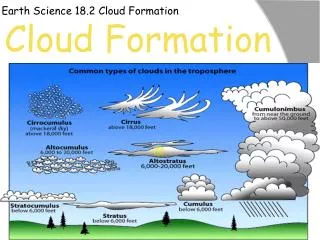
Types of Clouds • Cirrus • Cirrocumulus • Cirrostratus • Altocumulus • Altostratus • Stratus • Stratocumulus • Nimbostratus • Cumulus • Cumulonimbus • Lenticular • Kelvin-Helmholtz • Mammatus • Contrails
Cirrus Cloud Facts • Thin wispy clouds blown by high winds into long streamers. • Form above 6,000 m (20,000 ft) • Highest clouds. • Usually mean good weather
Cirrostratus Clouds • Often cover entire sky. • So thin, even sun & moon can be seen through them. • Thin, sheet like clouds.
Cirrocumulus Clouds • Appear as small, rounded white puffs of cloud. • The small ripples in cirrocumulus clouds sometimes resemble fish scales. • At times when there is a lot of cirrocumulus clouds, the sky is named “mackerel sky”
Stratus Clouds • Uniform gray clouds that often cover entire sky • Resemble fog that doesn’t reach the ground. • Usually no precipitation falls from stratus clouds, at times though, it may drizzle. • When thick fog “lifts” the resulting clouds are low stratus.
Nimbostratus Clouds • Dark gray, “wet” cloud, associated with continuously falling rain or snow. • Often produce precipitation that is unusually light to moderate.
Stratocumulus Clouds • Stratocumulus clouds generally appear as a low, lumpy layer of clouds that is sometimes accompanied by weak intensity precipitation. • Stratocumulus vary in color from dark gray to light gray and may appear as rounded masses, rolls, etc., with breaks of clear sky in between.
Cumulus Clouds • Puffy clouds that sometimes look like pieces of floating cotton. • These clouds grow upward, and they can develop into a giant cumulonimbus, which is a thunderstorm cloud.
Cumulonimbus Clouds These clouds are named because they are puffy ("cumulo") and because they often are dark clouds which cause rainstorms ("nimbus"). Cumulonimbus clouds are different because they cannot be classified as low, middle or high altitude clouds. These are often storm clouds which can be ten or more miles in height, extending through all the levels of altitude.
Lenticular Clouds Lenticular clouds, technically known as altocumulus standing lenticularis, are stationary lens-shaped clouds that form at high altitudes, normally aligned at right-angles to the wind direction. Where stable moist air flows over a mountain or a range of mountains, a series of large-scale standing waves may form on the downwind side. Lenticular clouds sometimes form at the crests of these waves.
Kelvin-Helmholtz Clouds These clouds are formed between two layers of air, with different densities, traveling at different speeds. Therefore, if a warm, less dense layer exists over a layer of colder, denser air, and the wind shear across the two layers is strong enough, eddies will develop along the boundary. Consequently, the clouds will take on a wave-like appearance
Mammatus Clouds Sometimes very ominous in appearance, mammatus clouds are harmless and do not mean that a tornado is about to form; a commonly held misconception. In fact, mammatus are usually seen after the worst of a thunderstorm has passed. As updrafts carry precipitation enriched air to the cloud top, upward momentum is lost and the air begins to spread out horizontally, becoming a part of the anvil cloud
Contrails Clouds The condensation trail emitted by jet aircraft exhaust are called contrails. Contrails form when hot humid air from jet exhaust mixes with environmental air of low vapor pressure and low temperature. Cloud formation by a mixing process is similar to the cloud you see when you exhale and "see your breath".
Resources.. • http://www.windows2universe.org/earth/Atmosphere/clouds/cloud_types.html • http://www.cityofportsmouth.com/school/dondero/msm/weather/cirrus.html • http://eo.ucar.edu/webweather/cirrus.html • http://ww2010.atmos.uiuc.edu/%28Gh%29/wwhlpr/stratocumulus.rxml • http://eo.ucar.edu/webweather/cumulus.html
Even More Resources.. • http://chalk.richmond.edu/education/projects/webunits/weather/cumulonimbus.html • http://www.crystalinks.com/lenticular.html • http://bobqat.com/Essays/Balloon/kelvin_helmholtz.html • http://ww2010.atmos.uiuc.edu/%28Gh%29/guides/mtr/cld/cldtyp/oth/mm.rxml
Jeez, Moooore Resources.. • http://cimss.ssec.wisc.edu/wxwise/contrail.html