Download
1 / 74
740 likes | 898 Vues
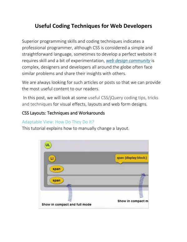
Visualization Techniques Useful For Planning - Ensley Township-. Visualization Techniques - Ensley Township. Project Funded by the Fremont Area Community Foundation Project Goal: To integrate existing geographic information into cohesive and useful land use decision-making tools

E N D
Visualization Techniques Useful For Planning - Ensley Township-
Visualization Techniques - Ensley Township Project Funded by the Fremont Area Community Foundation Project Goal: To integrate existing geographic information into cohesive and useful land use decision-making tools for practical application by local units of government
Visualization Techniques - Ensley Township • ArcGIS – ESRI, Inc • Scenario 360 / CommunityViz – Orton Family Foundation, Placeways • Impervious Surface Analysis Tool (ISAT) – NOAA • L –THIA (Long Term Hydrologic Impact Assessment) – Purdue University • Community Build-Out – Center of Rural Studies, Vermont • Population Allocation Model – AWRI • What if? – Community Analysis and Planning Systems (University of Akron Ohio) • SLUETH (Land Transformation Model) – University of Santa Barbara
Visualization Techniques - Ensley Township • ArcGIS – ESRI, Inc • Scenario 360 / CommunityViz – Orton Family Foundation, Placeways • Impervious Surface Analysis Tool (ISAT) – NOAA • L –THIA (Long Term Hydrologic Impact Assessment) – Purdue University • Community Build-Out – Center of Rural Studies, Vermont • Population Allocation Model – AWRI • What if? – Community Analysis and Planning Systems (University of Akron Ohio) • SLUETH (Land Transformation Model) – University of Santa Barbara
Visualization Techniques - Ensley Township Population Allocation Model • Population Growth Potential • Land Availability Index • Land Desirability Index
Visualization Techniques - Ensley Township Population Allocation Model • Population Growth Potential • Land Availability Index • Land Desirability Index
Population Change Source: US Census Bureau
Population Projections Using Mean Annual Growth Rate from 1990-2000 (2.58 percent)
Population Projections Using Mean Annual Growth Rate from 1960-2000 (4.16 percent)
Visualization Techniques - Ensley Township Population Allocation Model • Population Growth Potential • Land Availability Index • Land Desirability Index
Urban Sprawl Index for Selected Townships Note: An area is considered to be "sprawling" when the rate of land consumption exceeds the rate of population growth. This Urban Sprawl Index compares the relative amount of change in acreage used for development to the relative amount of change in population. The higher the index value the greater the "sprawl" in the Township. A value of 1 or less indicates no sprawl has occurred.
Land Available for Development based on 1998 Land Cover Analysis • Agricultural-10,049 acres • Open Field-1,178 acres • Forest-8,177 acres • Total Area Available • for Development- • 19,404 acres
Land Area Required for ProjectedResidential Growth Mean Annual Population Growth Rate: 4.16 Assumed Population Density (people/acre): 1.91
Projected Residential Growth in Acres Mean Annual Population Growth Rate: 4.16 Assumed Population Density (people/acre): 1.91
Visualization Techniques - Ensley Township Population Allocation Model • Population Growth Potential • Land Availability Index • Land Desirability Index
Visualization Techniques - Ensley Township Population Allocation Model Land Desirability Index – Factor Maps Distance to roads Distance to other residential land use Distance to water Degree of slope Soil suitability for septic systems Distance to forests
Visualization Techniques - Ensley Township Population Allocation Model Analytical Hierarchy Process (AHP) Pairwise comparison of all factors Statistical assessment based on 9-point continuous scale If you think proximity to roads is more important than septic suitability, how much more important is it?
Land Area Required for ProjectedResidential Growth Mean Annual Population Growth Rate: 4.16 Assumed Population Density (people/acre): 1.91
Land Lost to Projected Residential Growth 2010/2040 (in acres) Mean Annual Population Growth Rate: 4.16 Assumed Population Density (people/acre): 1.91
Visualization Techniques - Ensley Township Population Allocation Model • Projections calculated using a population growth rate of 4.16 • (the mean annual growth rate from 1960-2000) and assumes a • population density (people/acre) of 1.91 • Land area required for projected population growth by 2040 • is equivalent to almost 3700 football fields • Would occupy approximately 16.5% of Ensley Township’s total land area and 18% of total land area available for • development
Community Build-Out Analysis Version 2.0 University of Vermont – Center for Rural Studies Addison County Regional Planning Commission Lewis Creek Association C.L. Davis Consulting Associates, LTD
Community Build-Out Analysis Version 2.0 • Designed to help communities project future consequences of their zoning ordinances • Allows the review of alternatives and perhaps can lead to better methods of meeting community goals and objectives • Basic acreage based build-out where zoning district acreage is tabulated by parcel to determine development density
Model Requirements • The model runs as an extension program to ArcView GIS • At a minimum you need…. • Zoning Districts and minimum lot size standards • Parcel ownership • Location of existing building structure • Single-family residential • Farmstead • Confined Feeding Operation • Industrial Operation • Also, can consider road frontage specifications and road right-of-way locations along with lot size standards.
Additional Model Data Needs • To build development scenarios you need to identify constraints to development… • Which can include natural features such as these…. • Waterbodies • Steep Slopes • Wetlands • Lowland Forests
Additional Model Data Needs • To build development scenarios you need to identify constraints to development… • Which can include other features such as these…. • State owned lands • Township owned lands (cemeteries, parks, natural areas etc.) • Existing commercial sites (golf courses etc.) • Large holdings of private lands (assuming they are not available for large scale development) • Existing farmstead and farm operations like confined feeding (assuming they will stay farmland)
Additional Model Data Needs • To build development scenarios you need to identify constraints to development… • Which can include valuable important natural resource features such as… • Prime farmland soils • Groundwater recharge areas • Stream Buffers
GIS Data Layers • Topography – steep slopes • Hydrography – lakes, ponds, rivers, creeks • Natural Lands – wetlands, forests, openfields • Working Lands – agricultural lands, forest lands, mineral resources • Groundwater recharge areas • Parcel boundaries • Prime farmland soils • State and Township lands • Lands that support built infrastructure
Scenario #1 Zoning as is with no constraints
Scenario #2 Zoning as is with undevelopable land constraints
Scenario #3 Zoning as is with undevelopable land and important natural resource features constraints
Additional Scenarios • Add new zoning districts and minimum lot size requirements • Add additional natural resource features that can reduce development potential • Instead of no development areas use density reduction requirements
Long-Term Hydrologic Impact Assessment L-THIAwww.ecn.purdue.edu/runoff L-THIA – An analytical modeling tool for planners, developers and natural resource managers which provides estimates of changes in runoff, recharge and non-point source pollution for a geographic area resulting from past, current and projected land use changes.
Long-Term Hydrologic Impact Assessment L-THIA Data Inputs -(ArcView shapefiles): • Land Use and Cover • Soils (Hydrologic Soil Group) • Precipitation Data (long-term climate)
Long-Term Hydrologic Impact Assessment L-THIA Data Outputs - (Arc/ Info Grid files): • SCS Curve Number (Composite derived from Land Use • and Soil type) • Runoff depth and Runoff volumes • Non-point source pollution estimates of Total N, • TKN-N, NO3-NO2,Total and Dissolved P, Suspended • and Dissolved Solids, Total Metals (Cd, Cr, Cu, Ni, Pb and Zn), BOD and COD.
L-THIA Data Inputs:Land Use and Cover Ensley Township 1978
L-THIA Data Inputs:Land Use and Cover Ensley Township 1998