Explore Virtual Globes: Engaging Education Tools
Discover the world of virtual globes, engaging students with interactive lessons and 3D visualizations in the classroom. Learn about NASA World Wind, Google Earth, Microsoft Virtual Earth, and World Wind versions for educational use. Enhance teaching with this innovative technology.

Explore Virtual Globes: Engaging Education Tools
E N D
Presentation Transcript
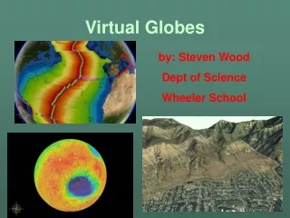
Virtual Globes by: Steven Wood Dept of Science Wheeler School
Virtual Globes • A virtual globe is a 3D software model or representation of the Earth or another world.
Projected on a Globe Image Draped over digital Topography
What A Virtual Globe Can Do For You! • You can look at the globe from different perspectives.
What A Virtual Globe Can Do For You! You can drape the globe with different images and data, and change what is displayed at the push of a button
Why Are Virtual Globes Useful In the Classroom • Its is a VISUAL learning tool. Allowing students to visualize concepts that we often teach them verbally. • It is an INTERACTIVE program which the student can freely access and easily manipulate, allowing them to formulate there own questions on a concept and search out the answers to them • It creates an ENGAGING learning environment, bringing elements commonly used to attract students to video games into use in attracting them to explore and learn
Examples Of Virtual Globes • NASA World Wind- educational focus, open source, Measuring tools, lots of layers. • Google Earth- commercial focus, high resolution-most recent data, widely used, linked with other google tools • Microsoft Virtual-Earth- Wants to compete with Google earth • ARC-GIS Explorer- GIS on a virtual Globe
Two Versions of World Wind • World Wind .net • Original version of World Wind • Runs only on PC • Most flexible version • Has lots of layers • Has many options and add-ons • World Wind Java • Still in development • Works across platforms (Mac or PC) • Can be imbedded in web pages • World-Wind versions customized to your use can be produced.
Important Websites for World Wind • World Wind Home- http://worldwind.arc.nasa.gov/ • Download- http://worldwind.arc.nasa.gov/download.html http://worldwind.arc.nasa.gov/java/index.html • Community- http://www.worldwindcentral.com/wiki/Main_Page • Add-ons - http://www.worldwindcentral.com/wiki/index.php?title=Special%3AAllpages&from=&namespace=100 • My Website – hhtp://www.worldwindclassroom.com
How to Drive in World Wind Scroll button (or click both left and right) zooms view in and out Holding Down the right mouse button and moving mouse tilts the view (Up/down) and rotates view (left/right) Holding down left mouse button and moving mouse moves screen Forward/Back and Left and Right
To select or change layers Select icon representing layer on toolbar Turn on or off place names or boundaries here Or select from the list of layers in the layer manager
What makes World Wind Unique • Open Source- The code for the program is publicaly available and can be altered. • Many useful add-ons have been created for the program by users • You do not need to worry about copywrite issues • You can alter the program yourself (xml) • Educational Focus- Program was created with education in mind. • Lots of different layers • Lots of connection to NASA educational resources • Easy to use interface (designed like a computer game)
Using World-Wind In The Classroom • As a visualization tool in the class lecture, presentation or discussion - Show students imagery or data from World Wind to illustrate concepts or pose questions. • Used to create images for power points or assignments • Students can work with program itself to explore concepts or answer question in a computer lab or for homework.
Uses For World Wind Find your house and understand your local geography (Urban Area image of The Athenian School California)
Boundaries and Place Names Blue Marble (with boundaries and labels)- South Africa
Rapid Fire Modis Daily Satellite imagery capturing ecological and geological events Modis image of Hurricane Katrina
Web Mapping ServerAllows global environmental datasets to be displayed
Shows path explorers took with stop points that link to web pages describing the journey Lewis and Clark Trail
Katrina Add-On Add-on has aerial photography of New Orleans and Mississippi before and after Hurricane