HURRICANE EARL SUMMARY
100 likes | 139 Vues
Get updated information on Hurricane Earl, a Category 4 storm. Learn about projected impacts on Southern New England. Expect high seas, strong winds, heavy rain, and potential storm surge flooding.

HURRICANE EARL SUMMARY
E N D
Presentation Transcript
HURRICANE EARL SUMMARY UPDATED AUGUST 31, 2010 2:30 PM
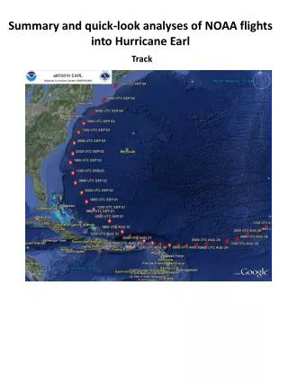
HURRICANE EARL PROJECTION • Major category 4 hurricane currently but may encounter dry air to the northwest • NHC track has Earl passing 50 to 100 miles southeast of Nantucket as category 2 or 3 hurricane • Consistent with most computer models that show passage near or just east of 40N 70W “Benchmark” • Average track error 150 miles either side this far out • Interaction with northern U.S. weather system may be critical player
SOUTHERN NEW ENGLAND IMPACTSMarine • High seas, high surf, and dangerous rip currents likely Thursday through Saturday • Swells from Earl likely by early Thursday • Dangerous rip currents likely along most ocean exposed beaches whether south or east facing Thursday through Saturday • Seas over open coastal waters • 10 to 20 feet to left of track • 20 to 30+ feet very near track • 30 to 40+ feet to right of the track
HURRICANE EARL IMPACTSWind • Slightly greater than 50/50 probability to Tropical Storm Force winds Cape Cod, Martha’s Vineyard and Nantucket • Around 50/50 risk of hurricane force gusts outer Cape and Nantucket • 20 to 30 percent chance of tropical storm force gusts rest of southeast MA along and SE of I-95 corridor (including Boston) as well as southern Rhode Island
HURRICANE EARL IMPACTSHeavy Rain/Flooding • Increasing likelihood of 1+ inches of rain across much of southern New England Thursday night through Friday evening • Axis of 4 to 7 inches of rain possible Cape and Islands • Modest shift of track to west could place axis of 4 to 7 inches of rain across Rhode Island and rest of eastern Massachusetts • Greatest flood risk will be urban drainages
HURRICANE EARL IMPACTSStorm Surge Flooding • Storm surge of a few feet due to northeast winds could cause flooding along Nantucket Harbor and northeast shore of Martha’s Vineyard, if coinciding with Friday evening high tide • If Hurricane Earl passes closer to outer Cape, then some concern for storm surge flooding behind the storm for Wellfleet and Provincetown harbors