AMESD global picture
310 likes | 613 Vues
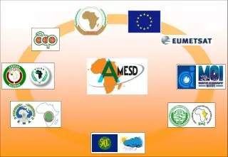
AMESD global picture. African Union Commission. A continental wide project Pan-african. European Union Commission - 9th EDF - 21 M€ - 2008 / 2012. 5 Regional Economic Communities. AMESD project in the SWIO 5 th National Ocean Science Forum Reduit, Mauritius

AMESD global picture
E N D
Presentation Transcript
AMESD global picture African Union Commission A continental wide project Pan-african European Union Commission - 9th EDF - 21 M€ - 2008 / 2012 5 Regional Economic Communities
AMESD project in the SWIO5th National Ocean Science Forum Reduit, Mauritius 8th June 2009
Presentation • African MonitoringofEnvironmentfor a SustainableDevelopement • AMESD project • EUMETSAT • AMESD-IOC THEMA and activities Outline
AMESD Overall Objectives • to facilitate access to environmental information derived from earth observation technologies • to increase the information management capacity of African regional and national institutions
AMESD objectives • To improve access by African users to existing basic Earth Observation data • To establish operational information services in the fields of environmental management • To strengthen political and policy development frameworks for ensuring an active participation of African governments in the global environmental surveillance Initiatives. • To ensure an adequate technical level of AMESD African stakeholders
AMESD the follow-up to PUMA PUMA Deployment of 55 MSG receiving stationsin 46 African Countries Partners : EUMETSAT &National Météo services Beneficiaries :National Météo Services all stations installed in National Météo services since Nov. 2005
AMESD project structure ProgrammeCoordinationUnit Programme Coordinator AUC (Adis-Ababa) Technical Assistance Regional Partners and networks Regional Partners and networks Regional Partners and networks Regional Partners and networks Regional Partners and networks DRAO - African Union Commission European Commission EC Delegation (Addis Ababa) Programme Steering Committee EC, EUMETSAT, WMO Regional Economic Communities – RECs A C P DG AidCo JRC CEMAC ECOWAS IGAD IOC SADC EUMETSAT EUMETSAT RIC (CEMAC) RIC (ECOWAS) RIC (IGAD) RIC (IOC) RIC (SADC) Regional Implementation Center (RIC) Mauritius Oceanography Institute
AMESD Technical Assistance (TA) • 9 permanent staff • 3 in Addis-Ababa (PCU) • 1 in each Regional Implementation Center • 1 “home support” (Thales Alenia Space) • 60 men/month of international short-term expertise
5 Themes for the 5 Regional Economic Communities THEME : « Mitigation of land degradation & natural habitatconservation » RIC :ICPAC, Nairobi THEME :«Crop and rangeland management» RIC :Cilss, Agrhymet Niamey THEME :« Integrated Water Resource Management » RIC :Cicos, Kinshasa, RDC THEME :«Agricultural & Environemental ressource management» RIC :NMS Gaborone, Botswana THEMEMarine & Coastal management RIC:Mauritius Oceanograpy Institute, Maurice
AMESD - EDF Financing agreement ( 21 M€ ) • Long & short term Technical Assistance 9,3 M€ • Maintenance of PUMA Stations and new receiving station1,2 M€ • Develt. and delivery of environemental monitoring services8,0 M€(Grant Agreements managed by the RICs) • Continental harmonization (AMESD fora, networking,…)1,7 M€ • Programme Monitoring, Evaluation, Audit, contingencies 0,8 M€
20 Member States & 10 Cooperating States Croatia Austria Belgium Finland France Denmark Italy Germany Greece Ireland Luxembourg The Netherlands Portugal Norway Slovak Republic Sweden Switzerland Spain Turkey United Kingdom One main Partner : EUMETSAT Member States Cooperating States Czech Republic Estonia Bulgaria Hungary Latvia Iceland Poland Romania Lithuania Slovenia
EUMETSAT’s mission 60 N Meteosat-9 (0° Longitude) Meteosat-8 (3.4° W) Meteosat-7 (57.5° E) Meteosat-6 (67.5° E) 0 60 S 80 20 160 140 120 100 80 60 40 20 0 40 60 100 120 140 160 180 “... to deliver operational satellite data and products that satisfy the meteorological and climate data requirements of its Member States - 24 hours a day, 365 days a year, through decades.“
EUMETSAT - Monitoring the Oceans Jason-2 Precise and continuous altimetry data through laser technology Launched in June 2008
EUMETCast Services HB-6, Ku-Band Coverage AB-3, C-Band Coverage NSS 806, C-Band Coverage EUMETCast Africa • EUMETSAT Satellite Data (MSG / Metop) • EUMETCast products (atmosphére, marine, land) • Third Party Satellite Data – GOES (USA) / MT-SAT (Japan) / FY2 (China) • In-situ / observational data – DCP • Numerical Weather Forecasts MoU signed between EUMETSAT and AUC Free acess to EUMETCAST satellite data and products for AMESD partners
THEMA « Coastal and Marine management » Regional Economic Community : Indian Ocean Commission Regional Implementation Center: Mauritius Oceanography Institute, Quatre Bornes IOC countries Maurice / Madagascar Seychelles / Comores /La Réunion African east cast countries Kenya / Mozambique / Tanzania Partners: I.O.C. countries and East African coast countries
Fishing overview • “Fish” global production : 100 millions tons / year (7% Europe fleet, less 1% SWIO countries local fleet) • “Meat” global production : 200 millions tons • About 25 % of global protein supply • 300 millions people live on fishery activity • Toward 2020, “fish” production must increase to 20 millions tons (FAO Source) • Over-exploitation and stocks apparent collapse (economy and ecosystem impact)
IOC THEMA – Coastal and marine managementPractical Earth Observation date uses for fisheries management Ocean Color Sea Surface Temperature Altimetry Wind : speed, direction
THEMA « Coastal and Marine management » Objectives • develop operational products and services using ocean observation data Three kind of services will be developed : 1- to support for the management of fishery resources in the SWIO 2- to help to monitor and control fishing activities in the SWIO 3- Physical oceanography and support for the management of maritime risks • improve the regional access to satellite Earth and Ocean Observation data • installation of satellite receiving stations (EUMETCast) • dissemination of products and services • strengthen the capacities of MOI and regional technical partners in the processing and analysis of ocean observation data
THEMA « Coastal and Marine management » Partners and beneficiaries Regional Partners • Madagascar : Minis. Fisheries (CSP), IHSM • Comores : Minis. Fisheries (CSP) • Seychelles : Seychelles Fishing Authority, IOTC,.. • Mauritius : M.O.I., Minis. Fisheries (CSP) • Mozambic : IIP, other to be identified • Kenya : KMFRI, other to be identified • Tanzania : to be identified • contribute to developments • equipped to receive EUMETSAT data • trained to ensure the continuity of an operational service End-users • fishing and marine authorities • artisanal fisheries operators • Oceano and research institutes • environmental agencies
THEMA « Coastal and Marine management » • Equipment • Eumetcast receiving stations • Océano. Instruments for data calibration • Training sessions • Spatial oceanography • Data processing : ocean color, altimetry… • Link ocean parameters / fish resources • Using Eumetcast receiving stations and AMESD products and services • … • Research and development • New products and software • Services: archives,… • Validation and diffusion of products and services • ground truthing measurements • data dissemination
IOC THEMA – Coastal and marine management THEMA products and services
MERCATOR Model results Jason OSDR Sea Surface Winds Meteo Models JASON Sea Wave Height Sea Surface Temperature MODIS Chlorophyll MERIS FR ADT data Input Products De-clouding De-clouding Oceano analysis. Absolute Dynamic Topography Meteo analysis. Chlorophyll processing Maps of currents, salinity, Temp. layers Map of sea levels and gyre Maps of marine winds and wave measurement and forecast Map of averaged temp. / thermal fronts Map of chlorophyll levels Intermediate products Computation of statistics and trends Archive of potential fishing zone maps Statistics on CHL-a, SST Statistics on meteo and environment parameters Visualisation tools Final products ocean. Parameters Archive Archive of VMS Fish capture evolution Climatical evolution Fishing stat. Fisheries data base Impact assessment on maritime resources Decision support products Climatic evolution Maritime resources trend Ministries of fisheries, halieutic research centers IOC THEMA – Coastal and marine management THEMA products and services1 - Support for the management of fishery resources
IOC THEMA – Coastal and marine management THEMA products and services
MERCATOR Model results ADT data Jason OSDR Sea Surface Winds Meteo Models JASON Sea Wave Height Sea Surface Temperature MODIS Chlorophyll MERIS FR Input Products De-clouding De-clouding Meteo analysis Absolute Dynamic Topography Reception Processing performed by the RIC Chlorophyll processing Oceano analysis Maps of currents, salinity, Temp. layers Map of sea levels and gyre Maps of marine winds and wave forecast Map of averagedtemp. / thermal fronts Map of chlorophyll Levels Visualization tools Temp., thermal front, Chlorophyll levels, sea level and gyre Potential Fishing Zone Sea winds, waves… Ships positions VMS ships position Computation of fishing areas Potential Fishing Zone Final products Sea security report Processing performed by the Fishing Control Centres Fishing areas reports generation Decision support products Marine meteo observations & forecast Maps of potential fishing zones artisanal fishing communities (localization of potential fishing zone, marine meteorology forecasting...), marine authorities (Coast Guard, Search and rescue services, Port authorities...). IOC THEMA – Coastal and marine management THEMA products and services2 - Monitoring and control of fishing activities Intermediate products
IOC THEMA – Coastal and marine management THEMA products and services
IOC THEMA – Coastal and marine management THEMA organization and partnerships • MOI team • 5 MOI permanent staff each in charge of one component • additional staff under contract • short term expertise (10 month) • Regional partnerships (MoU) contribute to: • the development of products, regarding the analysis of correlations between fishing data (in their respective countries) and oceanic parameters • in-situ measurements and collection of data for the validation of products • dissemination of products and services benefit of : • training • equipments (receiving stations, …)