Download
1 / 10
100 likes | 301 Vues
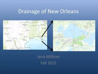
Drainage of New Orleans. Jena Milliner Fall 2012. Objectives. Compare FEMA Flood maps to major recent flooding event. Analyze pumping stations of the city. Find areas at high risk for unpredicted flooding. Pumping Stations. Drains all water the city 23 main pumping stations

E N D
Drainage of New Orleans Jena Milliner Fall 2012
Objectives Compare FEMA Flood maps to major recent flooding event Analyze pumping stations of the city Find areas at high risk for unpredicted flooding
Pumping Stations • Drains all water the city • 23 main pumping stations • Some largest in the world • Divided into 5 regions of the city
Drainage capacity • Pumping density = • (∑ pumping capacity for region)/ area of region • East and Lower Algiers regions had the lowest pumping density • BUT East has 8 pumping station while Algiers, Lower Algiers, and Lower 9th have only 1 • Metro and Algiers have highest population density, Lower Algiers has lowest.
Recent flooding events • Flood of May 1995: rained 20 inches! in 48 hours • Hurricane Katrina: Storm surge caused breaches in levee system • Flooded areas of New Orleans from 1995 Flood not available • Used areas from Katrina instead
Katrina Flooding • Water stopped rising when level with Lake Pontchartrain • Water level on September 1, 2005 was 2.5ft • Little /No flooding west bank of Mississippi River
Comparison to FIRM • Pink areas A: Flood in 100 year event • Orange areas X: Do NOT flood in 100 year event • Purple areas had unpredicted flooding • Yellow areas did not flood when expected • Some error with yellow area
Summary • East and Lower Algiers have lowest pumping density • Lower Algiers, Algiers, and Lower 9th have only 1 pumping station • Lower 9th and East had most unexpected flood • East, Lower 9th, and Lower Algiers have greatest risk of unexpected flooding
Addition analysis • Compare to May 1995 Flooding • Analysis a pumping station level • Infiltration rates – soil and land use • Runoff calculation • Critical Rainfall event
Questions? References Data/information sources: • FEMA FIRM shapefiles @ http://atlas.lsu.edu/ • Tiger shapefiles @ http://www.census.gov/geo/www/tiger/tgrshp2011/tgrshp2011.html • American Fact Finder @ http://factfinder2.census.gov/faces/nav/jsf/pages/index.xhtml • http://danswenson.com/paper/katrina.html • http://www.nolaenvironmental.gov/nola_public_data/projects/usace_levee/docs/original/OrleansEAErrata.pdf • http://blog.nola.com/stormwatch/2007/05/no_pump_stations_ready_to_face.html • Turnipseed, D. P., W. T. Baldwin, L. M. Cooper, and P.C. Floyd, 1995: "Flooding in Coastal Areas of Mississippi and Southeastern Louisiana, May 9-10, 1995", U.S. Department of the Interior, U.S. Geological Survey, Fact Sheet FS-155-95. • ArcGIS basemap • Davis, W. D., 2000: “Historical Perspective on Crevasses, Levees, and the Mississippi River”, Transforming New Orleans and Its Environs, University of Pittsbrugh Press, 89. Images: • http://www.bkiusa.com/services-projects/engineering/drainage-pump-stations/i-10-railroad-underpass-pump-station.aspx • Google maps streetview • ArcGIS basemap • Turnipseed, D. P., W. T. Baldwin, L. M. Cooper, and P.C. Floyd, 1995: "Flooding in Coastal Areas of Mississippi and Southeastern Louisiana, May 9-10, 1995", U.S. Department of the Interior, U.S. Geological Survey, Fact Sheet FS-155-95.


![[PDF]❤️DOWNLOAD⚡️ Cityscapes of New Orleans](https://cdn7.slideserve.com/13192220/cityscapes-of-new-orleans-dt.jpg)