Download
1 / 11
110 likes | 258 Vues
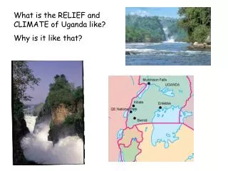
What is the RELIEF and CLIMATE of Uganda like? Why is it like that?.

E N D
What is the RELIEF and CLIMATE of Uganda like? Why is it like that?
As early as 150 AD Ptolemy had written of the "Mountains of the Moon", where snows fed the lakes, sources of the Nile". The Rwenzori range lies along the western border of Uganda; it includesAfrica's third highest summit, Point Margherita (5109m).
Entebbe airport Warm all year Over 20*C Wet all year Very wet in April and May Most sunshine in January Very humid Climate:
The red line shows the temperature measured in degrees Celsius. Kampala is almost on the equator so the temperature is always high. Kampala is 1144m above sea level – it is high up and so this makes it less hot than most equatorial places.
The rainfall columns are measured in mms or cms. April and November are the highest columns here. They have about 150mms of rainfall. It is wet all the year round but is slightly drier around January and June. The total is about 1100mms a year.
Climate:The majority of the country has a tropical climate which varies according to altitude. During the year the hottest months are from December to February when the temperature reaches 29 degrees Celsius. The rainy seasons are from April to May and October to November, with the wettest month being April. Rainstorm over Lake Victoria
Temperatures in some parts of the country can be quite cool owing to the country’s high altitude, despiteits position on the equator. The mountain areas become much cooler and the top of Mount Elgon is often covered with snow. Other parts of the country are much warmer. View from the top of Mt. Elgon
Uganda – Relief (Height) A bit lower Very high Mount Elgon It is nearly all Highland = brown
Uganda - Relief Lake Victoria in the south provides an extensive, lush, and fertile shoreline. Set over 1,100 metres above sea level it is also the source of the river Nile, which meanders northwards through Uganda providing valuable irrigation for farmland. In the east of the country, on the border with Kenya, the craggy snow-capped extinct volcano of Mount Elgon rises majestically from open moorland and dense jungle. It is in this mountain area that most of Uganda’s coffee is produced. The north of the country is a plateau covered by extensive savannah grassland, and mountains again rise in the west forming the border with Congo. It is here that the majority of Uganda’s national parks are also located. Mount Rwenzori, in the famous Mountains of the Moon, named for their mist-shrouded snow-capped peaks, hosts some of the finest montane (mountain) forest in all of Africa. Here in the west there is wildlife like the gorillas
Plateausavannah grassland Mount Elgon Coffeegrown Mount Rwenzori (mountain) forest Lake Victoriasource of River Nile