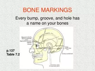
Stadia markings + rod
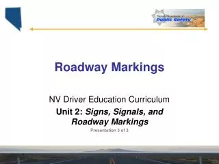
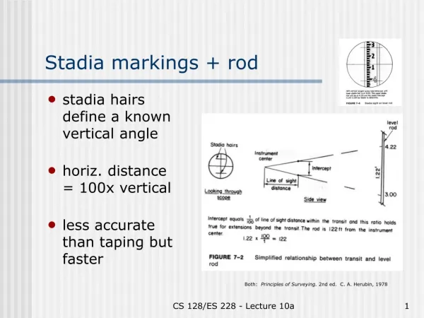
Stadia markings + rod. stadia hairs define a known vertical angle horiz. distance = 100x vertical less accurate than taping but faster. Both: Principles of Surveying. 2nd ed. C. A. Herubin, 1978. Electronic Distance Measurement. Optical: uses parallax. Inexpensive but error ≥ 1%

Stadia markings + rod
E N D
Presentation Transcript
Stadia markings + rod • stadia hairs define a known vertical angle • horiz. distance = 100x vertical • less accurate than taping but faster Both: Principles of Surveying. 2nd ed. C. A. Herubin, 1978 CS 128/ES 228 - Lecture 10a
Electronic Distance Measurement • Optical: uses parallax. Inexpensive but error ≥ 1% • Ultrasonic: mid-priced.Accuracy ~ 0.1% • Laser: moderate to very expensive. Accuracy 1 ppt or better CS 128/ES 228 - Lecture 10a
Measuring elevations • Known as “leveling” • Uses a level (optical or laser) & a rod • All measurements are relative (to a starting elevation) • Height of instrument Both: Elements of Surveying. U. S. Army, TM 5-232, 1971 CS 128/ES 228 - Lecture 10a
Optical vs. laser leveling • Optical leveling requires 2 workers • Laser leveling can be done alone, but easiest when rod is equipped with autodetector (high/low/on signals) Top: Principles of Surveying. 2nd ed. C. A. Herubin, 1978Bottom: Topcon web site CS 128/ES 228 - Lecture 10a
Putting it together Two ways of mapping a region: • Traversing – used to locate specific features • Triangulation – used to establish a control network over a region Both: Elements of Surveying. U. S. Army, TM 5-232, 1971 CS 128/ES 228 - Lecture 10a
Types of traverses Allowable “misclosure” • First order, Class I:- 4 mm in 1 km- 127 mm in 1000 km • Third order:- 12 mm in 1 km- 380 mm in 1000 km • Land surveys: ??? Both: Elements of Surveying. U. S. Army, TM 5-232, 1971 CS 128/ES 228 - Lecture 10a
The total station • Combines theodolite, EDM, data logger & surveying software • Log ~ 8000 points, download data to computer • Why doesn’t ES have one??? CS 128/ES 228 - Lecture 10a Topcon web site