Journey Through Earth's Formation and Structure
280 likes | 316 Vues
Discover how Earth formed 4.6 billion years ago through accretion and explore its inner layers like the crust, mantle, and core. Learn about minerals, rocks, and the fascinating theory of plate tectonics. Dive into the Earth's geological cycle and the evidence supporting continental drift.

Journey Through Earth's Formation and Structure
E N D
Presentation Transcript
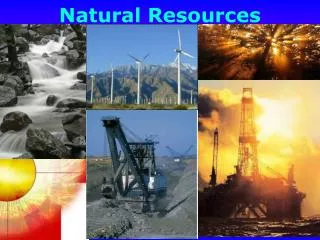
Earth Systems & Resources APES: Chapter 8
Formation of Earth & Solar System Approx. 5 billion years ago gas & dust from an exploded star converged under the force of gravity into a spinning disc called a planetary nebula. Earth formed in a process called accretion where materials clumped together to form larger masses (increasing gravity of that mass).
Earth is 4.6 billion years old and is a rocky inner planet. High melting point materials coalesced near the sun (i.e. rock & metal). Low melting point materials (gas & ice) coalesced far from the sun. Earth’s surface was molten due to heat from asteroid bombardment and nuclear fission of radioactive elements.
Most dense materials sank to the center of the molten Earth: Fe, Ni, U, Pu (metals). These layers are the inner & outer core. Least dense materials make up the top layers: O, Si, Al, Ca, Mg (rock). These layers are the mantle & the crust. Inner core is solid due to intense pressure & heat. Heat in Earth’s interior is from the decay of radioactive elements.
Earth’s Structure • Crust: • Two types – oceanic & continental • Mantle: • Two layers – upper (asthenosphere) & lower • Outer Core: • Liquid Fe & Ni • Inner Core: • Solid Fe & Ni • Very Hot!!
Earth’s Structure • Lithosphere “plates” • Crust + Solid upper mantle • Rigid, broken into plates • Asthenosphere • Magma originates • Slowly deforming solid (ductile) • Convection • Fe, Mg Silicates (SiO2) • Lower Mantle • Solid • Fe, Mg Silicates (SiO2)
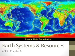
Earth’s Structure How do we know? • Indirect Evidence • Seismic Wave Studies • Density measurements • Heat Flow Measurements • Lava Analyses • Meteorite Composition
Minerals vs Rocks • Minerals: • Composed of elements • Form crystals • Most common is SiO2 (aka quartz) & Feldspar • Unevenly distributed around the Earth • Can be a native element like gold or a compound like quartz. • Rocks: • Composed of minerals • Three types – igneous, sedimentary & metamorphic • Molten form inside the Earth is magma; surface of the Earth is called lava • Igneous rocks are the most common. • Make up the crust
Minerals Rocks Granite Rock
Types of Crust • Continental Crust • Less dense • Made of Granite Rock • High in silica • Less Iron • Thick • Floats • Ocean Crust • More dense • Made of Basalt rock • High in Iron • Less Silica • Thin • Sinks Major Elements in the Crust: Oxygen, Silicon, Aluminum, Iron, Calcium, Sodium, Magnesium, Potassium Major Minerals/Elements Mined: Copper, tungsten, iron ore, diamonds (precious stones), gypsum, gold (precious metals), aggregate (sand, gravel)
Convection & Hot Spots • Radioactive decay in the core releases heat . . . Heat causes plumes of hot magma in the mantle to well upward . . . . Plumes produce hot spots. A hot spot is where molten material reaches the lithosphere (crust).
Convection & Hot Spots Hot spots are found all over the Earth. There are two hot spots in the US. One in Hawaii and the other in Yellowstone National Park. Hot spots are stationary (they don’t move) and produce volcanic activity on the Earth’s surface.
Theory of Plate Tectonics • Earth’s geological cycle consists of three major processes: • Tectonic Cycle – opening and closing of ocean basins over time. Lithospheric plates are in constant motion. • Rock Cycle – Recycling of the Earth’s crust through erosion, uplift, and volcanism. • Soil Formation – result of the physical and chemical weathering of rock and the accumulation of detritus from the biosphere.
Theory of Plate Tectonics • Timeline: • 1912 – Alfred Wegener proposed “Theory of Continental Drift” based on continental evidence. Defined Pangaea. • 1940’s – WWII and the development on sonar/radar revealed the shape of ocean floor (Harry Hess). • 1960’s – Glomar Challenger (drill ship) collected oceanic crust samples & dated them (radiometric dating techniques). • 1963 – J. Tuzo Wilson proposed “Theory of Sea Floor Spreading” based on ocean floor evidence. • 1965 – J. Tuzo Wilson & Harry Hess proposed “Theory of Plate Tectonics”. Combined both Continental Drift & Seafloor Spreading theories and their collective evidence.
Continental Evidence • Alfred Wegener observed several lines of evidence that supported that the continents were once joined as a supercontinent called Pangaea. • Puzzle fit of the continents (matching coastlines) • Similar mountain ranges across an intervening ocean • Climatic evidence – • Glacier evidence in Africa & S. America near equator • Coal deposits in Antarctica • Fossil evidence – • Identical species of freshwater fossils found in Africa & S. America • Both plant and animal fossils discovered in all southern continents (Gondwanaland).
Ocean-Base Evidence Technology in the late 20th century allowed the collection of ocean-based evidence: • Sonar used in WWII discovered mid-ocean ridge and deep-sea trenches. • Deep-sea drill ships (ODP) collected ocean floor rocks – • Sea floor rocks were volcanic • Sea floor rocks were young in age (oldest 220 Ma) • Sea floor rocks magnetism showed a pattern that was identical to sea floor rock ages • Earthquake data from seismometers showed patterns of earthquakes that were associated with mid-ocean ridges & deep-sea trenches. • Volcanoes also were associated with mid-ocean ridges & trenches.
Theory of Plate Tectonics • States that the Earth’s lithosphere is divided into plates, most of which are in constant motion. Tectonic plates “float” on the convecting asthenosphere. • There are three types of plate boundaries (areas where two or more plates meet): • Divergent Plate Boundary – plates moving away from each other. Seafloor is being created @ this boundary • Convergent Plate Boundary – plates moving towards each other. Seafloor is being destroyed @ this boundary. • Three types depends on crust involved • Transform Plate Boundary – plates are moving past each other (sliding). Ocean crust is neither created nor destroyed.
Divergent Plate Boundary • Create mid ocean ridges • Mid Atlantic Ridge • Ocean crust is created @ MOR • Long chains of submerged volcanic mountains • Igneous Rocks formed • Basalt (pillow basalts) • Minerals at hydrothermal vents • Nicklel, chromium, asbestos, copper, iron Sea floor spreading – Red Sea Deep sea vents/black smokers
Convergent Boundary – Subduction • Volcanic Mountain chains (continents or islands) • Andes • Philippines • Igneous Rocks formed • Andesite • Minerals • Cu, Pb, Ag, Au • Hazards • Volcanoes, Earthquakes, Tsunamis Sea floor is destroyed at subduction zones.
Convergent Plate Boundary – Subduction Zones • Ocean to Ocean Subduction: • Deep sea trenches mark subduction on the surface • Two ocean crust colliding – • Older, colder therefore more dense crust subducts (destroyed) • Volcanic Island Arcs are formed • Parallel the trench • Volcanoes at subduction zones are explosive • Earthquakes & Tsunami’s common • Most destructive EQ ever recorded on subduction zones • Ocean to Continent Subduction: • Deep sea trenches parallel continent • Continental volcanic mountain chains form • All other characteristics the same as Ocean to Ocean
Convergence of India – Collision Zone • High (non volcanic) mountain ranges • Himalayas • Metamorphic Rocks • Minerals • Same associated with sunduction and spreading centers • Hazards • Earthquakes
Transform Boundaries • 2 Plates moving passed one another • San Andreas Fault • Hazards • earthquakes