Download
1 / 25
250 likes | 397 Vues
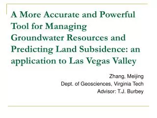
A More Accurate and Powerful Tool for Managing Groundwater Resources and Predicting Land Subsidence: an application to Las Vegas Valley. Zhang, Meijing Dept. of Geosciences, Virginia Tech Advisor: T.J. Burbey. Relationship between land subsidence and hydraulic head. Surface Water.

E N D
A More Accurate and Powerful Tool for Managing Groundwater Resources and Predicting Land Subsidence: an application to Las Vegas Valley Zhang, Meijing Dept. of Geosciences, Virginia Tech Advisor: T.J. Burbey
Relationship between land subsidence and hydraulic head Surface Water Aquifer System Groundwater Figure from Http://www.environment.scotland.gov.uk/our_environment/water/groundwater.aspx
Total stress σ Effective stress σ’ Water pressure Relationship between land subsidence and hydraulic head
Relationship between land subsidence and hydraulic head Pumping well
According toTerzaghi's one-dimensional consolidation theory, deformation occurs only in vertical direction Total stress σ Effective stress σ’ Water pressure Δb is the land subsidence. Sk is the skeletal storage coefficient , and Δh is the change in hydraulic head
Bedrock Sand and gravel Silt and clay interbed A A’ A’ A Sand and gravel Silt and clay interbed Bedrock Fault Geologic cross-section (A-A’) illustrates the stratigraphic and fault relations interpreted from well log data. (From Bell, 2008) Generalized surficial geologic map of Las Vegas Valley
Pumping and Recharging wells Pumping well Recharge well Bedrock Fault Groundwater has been pumped since 1905; More Than 1.5 m of subsidence has been observed since 1935 To help mitigate the ongoing occurrence of land subsidence, an artificial recharge program was initiated in 1989
A significant percentage of the subsidence is delayed relative to the water-level decline 0 210 Water Depth Subsidence 235 20 260 40 285 60 310 1996 2002 1998 2000 2004 2006 Seasonal and long-term subsidence and water level patterns at the Lorenzi site, Las Vegas, Nevada
A significant percentage of the subsidence is delayed from the water-level decline What causes subsidence and delayed drainage?
Subsidence bowls are offset from the major pumping center. Over time, the valley has yielded a very complex subsidence pattern, much more so than the water-level distribution Subsidence map for Las Vegas Valley from 1992 to 1997 (From Bell, 2002)
To better manage groundwater resources and predict future subsidence we have updated and developed a more accurate groundwater management model for Las Vegas Valley Layer1 Near-surface Aquifer Layer2 Developed-zone Aquifer Layer3 Deep-zone Aquifer Layer4 The vertical conceptual model layer distribution (From Yan, 2007)
The model incorporates MODFLOW with the SUB (subsidence) and HFB (horizontal flow barrier) packages 50m-Cell Faults 1.7 million cells Extended simulation period from 1912-2010
Groundwater flow equation The unequilibrated heads within the interbeds can be described by the one-dimensional diffusion equation K is the component of the hydraulic conductivityW is the volumetric flux per unit volume of sources or sinks of waterSsis the specific storageS’sis the specific storage of the interbedKv’ is the vertical hydraulic conductivity of the interbed
Sources of observation data Pumping and Recharging wells Groundwater monitoring network Groundwater level data can be obtained from the USGS Las Vegas Valley Water District and State Engineer’s Office will provide needed pumping and artificial recharge data for the extended period of record
Land subsidence data Benchmarks established in 1935 and 1963 GPS InSAR and PS-InSAR Currently only one continuous GPS station has been monitored for more than a few years Provides surface deformations from interferometric synthetic aperture radar (data available from 1992-2010) Subsidence map for the period 1963-1980 (from Bell, 2008) (left)
Permanent scatterer velocity maps (2002-2010) showing target velocities in mm/yr for the Las Vegas basin BLUE= Uplift RED= Subsidence mm/year (provided by Youquan, Zhang)
Limitation of the traditional inverse method How to specify the number ofzones ??? ?? ? Where each zone is for each parameter ???
The objective of this investigation Observed drawdown Observed land subsidence MODFLOW APE (Adjoint Parameter Estimation) algorithm and UCODE Automatically identify suitable parameter zonations Inversely Calibrate Hydrologic Parameters
Objective function Minimize |hsimulated-hobserved| + |subsimulated-subobserved| • h is the groundwater level • sub is land subsidence
To verify the validity of the algorithm, a MODFLOW 2000 hypothetical model is developed, and the APE algorithm is executed to create approximate spatial zonations of T, Sske and Sskv Estimated Transmissivity Zones after 3 Iterations True Synthetic Transmissivity Zones Note that the colors in each frame only indicate different zones and the colors (number of zones) change after each iteration
Estimated Specific Storage Zones after 3 Iterations True Synthetic Specific Storage Zones The estimated zonations approach the true parameter zonations
Observed vs. simulated (a) final drawdown, and (b) final subsidence.
Where do we go from here? Our next goal is to apply the APE algorithm to Las Vegas Valley to build a complete management model for water purveyors If necessary, global methods will be employed A parallel method will be incorporated
Conclusions An updated groundwater management model for Las Vegas Valley model is being developed. We have outlined an automated parameter estimation process that can greatly aid the calibration of ground water flow models like those of LVV. Accurate parameterization will provide a far more accurate and precise groundwater model that can be used to more accurately predict future trends on the basis of future pumping patterns.