Download
1 / 30
300 likes | 426 Vues
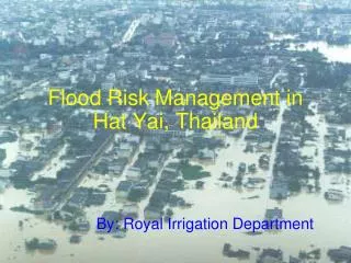
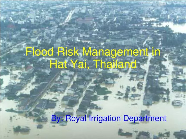
Flood Risk Management in Hat Yai, Thailand. By: Royal Irrigation Department. The most rapid economic growth city, and the most populated urban area in Southern Thailand. One of Largest commercial and tourist city in the Southeast Asia region. The center of trades of the Southeast Asia.

E N D
Flood Risk Management in Hat Yai, Thailand By: Royal Irrigation Department
The most rapid economic growth city, and the most populated urban area in Southern Thailand
One of Largest commercial and tourist city in the Southeast Asia region
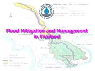
Location of Utaphao river basin and characteristic of the river basin.
High Frequency of Flood Risk Hat Yai had been under a series threats of floods for many years: • 1833 1916 1942 1959 1961 1962 1966 1967 1969 1972 1973 1974 1976 1981 1983 1984 1988 2000 2003 2008 2009 • Floods occur almost every year !!! • Big floods 1973 1983 1,000 Million THB 2000 massive losses
http://thailandwanderer.blogspot.com/2009/12/hatyai-great-flood-in-year-25432000.htmlhttp://thailandwanderer.blogspot.com/2009/12/hatyai-great-flood-in-year-25432000.html
http://thailandwanderer.blogspot.com/2009/12/hatyai-great-flood-in-year-25432000.htmlhttp://thailandwanderer.blogspot.com/2009/12/hatyai-great-flood-in-year-25432000.html
Flood Mitigation of Utaphao river basin and Hat Yai city 1. Structural measures • Improvement of natural water drainage system, natural canal extension to improve drainage efficiency of canal for a distance of 46.90 km. • Flash flood drainage management, main drainage system work including a water gate to transfer water from Utaphao canal to Songkhla lake (length 21.343 km). • A water diversion canal (length 26 km) and water gate will drain water from Utapho canal outside Hat Yai town and relief flood in lower Utaphao canal.
Flood Mitigation of Utaphao river basin and Hat Yai city • A diversion canal was built to discharge excess flow directly to the sea. • Construction of embankments, improvement of drainage canals • Reservoir area improvement • Reservoir area water way construction • Provision of drainage pumps.
Songkla lake Rama 3 Flood canal Rama 4 Flood canal Rama 1 Flood canal Khlong Utaphao Rama 5 Flood canal Natural canal Flood diversion canal Hat Yai city Utapao flood gate Rama 6 Flood canal flood gate
Diversion canal Flood gate in main canal Flood gate in sub-canal Diversion sub-canal
2. Nonstructural measures • Monitoring the climatic and hydrologic situation of the Utaphao River using information from Thai as well as foreign meteorology websites. • Water situation prediction and mitigation consist of climate, rainfall, discharge, water level monitoring in reservoirs, rivers and typhoon. • Water management in the watershed to indicate mitigation and flood warning level. • Public warning for advance flood preparation to relief damage of prosperities and lives. • Water analysis center at Songkhla Irrigation project.
High Potential of Observations and monitoring • Meteorology: TMD • Doppler Radar • Regional Met. Center to be a major department to closely monitor &/ give essential advices/ warnings • Dense observation networks, accessible satellite data, and • 4. Numerical Precipitation prediction Model (NWP/ WRF)
Utaphao river basin Telemetry System • Real-time telemetry in Utaphao river basin consists of one main station and 13 field stations. • It measures rainfall and discharge every 15 minutes. • Data are sent via a VHF radio network to the main station for data analysis and flood prediction. • Flood warning is provided 9 to 16 hours in advance. • The efficiency of the telemetry system will be increased when we add a GPRS system and 5 more field stations.
Telemetry System in Utaphao river basin Hat Yai city river Remote station Master station Malaysia
Flood forecasting and warning system • FloodWork Server was located at the Royal Irrigation Department Southern Regional HQ in Hat Yai. • This server was linked to a telemetry computer which receives all of the latest observed hydrological and hydraulic data from the Utaphao basin. • Automated forecast simulations were set up, so that forecast simulations are carried out at regular intervals, ideally just after the telemetry system has been set up. • Series of client computers, connected via leased line network connections to the main flood forecesting server, were set up to display the results of the flood forecast simulations
Flood forecasting system for the Utaphao River Basin using the Floodworks software (MWH Soft)
Flood forecasting by water level (state correlation) • Flood forecast and warning in Hat Yai town using discharge data collected at different points along the Utaphao Canal can provide flood warning in advance of 20 to 21 hours. The flood routing period is variable, according to discharge in Utaphao canal. We developed statistical relationships between the flood peaks of two hydrological stations upstream of Hat Yai city and used the relationship to predict floods in the city. • The two stations include X.173A (37 km above Hat Yai town) and X.90 (14 km. above Hat Yai town).
Flood forecasting by water level (state correlation) 17.85 m. 7 hr. 9.51 m. 16.90 m. 12 hr. 8.87 m. 15.60 m. 18-19 hr. 8.00 m. Khlong Utaphao 23 km. 12 km. Ban Muangkog Utaphao flood gate Ban Bangsala
State relationship between X.173A station, X.90 station and Khlong Utaphao gate +8.87 m. 441.00 m3/s +16.90 m. 213.00 m3/s Closely monitor Q Rama1 = 220 m3/s 12 hr. 3 hr. Q = 620 m3/s 23 km. Q = 400 m3/s 12 km. X.173A station X.90 station Utaphao flood gate
State relationship between X.173A station, X.90 station and Khlong Utaphao gate +9.51 m. 774.00 m3/s +17.85 m. 346.00 m3/s Flood warning Q Rama1 = 465 m3/s 7 hr. 2 hr. Q = 930 m3/s 23 km. Q = 465 m3/s 12 km. X.173A station X.90 station Utaphao flood gate
17 Pumping station in upper Utaphao river basin Water management by pump setting
Assistance/ support needed in UFRM 1. Expertise in QPE/ QPF development and improvement 2. Technology/ expertise in Flood Modeling improvement and inundation flood map Guidances & technical supports:
Conclusion: ## To reduce losses of lives and economy due to floods in city,…… urban flooding management strategy from meteorological aspect needed to be formulated and implemented properly. ## The disastrous impacts can be managed ………….by suitably implementing flood management measures, with collaborative efforts of all sectors of the whole community. ## Hat Yaiis ready to participate in the Pilot City in the UFRM program of Typhoon Committee
THANK YOU Aerial view of cars and trucks at higher ground along the bridge flyover http://thailandwanderer.blogspot.com/2009/12/hatyai-great-flood-in-year-25432000.html