Download
1 / 17
170 likes | 321 Vues
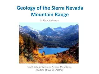
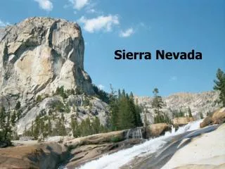
Introduction to the Sierra Nevada and Mono Basin. Prepared by Dr. Michael J Passow Earth2Class Workshops for Teachers 17 Nov 2012. Sierra Nevada (“snow-covered mountain range”) forms part of the Pacific Province.

E N D
Introduction to the Sierra Nevada and Mono Basin Prepared by Dr. Michael J Passow Earth2Class Workshops for Teachers 17 Nov 2012
Sierra Nevada (“snow-covered mountain range”) forms part of the Pacific Province The Pacific Province lies between several tectonic plates, and includes the active volcanoes of the Cascades, as well as the coastal mountains of California This is part of the dynamic geology stretching from Alaska to the tip of South America
Sierra Nevada http://geomaps.wr.usgs.gov/parks/province/pacifmt.html In general terms, the Sierra Nevada can be thought of as a huge tilted fault block. Mono Basin lies on the eastern edge.
Major Characteristics of the Sierra Nevada • Quite different from the nearby Cascades • Approximately 640 km/400 mi north-south, 105 km/65 mi west-east • Located between CA Central Valley and NV Basin and Range http://upload.wikimedia.org/wikipedia/commons/7/7c/Sierra_Nevada_map.png
Rocks of the Sierra Nevada http://virtual.yosemite.cc.ca.us/ghayes/granite.htm Primarily gray granite of Mesozoic age Arc-shaped volcanoes erupted through older rocks, but batholith solidified deep underground Really many interlocking magma bodies
Erosion • By late Cretaceous, most of the volcanoes had eroded and the once-deep granite began to be exposed • Just a few thousand feet high in the early Cenozoic http://www.smashinglists.com/beautiful-waterfalls-world/
Uplift and Tilting • During Miocene (20 mya), continental crust east of the Sierra Nevada began to stretch east-west, creating the Basin and Range province • 5 mya, the Sierra Nevada began to rise along its eastern margin as the area to the east down-dropped • Basically, a tilted fault block with gentle western slope and steep eastern slope
Pleistocene Glaciation • As the Sierra Nevada rose, the Pleistocene Epoch brought alpine glaciers to the region • U-shape valleys formed as glaciers carved out stream valleys • Best examples include sheer walls and hanging valleys of Yosemite
Brief History of Mono Lake • Formed perhaps 760,000 years ago • Native Americans of Paiute descent foraged in the area for thousands of years before first explorers arrived in the 19th century • Name may come from Yokut term applied to tribes on either side of the lake, “Monachi”
Mark Twain’s Roughing It • Sam Clemens visited the area while in the Nevada Silver Rush of 1863, and later wrote about it in his 1872 travel book • Chapters 38 & 39 provide a wonderful combination of description and exaggeration • Excellent source for developing ELA-Science interdisciplinary lessons
City of Los Angeles began to divert water from tributaries in early 1940s • Lake volume halved, salinity doubled, ecosystem collapsed http://www.monolake.org/about/story
Islands became peninsulas • bird nesting places became vulnerable to mammals and reptiles • Photosynthetic algae decline, affecting brine shrimp • Air quality worsens as air-borne particulates increased
Mono Lake Committee 1978 • Local residents began drive to save the lake • 20,000+ members joined to gain legal and legislative support http://www.monolake.org/about/story
From Mt Warren on the west, 2,000 m/6,000 ft drop to Mono Lake • About 20 km/13 mi across surface • Tufa-covered boulders http://www.monolake.org/about/geology
Surrounded by Volcanoes http://www.monolake.org/about/geovolcanic Bodie Hills to the north Cowtrack Mountains to the east Mono Craters to the south Last eruption about 700 years ago
Closed basin with no outlet • Streams and springs supply water • As much as 1,300 m/4,000 ft can evaporate during a year • Salinity can be 2 – 3 times that of the ocean • Volcanic eruptions also add to lake chemistry http://www.monolake.org/about/geolake
Landsat image of Mono Lakehttp://upload.wikimedia.org/wikipedia/commons/6/6c/Wfm_mono_lake_landsat.jpg