Download
1 / 1
10 likes | 178 Vues
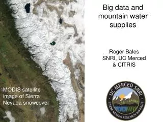
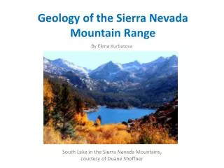
Scales of Sierra Nevada watersheds Fewer than 20 main rivers, each of which drains 1,000-5,000 km 2 above the mountain front The greater San Joaquin (mountains & valley together) is on the order of 35,000 km 2 , or 50,000 km 2 including the Tulare Lake basin

E N D
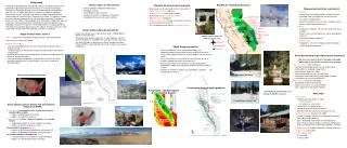
Scales of Sierra Nevada watersheds • Fewer than 20 main rivers, each of which drains 1,000-5,000 km2 above the mountain front • The greater San Joaquin (mountains & valley together) is on the order of 35,000 km2, or 50,000 km2 including the Tulare Lake basin • The Sierra Nevada, as defined in the Sierra Nevada Ecosystem Project (SNEP) is about 650 km long & 120 km wide, for an area of 80,000 km2 Background Following its GEO2000 plan, the National Science Foundation’s Geosciences Directorate is planning major new investments in research infrastructure. Through the Consortium of Universities for the Advancement of Hydrologic Sciences, Inc. (CUAHSI) NSF plans to establish a network of hydrologic observatories that will stimulate study where hydrologic & biogeochemical understanding of the water cycle is currently most limited. As argued in multiple consensus planning documents, the mountain West is perhaps the highest priority for such studies. Planning began in fall 2003 when a group from about 10 universities met to consider how the CUAHSI HO initiative could best serve hydrologic research in the greater semi-arid Southwest. The group agreed that THE distinctive hydrologic opportunity in the region is to make a mountain-range-scale study focused around the hydrology of the Sierra snowpack. Tahoe/Truckee American Cosumnes Mokelumne Stanislaus Tuolumne Merced San Joaquin Infrastructure intensive field research sites Tuolumne River Kings Kaweah headwater intermediate labs/sites Precipitation: 3 distinct regions along latitudinal gradient 1.5-2 m 1.2-1.5 m Tuolumne Meadows Marble Fork of the Kaweah 0.8-1.2 m Forest types along elevation gradients Central Sierra Snow Lab Sequoia Kings Canyon NP Kings River Exper. Watershed Sagehen Creek Field Station • Science topics for HO network • linking hydrologic & biogeochemical cycles • hydrologic extremes • sustainability of water resources • transport of chemical & biological contaminants • hydrologic influence on ecosystem functions Building on existing infrastructure • Thoughts on measurement approach • Make heavy use of automated, in-situ measurements: “faster, cheaper, more” approach • Use remote sensing data where feasible • Make heavy use of existing data/networks • Have a historical component • Deploy a combination of range-scale, basin-scale and smaller-catchment instruments • Insist on adequate investment in information systems • Measurement priorities: working list • Continuous • Ground-based hydrometeorology instrument clusters • Extended snow & soil moisture instrument cluster • Flux towers along gradients • Electrical conductivity, nitrate, silica in selected streams • Stream stage & groundwater levels • Periodic • Snowcover, snowpack, soil moisture (remote sensing & synoptic) • Stream, snow, rain, dry deposition, spring, groundwater chemistry • Something related to sediment • Characterization • Topography, soils, forest canopy, landcover, geology • LIDAR (vegetation properties) • Scope of observatory science • stimulate study where hydrologic & biogeochemical understanding of the • water cycle is currently most limited • facilitate research by: • measuring hydrologic phenomena over representative spatial scales & long time periods • creating a legacy of well-designed & documented long-term observations & experiments • providing baseline data & short-term process studies for conducting major synthesis & theoretical efforts • fostering emergent collaborations among scientists & decision makers • providing information for the identification, assessment & solution of societal problems • SNHO design parameters • Focus on hydrologic issues where breakthroughs are important/needed, resource/infrastructure limited & investments likely to attract good researchers, who will produce the breakthrough results • Focus investments in infrastructure & measurements, but serve multiple hydrologic questions & communities • Aim for representative measurements that will yield general knowledge as opposed to site-specific problem solving or unique systems • Variables to consider in design: e.g. precipitation, vegetation … vary with latitude & elevation • Sierra Nevada Hydrologic Observatory Community • We want to create a Sierra Nevada hydrologic observatory that will be a community resource. • What can we offer other colleagues: • historical spatial/temporal data sets for model testing • field facilities for campaigns/experiments • technical/field support for studies • well-characterized field sites for experiments • tested tools & techniques that you can apply elsewhere • seed money for research at the SNHO • What we want from those colleagues: • participation in observatory design • expression of interest in using the SNHO • their support for establishing the SNHO HO network will be nationwide Leveraging & partnerships are critical to SNHO success • Next steps • Prospectuses • 10-page report due August 1, 2004 • science questions • site attributes to recommend it • include URL’s for additional info • marketing document to fellow scientists • posted to CUAHSI website for community to read • National Workshop (August 24-25, 2004) • choose 5 “example” basins for hypothetical HO network from submitted prospectuses • Day 1: Politicking and election (reviewed by panel) • Day 2: Breakout groups by basin (core data composition) & by science topic (cross-observatory hypothesis testing) • Regional meetingsto build community: 5 during fall/winter • Proposals due: April 2005 • Select & initiate HO’s • 2 in late 2005 • 3 more in 2007 • Some specific science drivers that will influence design of an SNHO • Climate warmingperturbations on a climate system that is already highly variable: • patterns of precipitation & snowmelt • patterns of vegetative water use • Habitat restorationefforts – aquatic & riparian – in a variable climate • coupled groundwater & stream response to changes • patterns of nutrient spiraling in streams • The potential for long-termdroughts • patterns of rain/snowmelt partitioning, soil moisture, ET … • patterns of groundwater recharge, stream baseflow .. • Increasing potential for damage fromfloods • elevational patterns of changes in hydrometeorology • patterns of sediment generation & transport