Download
1 / 14
150 likes | 255 Vues
Explore the potential of big data and satellite imagery for forecasting snowmelt runoff in mountain rivers, aiding hydropower, agriculture, and city water management. Learn the evolution from historical data to advanced modeling tools, with current technology and community interest driving progress.

E N D
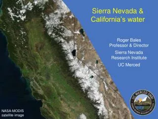
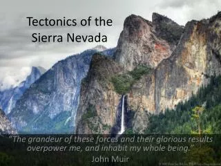
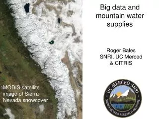
Big data and mountain water supplies Roger Bales SNRI, UC Merced & CITRIS MODIS satellite image of Sierra Nevada snowcover
Example: forecasting the amount & timing of spring/summer snowmelt runoff in mountain rivers Uses of data: hydropower scheduling, water allocations for agriculture & cities, dam operations, forest management, drought & flood planning Past : reliance on historical runoff data, measurements at a few index sites, statistical correlations Future: blending data from satellites, wireless sensor networks, advanced modeling tools Available now: technology, satellite data, prototype ground data, strong community interest Missing pieces: operational-quality wireless sensor networks, cyberinfrastructure to clean/integrate data & deliver custom information for decision support R. Bales
Water balance – fluxes Reservoirs: Snowpack storage Soil-water storage evapotranspiration precipitation Myths: We can, with a high degree of skill, estimate or predict the magnitude of these fluxes & reservoirs Better hydrologic modeling using existing data sources will yield significant improvement infiltration snowmelt sublimation streamflow ground & surface water exchange R. Bales
Example: forecasting the amount & timing of spring/summer snowmelt runoff in mountain rivers Uses of data: hydropower scheduling, water allocations for agriculture & cities, dam operations, forest management, drought & flood planning Past : reliance on historical runoff data, measurements at a few index sites, statistical correlations Future: blending data from satellites, wireless sensor networks, advanced modeling tools Available now: technology, satellite data, prototype ground data, strong community interest Missing pieces: operational-quality wireless sensor networks, cyberinfrastructure to clean/integrate data & deliver custom information for decision support R. Bales
TRENDS (1950-97) in April 1 snow-water content at western snow courses Knowles et al., 2006 Mote, 2003 -2.2 std devs LESS as snowfall +1 std dev MORE as snowfall Observed changes in water cycle go beyond historical levels less spring snowpack less snow more rain earlier snowmelt Combined stresses: Climate warming Landcover change Population pressures Stewart et al., 2005 R. Bales
Example: forecasting the amount & timing of spring/summer snowmelt runoff in mountain rivers Uses of data: hydropower scheduling, water allocations for agriculture & cities, dam operations, forest management, drought & flood planning Past : reliance on historical runoff data, measurements at a few index sites, statistical correlations Future: blending data from satellites, wireless sensor networks, advanced modeling tools Available now: technology, satellite data, prototype ground data, strong community interest Missing pieces: operational-quality wireless sensor networks, cyberinfrastructure to clean/integrate data & deliver custom information for decision support R. Bales
Seasonal water-supply forecasting – current Precipitation forecast Decision making Empirical & regression methods Volume forecasts Ground data R. Bales
Example: forecasting the amount & timing of spring/summer snowmelt runoff in mountain rivers Uses of data: hydropower scheduling, water allocations for agriculture & cities, dam operations, forest management, drought & flood planning Past : reliance on historical runoff data, measurements at a few index sites, statistical correlations Future: blending data from satellites, wireless sensor networks, advanced modeling tools Available now: technology, satellite data, prototype ground data, strong community interest Missing pieces: operational-quality wireless sensor networks, cyberinfrastructure to clean/integrate data & deliver custom information for decision support R. Bales
energy balance model vegetation topography soils pixel by pixel SWE & SCA SWE pixel by pixel runoff potential Time Energy balance modeling scheme data cube meteorological data snow precipitation solar longwave albedo vegetation t y x keep it simple – but not too simple! here is where the big data & information processing comes in R. Bales
Example: forecasting the amount & timing of spring/summer snowmelt runoff in mountain rivers Uses of data: hydropower scheduling, water allocations for agriculture & cities, dam operations, forest management, drought & flood planning Past : reliance on historical runoff data, measurements at a few index sites, statistical correlations Future: blending data from satellites, wireless sensor networks, advanced modeling tools Available now: technology, satellite data, prototype ground data, strong community interest Missing pieces: operational-quality wireless sensor networks, cyberinfrastructure to clean/integrate data & deliver custom information for decision support R. Bales
A new generation of integrated measurements low-cost sensors wireless sensor networks satellite snowcover lidar Process research & advanced modeling tools R. Bales
Example: forecasting the amount & timing of spring/summer snowmelt runoff in mountain rivers Uses of data: hydropower scheduling, water allocations for agriculture & cities, dam operations, forest management, drought & flood planning Past : reliance on historical runoff data, measurements at a few index sites, statistical correlations Future: blending data from satellites, wireless sensor networks, advanced modeling tools Available now: technology, satellite data, prototype ground data, strong community interest Missing pieces: operational-quality wireless sensor networks, cyberinfrastructure to clean/integrate data & deliver custom information for decision support R. Bales
Basin-wide deployment of hydrologic instrument clusters – American R. basin Strategically place low-cost sensors to get spatial estimates of snowcover, soil moisture & other water-balance components in progress Network & integrate these sensors into a single spatial instrument for water-balance measurements. R. Bales
Turning unknowns into knows through new water information systems Research support: NSF, NASA, CA-DWR, SCE, CITRIS R. Bales