Download

1 / 21
210 likes | 263 Vues
Discover the economic significance of trade routes used by the Abbasid Dynasty, Trans Saharan Trade, Silk Road, Indian Ocean, Swahili Coast, and more. Learn about key trading centers and their impact on global commerce.

E N D
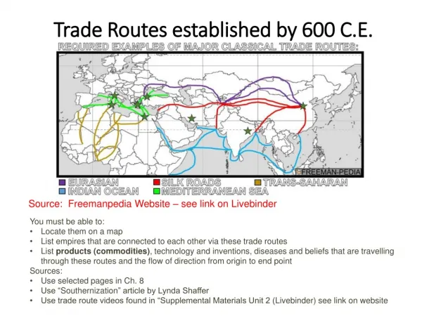
Trade routes assignment Daniel Schollie
Abbasid Dynasty • Used Baghdad, Cairo and Cordoba to stimulate trade and industry throughout the Islamic world • Created paper using Chinese methods • Created concept of Cheque (American Spelling, Originally Check) • Bazaars held goods from around the world for sale • Increased demand for materials within the Islamic empire, such as iron, leather and glass
Trans Saharan Trade • Outsiders rarely traded within the Sahara in early years • However, Locals used these North-West trade routes to sustain their cultures • Caravans of Islamic traders • Berbers • TRADED: GOLD, SALT, IVORY, POTTERY, SPICES, IRON GOODS, CAMELS, LINENS
Saharan trade routes circa 1400, with the modern territory of Niger highlighted
Darb el-Arbain Trade Route • Kharga and Asyut • Old Egyptian Kingdom • Romans • “Forty day road” • EXCHANGED: GOLD, IVORY, SPICES, WHEAT, ANIMALS, PLANTS
Trade Routes Focused around Carthage • Garamantes ---- c.1500 BCE • Phoenecia------- c. 400 BCE • Carthage (founded c. 800 BCE) • Middle men conducted trade • IMPORTED: SALT, CLOTH, BEADS, METAL GOODS • EXPORTED: GOLD (West African), IVORY, SLAVES
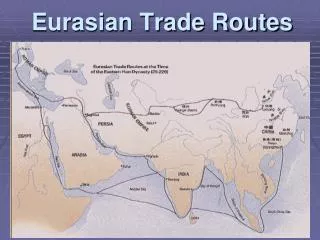
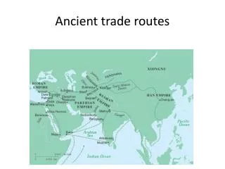
Silk Road Trade (map slide 8) • China Export: China, porcelain, Bronze ornaments, medicines, Spices, Perfumes, Chinese Inventions, Paper, Tea, Rice • China Import: Gold, Silver, Precious stones, Glass items, Hides, Wool, hunting dogs, Ivory, Turtle shells, Ceramics, Iron items, Mirrors
Indian Ocean • Gold, Ivory, Iron were all imported • Exported cotton, silk and porcelain • High demand for these exports due to low supply • Cities were easy to reach due to location and favourable winds and ocean currents • Cargo easy to load and unload at cities
Swahili Coast • Connected East, Central and South Africa to Indian/Pacific trade routes • Trade connected as far as Great Zimbabwe and modern day Democratic Republic of Congo • Slaves, Ivory major income providers • Currency, Pottery, Beads, Spices all imported
Great Zimbabwe • Bantu people founded Great Zimbabwe on their migration southward • Trade network linked with China and Kilwa • Gold, Ivory and Cattle were all believed to have been exported from Great Zimbabwe • Pottery, currency (from Arabia), glass beads all excavated suggesting these goods were imported
Timbuktu • Linked West Africa with Berbers, Arab and Jewish traders • Knowledge • On Niger River • Salt, Gold exported • Extremely Wealthy • Important Religious/Education site
Viking Trade • Traded in Constantinople silks and spices for slaves (usually Russian), Amber (from Baltic’s), furs, skins and walrus tusk ivory (from Iceland/Greenland/Norway etc.) • Founded Scandinavian trading cities of Birka, Ribe, Hedeby, and Skiringskal • Used Kiev (Ukraine) to open Russian and Byzantine trading goods to Western Europe • Stimulated large economic growth
Mediterranean Sea • Provided a way of trade, Colonization and war • Connected Ancient Greeks, Roman, Egyptians, Carthaginians and more • Later connected to Indian Ocean • Allowed for cultural exchange • Critical to development of Nations
Berenike • eastern side of Egypt • ideal position • India shipped goods here • Redistributed amongst people (particularly Romans around 100 BCE)
Dates Of Major Trading Centers • c. 200 BCE – 1300 CE Silk Road routes forming • c. 750 – 1258 CE Islamic Abbasid Dynasty • c. 1000 CE Crusaders acquire goods from middle East, become involved in world trade • c. 790 – 1070 CE Vikings become international traders, opening Russia to west trading
Bibliography • Oracle Education, ed. "Saharan Trade." LibraryThinkQuest. Web. 12 Dec. 2010. • Category, By. "The Trans-Saharan Gold Trade (7th14th Century) | Thematic Essay | Heilbrunn Timeline of Art History | The Metropolitan Museum of Art." The Metropolitan Museum of Art, New York: Metmuseum.org. Web. 12 Dec. 2010. <http://www.metmuseum.org/toah/hd/gold/hd_gold.htm>. • Masonen, Pekka. "Trans Saharan Trade and West African Discovery of the Mediterranean World." The Third Nordic Conference on Middle Eastern Studies. 19-22 June 1995. Web. 12 Dec. 2010. • "Silk Road - Trading Goods." Advantour: Tourism in Uzbekistan, Kazakhstan, Kyrgyzstan and Russia : Travel Guides. Web. 12 Dec. 2010. <http://www.advantour.com/silkroad/goods.htm>. • "Ancient India: Super Trade Center." Social Studies for Kids. Web. 13 Dec. 2010. <http://www.socialstudiesforkids.com/articles/archaeology/ancientindiatrade.htm>. • "Ancient Africa." Browse the World at Mrdowling.com. Web. 13 Dec. 2010. <http://www.mrdowling.com/609-test.htm>. • Category, By. "Great Zimbabwe (11th15th Century) | Thematic Essay | Heilbrunn Timeline of Art History | The Metropolitan Museum of Art." The Metropolitan Museum of Art, New York: Metmuseum.org. Web. 13 Dec. 2010. <http://www.metmuseum.org/toah/hd/zimb/hd_zimb.htm>. • Caputo, By Robert. "Swahili Coast @ Nationalgeographic.com." National Geographic Magazine. Web. 14 Dec. 2010. <http://ngm.nationalgeographic.com/ngm/data/2001/10/01/html/ft_20011001.6.html>. • "Image:Abbasid Caliphate and Fragmentation, 786 to 1194.jpg - QED." Main Page - QED. Web. 14 Dec. 2010. <https://qed.princeton.edu/index.php/User:Student/Abbasid_Caliphate_and_fragmentation,_786_to_1194>. • "Viking Trade." The Viking Network. Web. 14 Dec. 2010. <http://www.viking.no/e/travels/etrade.htm>. • "Islam, Abbasids, Zenith Of Islamic Civilization." Google. Web. 14 Dec. 2010. <http://webcache.googleusercontent.com/search?q=cache:MMpryfWG27gJ:history-world.org/islam9.htm Abbasid dynasty trade&cd=1&hl=en&ct=clnk&gl=ca>. • "The Indian Ocean Trade: Outreach Program." Boston University. Web. 15 Dec. 2010. <http://www.bu.edu/africa/outreach/materials/handouts/indian.html>. • "Islamic History: The Abbasid Dynasty - ReligionFacts." Religion, World Religions, Comparative Religion - Just the Facts on the World's Religions. Web. 15 Dec. 2010. <http://www.religionfacts.com/islam/history/abbasid.htm>. • "The Mediterranean Sea and The Gulf of Lyon." Languedoc Weather, Property, Holidays, Naturist Beaches, Wines, and Cathar Castles in the Languedoc-Roussillon, South of France. Web. 15 Dec. 2010. <http://www.languedoc-france.info/0716_mediterranean.htm>.