Download
1 / 16
160 likes | 183 Vues
Explore the UNCCD's efforts in monitoring land degradation, SDG indicator 15.3.1, methodologies, data collection, and next steps. Learn about sub-indicators: land cover, land productivity, and carbon stocks. Discover the agency's mandate, standards, and future plans.

E N D
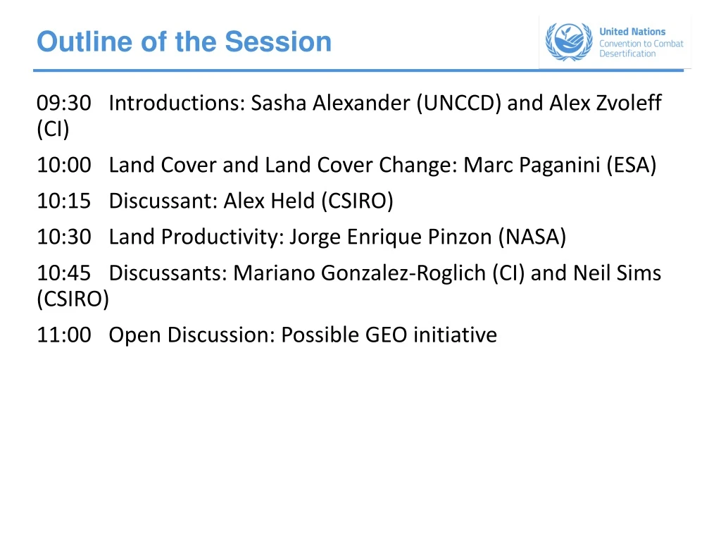
Outline of the Session 09:30 Introductions: Sasha Alexander (UNCCD) and Alex Zvoleff (CI) 10:00 Land Cover and Land Cover Change: Marc Paganini (ESA) 10:15 Discussant: Alex Held (CSIRO) 10:30 Land Productivity: Jorge Enrique Pinzon (NASA) 10:45 Discussants: Mariano Gonzalez-Roglich (CI) and Neil Sims (CSIRO) 11:00 Open Discussion: Possible GEO initiative
SDG indicator 15.3.1 Proportion of land that is degraded over total land area United Nations Convention to Combat Desertification (UNCCD) GEO Week Side Event 23 October 2017 Sasha Alexander, Policy Officer, UNCCD secretariat
Outline of the presentation • SDG target 15.3 and SDG indicator 15.3.1 • What is the UNCCD doing? • Mandate • Methods and guidelines • Standards and classification systems • Data collection and availability • Next steps and GEO potential involvement
SDG indicator 15.3.1 Proportion of land that is degraded over total land area Sub-Indicators • Land cover • Land Productivity • Carbon stocks (assessed as SOC) These 3 sub-indicators: • were adopted by the UNCCD’s governing body (the COP) in 2013 • are also Essential Climate Variable (ECV)
SDG indicator 15.3.1 Proportion of land that is degraded over total land area The indicator is estimated by summing all areas subject to “negative” change (i.e., degraded) in one of the sub-indicators and dividing by the total land area “One Out, All Out” area-based approach
UNCCD’s mandate The UNCCD is the custodian agency for SDG indicator 15.3.1 The UNCCD leads an Inter-Agency Advisory Group on indicator 15.3.1 composed of FAO, CBD, UNFCCC, UNEP and UNSD to further refine the methodology and data tools/options In Sept. 2017, the UNCCD COP requested the secretariat, as the custodian agency for SDG indicator 15.3.1, to: • use the information submitted by Parties in national reports as a contribution to the overall follow-up and review of the 2030 Agenda • continue to cooperate with relevant organizations in the development of methodologies and capacity building approaches for reporting In 2015, the UNCCD COP also requested the secretariat, in cooperation with relevant specialized institutions, to: • Compile and make available to Parties national estimates of the sub-indicators from available global datasets as default data • Prepare methodological guidelines and provide technical assistance to Parties • Undertake measures aimed at strengthening the capacities of Parties
Methods and guidelines A scientific conceptual framework for Land Degradation Neutralityunderpins a universal methodology for deriving SDG indicator 15.3.1. It was endorsed by the UNCCD’s COP in September 2017 Available at: http://www2.unccd.int/sites/default/files/documents/2017-08/LDN_CF_report_web-english.pdf
Methods and guidelines • Good Practice Guidance (GPG) is now being finalized based on the established methods for deriving the three sub-indicators together with a method of computation for SDG indicator 15.3.1 • GPG is intended to allow countries to select the most appropriate datasets for the sub-indicators and determine their own pathway for deriving the indicator • Significant negative change (i.e., land degradation) is to be determined by national authorities • External review and consultation with the IAEG-SDGs Working Group on Geospatial Information (including GEO/CEOS), NSOs/countries (CEEA/GGIM) and other stakeholders.
Standards & Classifications systems • Land Cover: ISO-19144-2:2012, specifies a Land Cover Meta Language that allows different land cover classification systems to be described based on the physiognomic aspects • LPD: - planned • SOC: Considering ISO • Metadata: ISO-19115-1:2014, defines the schema required for describing geographic information and services by means of metadata
Data Collection & Availability National official data sources will be used to the greatest extent possible, and complemented by data derived from Earth observation and geospatial information with availability back to at least 2000 Default data will be sent to national teams or focal points to be shared and validated with NSOs and then reported back to the UNCCD ESA Climate Change Initiative Land Cover JRC Land Productivity Dynamics ISRIC SoilGrids250m
Current status of implementation • Out of the 113 countries that have committed to set LDN targets, 64 countries have already established a baseline
Next steps • Upgrade to Tier 2 up for discussion at IAEG-SDG meeting in November • Next UNCCD reporting in 2018, and then every 4 years results will feed into SDG reporting • Methodology: further development of standards • Data still large and complex: lack of necessary expertise, particularly in developing countries, to access, prepare, process, and utilize raw space-based data. Need for analysis-ready data and capacity building • Moderate resolution is an issue, especially in mountainous regions, small island states and highly fragmented landscapes. Need to move to higher resolution datasets (10-30m) • Reliable consistent product with well defined accuracy and quality at national level (aiming at 92% confidence levels) • Data and application API and open web map services • Development of validation tools
Possible GEO initiative In September 2017, the UNCCD Conference of the Parties: • “Invites the Group on Earth Observation to support UNCCD Parties’ efforts at implementation of the Convention by providing space-based information and in situ measurements to assist countries in fulfilling the reporting requirements for Sustainable Development Goal indicator 15.3.1, and fostering data access, national data capacity-building and the development of standards and protocols”
Possible GEO Initiative UNCCD regional capacity building workshops: Rapid deployment would involve preparing curriculum and conducting training sessions to support countries in preparing and submitting their UNCCD national reports These 3-day workshops are tentatively scheduled February and March 2018 (India, Brazil, Grenada, Samoa, Moldova, Cameroon , and Egypt or Lebanon). • Facilitate access to space-based information and in situ measurements for the three sub-indicators; • Provide advice, tools and training to build national capacities Federated collaborative platforms: with high computing capacities and big data analytics tools for countries to easily select, access, process, analyze, interpret and quality control large datasets associated with EO and geospatial information; and to host initial global consultations, perhaps in late 2018, to help advance progress on developing international standards and protocols .
Possible GEO Initiative GEO members: China*, India*, Brazil*, Mexico*, South Africa*, Japan, Canada, Australia, European Commission, USA GEO participating organizations: UNCCD, GEF**, JRC**, CI**, FAO**, GCOS, UNOOSA, EEA, CEOS CEOS members: ESA**, NASA**, JAXA, ISRO, INPE, CSA, CSIRO**, SANSA * UNCCD LDN-TSP participating countries** UNCCD partners on methodology and data delivery