Utilizing SSES for Enhanced Satellite Data Accuracy in GOES Retrievals
60 likes | 194 Vues
This research explores the use of SSES (Satellite System Estimation System) to refine the accuracy of GOES L2P (Level 2 Product) retrievals. By integrating additional information that cannot be derived from ancillary data alone, we analyze how retrieval bias correlates with clear-sky transmittance and air-sea temperature differences. Our findings suggest that the sensitivity to air-sea temperature variations increases as transmittance decreases, leading to a derived bias model based on offset and gradient terms. The results highlight the importance of considering these factors in accurate satellite data interpretation.

Utilizing SSES for Enhanced Satellite Data Accuracy in GOES Retrievals
E N D
Presentation Transcript
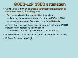
GOES-L2P SSES estimation • Using SSES to provide additional information that cannot be calculated from L2P ancillary data • 1st cut assumption is that retrieval bias depends on • Clear-sky transmittance (calculated from NCEP → CRTM) • Air-sea temperature difference (currently NCEP only) • Assume that sensitivity to Air-Sea Temperature Difference (ASTD) increases with decreasing transmittance • Derive bias = offset + gradientASTD for different 11 • Post-corrected σ is estimated as a function of transmittance only • Different for sensor/day/night
GOES-10 Offset termGradient termStd. Dev. term
GOES-12 Offset termGradient termStd. Dev. term
GOES-12 L2P N. Hem Mar 25 16:45 GOES-12 L2P N. Hem Mar 28 15:15 GOES-12 L2P N. Hem Mar 28 15:15 GOES-12 L2P N. Hem Mar 25 16:45