Download
1 / 17
170 likes | 301 Vues
The innovative MapAdapt system integrates a portable Wiki-based platform with a real-time GIS server, allowing for seamless collaboration in environmental data sharing. Developed by experts at Texas A&M University-Corpus Christi, this system offers easy installation and accessibility for users with varying levels of GIS expertise. It supports multiple flavors, including MapServer, ArcIMS, and Google Maps, ensuring flexibility in applications such as geomatics and hydrographic science. Experience straightforward data management in emergency situations with this robust solution.

E N D
Portable wiki map server and real time environmental MySQL GIS server • Stacey Lyle, PhD, RPLS Associate Professor of Geographic Information Science • Gary Jeffress, PhD, RPLS Professor of Geographic Information Science Conrad Blucher Institute for Surveying and Science Texas A&M University-Corpus Christi • Richard Smith, Visiting Professor Of Geographic Information Science
Academic Programs • BS in Geographic Information Science, ABET accredited • Emphasis in Geomatics (surveying and mapping) • Emphasis in GIS • Emphasis in Hydrographic Science (sea floor mapping) proposed • MS in Geospatial Surveying Engineering • Online program (one week per semester on campus) • http://gisc.tamucc.edu/
Wiki-based system for collaborative creation and maintenance of websites • Authored by Patrick Michaud, PhD of Texas A&M University – Corpus Christi • PmWiki featured in INC Magazine 2006 as the best free/Open Source Wiki web server • Easy install. Download, uncompress -> installed
How Works for End User • PmWiki pages look and act like normal web pages, except they have an "Edit" link that makes it easy to modify existing pages and add new pages into the website, using basic editing rules. You do not need to know or use any HTML or CSS. Page editing can be left open to the public or restricted to small groups of authors. • Extensive “Cookbooks” available at pmwiki.org • Active community • Hundreds of recipes
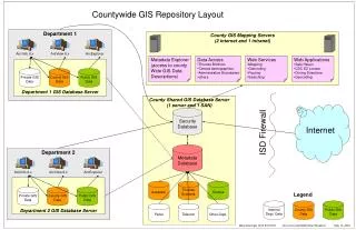
MapAdapt • NASA SBIR created a realtime GIS server that shared enviornmental data. • NASA required server to share data with multiple users at dispirate levels of GIS/computer expertise • Wrapped PmWiki around map servers • maintained simplicity for inexperienced users • provided advanced functionality for advanced users
MapAdapt Portability • Designed to be run from a flash drive • Runs all technology required for MapServer and PmWiki locally without installation • Users simply run a batch file and the website is up and running • Provides quick, simple roll-out in emergency situations across multiple types of hardware
MapAdapt Flavors • MapAdapt MapServer(UMn): • Allows you to build a MapServer with PmWiki • MapAdapt ArcIMS: • Allows you to Mashup ArcIMS wraped with PmWiki • MapAdapt WMS: • Allows you to Mashup Openlayers with PmWiki • PmWiki Google Maps • Allows you to embed Google Maps in PmWiki
TCOON Users Hurricane Ike Hurricane Dolly