Download
1 / 36
360 likes | 577 Vues
Earthquake and Tsunami Education Program for Coastal Cascadia Stakeholders Meeting June 21, 2011 Hatfield Marine Science Center, Newport, Oregon. Teachers on the Leading Edge. www.earthscope.org. http://orgs.up.edu/totle/. Cascadia Education and Outreach. Cascadia Science. Scientists.

E N D
Earthquake and Tsunami Education Program for Coastal Cascadia Stakeholders Meeting June 21, 2011 Hatfield Marine Science Center, Newport, Oregon Teachers on the Leading Edge www.earthscope.org http://orgs.up.edu/totle/
Cascadia Education and Outreach Cascadia Science Scientists Training Colleges & Universities Formal Learning Free-Choice Learning Educators Teachers Interpreters Parks & Museums Community Progams K-12 TOTLE EarthScope E&O Emergency Management Students The Public Scientific Discoveries and their Meanings
Cascadia Education and Outreach Cascadia Science Scientists Formal Learning Free-Choice Learning Not: “Dumbing It Down” Students The Public Cascadia Discoveries and their Meanings
Cascadia Education and Outreach Scientific Discoveries and their Meanings Students The Public Rather:“Storying It Up” Formal Learning Free-Choice Learning Scientists Cascadia Science
Beauty and the Beast “The same geological processes that create Oregon’s breathtaking headlands and beaches also threaten our lives with devastating earthquakes and tsunamis.” Robert J. Lillie Marine Gardens - Otter Crest, Oregon
Cascadia Education and Outreach Scientific Discoveries and their Meanings Students The Public Emergency Management K-12 TOTLE EarthScope E&O Parks & Museums Community Programs Teachers Interpreters Educators Formal Learning Free-Choice Learning Colleges & Universities Training Scientists “Storying it Up!” Cascadia Science
Coastal Cascadia Earthquake and Tsunami Education and Preparedness Scientific Discoveries and their Meanings Students The Public Emergency Managers K-12 Parks & Museums Educators Park Interpreters K-12 Teachers Formal Learning Free-Choice Learning Colleges & Universities Training Scientists Cascadia Earthquake/Tsunami Education and Preparedness Team “Storying it Up!” Cascadia Science
June 21 Stakeholders Meeting • Earthquake and Tsunami Education Program for Coastal Cascadia • 10:00 AM • Welcome and Introductions, Bob Lillie • Short Presentations: • Bob Butler: Cascadia Earthquakes and Tsunamis Education in K-12 Earth Science • Bob Lillie: EarthScope Education in Parks • Rob Witter: Comparing Cascadia and Japan, the Preparedness Challenge • Beth Pratt-Sitaula, Bob Butler, Bob Lillie: Preliminary Thoughts on Earthquake/Tsunami Education Program Design • Morning Brainstorming • 12:00 Noon Lunch provided at HMSC • 12:30 – 2:00 • Breakout Sessions, Beth Pratt-Sitaula • K-12 Educators • Parks Interpreters • Emergency Managers • Assignments to groups: • 1. What does your group want from an Earthquake and Tsunami Education Program for • Coastal Cascadia? • 2. What can your group contribute to the program? • 3. What logistical realities need to be considered?. • 4. What should we know about existing resources, and what new resources does your group need? • 2:00 – 2:30 PM • Reports from Groups • 2:30 – 4:00 PM • Discussion on design and logistics of the Earthquake and Tsunami Education Program • for Coastal Cascadia. • Outlining the Proposal to NSF EarthScope Program
Earthquake and Tsunami Education Program for Coastal Cascadia Stakeholders Meeting, June 21, 2011 EarthScope in Cascadia Bob Lillie EarthScope Education and Outreach ManagerEarthScope National Office Oregon State University www.earthscope.org
EarthScope Drillhole across San Andreas Fault 875 GPS Instruments 175 Borehole Strainmeters 5 Long-Baseline Laser Strainmeters 400 Seismometers at 2,000 sites 100 Permanent Seismometers EarthScope • A nationwide effort to ….. • Explore the structure and evolution of North American continent • Study processes that cause earthquakes and volcanic eruptions • EarthScope has three main “observatories” …..
EarthScope Observatories USArray Seismometers Geodetic Instruments Deep Drillhole PBO SAFOD Plate Boundary Observatory San Andreas Fault Observatory at Depth
USArray Observatories • USArray: • Includes 400 Transportable Seismometers • Each station occupies a site for 1½ to 2 years • 10 years to leap-frog across the country IRIS (Incorporated Research Institutions for Seismology) Washington, DC http://anf.ucsd.edu/stations/deployment_history.php
EarthScope Like a “Hubble Telescope” aimed into the Earth
Seismic Tomography “CatScan” of the Earth P-Wave “Community Velocity Model” based partly on USArray through November 2007 High Velocity (Blue): - Eastern U. S. - Subducted Juan de Fuca (JdF) and Farallon plates Cold Waves Speed Up Low Velocity (Red): - Basin and Range Province (B&R) - Yellowstone Hotspot (YH) Hot Waves Slow Down Burdick and others, 2008
PBO Plate Boundary Observatory Observatories • GPS Instruments • Strainmeters UNAVCO Boulder, CO GSP Station California State University at San Bernardino
Cascadia Subduction Zone -- Locked and Loaded • Western Oregon and Washington are being pushed toward the northwest. • The region is “stuck” to the Juan de Fuca Plate ….. Neah Bay Pacific Beach Tumwater Othello Kelso Tillamook Wasco La Grande Newport Corvallis Newport GPS Station (Modified from Bob Butler, University of Portland)
GPS Stations Monitor Ground Motion GPS Stations Modified from Geological Survey of Canada
“Locked” Subduction Zone Stations in western Oregon moving upward and NNE Stations in eastern Oregon not moving ~ 200 – 600 Years Modified from Geological Survey of Canada
Suddenly Unlocks!! Coastal areas abruptly drop down! Tsunami ~ 3 – 4 Minutes!! Earthquake Modified from Geological Survey of Canada
Targeted EarthScope Experiments along Cascadia Subuduction Zone CAFÉ: Cascadia Arrays For EarthScope. Seismologists deployed a network of 60 seismometers (2006) that covered much of western Washington to study how the Cascadia subduction system works. FACES: Flexarray Along Cascadia Experiment for Segmentation. A deployment of 20+ broadband seismic sensors in western Oregon and Washington with the goal of resolving structural controls on episodic tremor and slip all along Cascadia. COLZA: Central Oregon Locked Zone Array. An amphibious array of 16 ocean bottom seismometers (2007-2009) and 6 onshore FlexArray stations to better constrain seismicity of the central Oregon part of the Cascadia subduction zone. MENDO: Mendocino Experiment. Used a dense array of broadband seismographs (2007-2009) to investigate the structure of the Mendocino Triple Junction, the northernmost terminus of the San Andreas Fault. http://www.earthscope.org/science/field_programs
Earth Science Literacy Principles http://www.earthscienceliteracy.org 1. Earth scientists use repeatable observations and testable ideas to understand and explain our planet. 2. Earth is 4.6 billion years old. 3. Earth is a complex system of interacting rock, water, air, and life. 4. Earth is continuously changing. 5. Earth is the water planet. 6. Life evolves on a dynamic Earth and continuously modifies Earth. 7. Humans depend on Earth for resources. 8. Natural hazards pose risks to humans. 9. Humans significantly alter the Earth. Big Ideas:
National Parklands Drillhole across San Andreas Fault 875 GPS Instruments 175 Borehole Strainmeters 5 Long-Baseline Laser Strainmeters 400 Seismometers at 2,000 sites 100 Permanent Seismometers Informal Education Workshops For Interpretive Professionals in Parks and Museums Monitoring the Dynamic Landscape Enhances our “Sense of Place”
Drillhole across San Andreas Fault 875 GPS Instruments 175 Borehole Strainmeters 5 Long-Baseline Laser Strainmeters 400 Seismometers at 2,000 sites 100 Permanent Seismometers Informal Education Workshops For Interpretive Professionals in Parks and Museums Monitoring the Dynamic Landscape Enhances our “Sense of Place” • 1. Cascadia Subduction Zone • Mt. Rainier National Park • April 7–10, 2008 www.earthscope.org/eno/parks
Drillhole across San Andreas Fault 875 GPS Instruments 175 Borehole Strainmeters 5 Long-Baseline Laser Strainmeters 400 Seismometers at 2,000 sites 100 Permanent Seismometers Informal Education Workshops For Interpretive Professionals in Parks and Museums • 6. New Madrid - Central U. S. • March 17-20, 2011 • 200th Anniversary of Big Earthquakes • USArray Rolling across the Midwest …. www.earthscope.org/eno/parks
Active Earth Display Real-time display designed for visitor centers and museums Developing regional modules by “tectonic setting” Cascadia Basin and Range Province San Andreas Joint effort of IRIS, UNAVCO, and EarthScope Highlighted as part of EarthScope Informal Education Workshops Proposal Process Six awarded as result of workshops IRIS Active Earth Display www.iris.washington.edu/hq/programs/education_and_outreach/museum_displays/active_earth
Drillhole across San Andreas Fault 875 GPS Instruments 175 Borehole Strainmeters 5 Long-Baseline Laser Strainmeters 400 Seismometers at 2,000 sites 100 Permanent Seismometers IRIS Active Earth Display Placement of IRIS Active Earth Kiosks in Parks and Museums 2. Oregon Paleo Lands Institute 1. Oregon Whale Watching Center 4. Montana Mineral Museum 3. Redwood National and State Parks 5. San Bernardino County Museum 6. Anza-Borrego Desert State Park www.iris.washington.edu/hq/programs/education_and_outreach/museum_displays/active_earth
IRIS Active Earth Display www.iris.edu/aed2/index.phtml?code=cascadia Cascadia Module
Whale Watching Center Depoe Bay, Oregon 4 People killed by 1964 Great Alaska Earthquake Tsunami Robert J. Lillie Beverly Beach State Park, Oregon
Robert J. Lillie Whale Watching Center, Depoe Bay, Oregon
Whale Watching Center, Depoe Bay, Oregon Robert J. Lillie
Robert J. Lillie Whale Watching Center, Depoe Bay, Oregon
Whale Watching Center, Depoe Bay, Oregon Ranger Morris Grover Robert J. Lillie
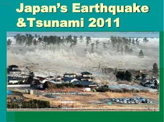
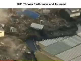
Are We Prepared? Modified from Pat Corcoran, OSU Extension Research has only in the past 25 years revealed that Cascadia has “Gi-normous” earthquakes and accompanying tsunamis. We must be better prepared ……
Beauty and the Beast “The same geological processes that create Oregon’s breathtaking headlands and beaches also threaten our lives with devastating earthquakes and tsunamis.” Robert J. Lillie Marine Gardens - Otter Crest, Oregon
Coastal Cascadia Earthquake and Tsunami Education and Preparedness Scientific Discoveries and their Meanings Students The Public Emergency Managers K-12 Parks & Museums Educators Park Interpreters K-12 Teachers Formal Learning Free-Choice Learning Colleges & Universities Training Scientists Cascadia Earthquake/Tsunami Education and Preparedness Team “Storying it Up!” Cascadia Science