Building Hydrologic Information Systems
580 likes | 700 Vues
Explore the Arc Hydro framework, an ArcGIS-based data model, and tools that facilitate comprehensive modeling and analysis of hydrologic data. Learn how this system supports decision-making for water resources management and planning.

Building Hydrologic Information Systems
E N D
Presentation Transcript
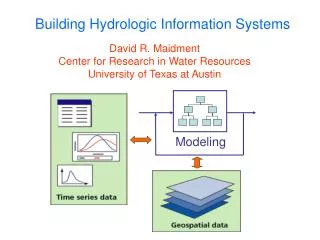
Building Hydrologic Information Systems David R. Maidment Center for Research in Water Resources University of Texas at Austin Modeling
Modeling Hydrologic Information System A combination of geospatial and temporal hydrologic information which supports analysis, modeling and decision making
Streamflow Information in Space and Time Current Future Possibilities Time Real Time data Historical daily mean discharge Streamstats Streamflow statistics At Gages Anywhere on a Stream Space
Arc Hydro An ArcGIS data model for water resources Arc Hydro toolset for implementation Framework for linking hydrologic simulation models Arc Hydro: GIS for Water Resources The Arc Hydro data model and application tools are in the public domain
GIS in Water Resources Discipline “Follow a drop of water from where it falls on the land, to the stream, and all the way to the ocean.” R.M. Hirsch, USGS
Bringing together these two communities by using a common geospatial data model CRWR GIS CRWR GIS in Water Resources Consortium Water Resources
Arc Hydro Framework Input Data Watersheds Waterbody Streams Hydro Points
Arc Hydro Framework Data Model
Arc Hydro Framework For South Florida Basins Waterbody (NHD) Hydro Points National Hydrography Dataset, NHD
Drainage System Hydro Network Flow Time Time Series Hydrography Channel System Arc Hydro Components
GIS Preprocessors for Hydrologic Models GIS Interface Model 1 Database Model 2 Model 3
Connecting Arc Hydro and Hydrologic Models GIS Interfacedata models HMS Geo Database Arc Hydro data model RAS WRAP
Regional Storm Water Modeling Program and Master Plan for San Antonio City of San Antonio
San Antonio Regional Watershed Modeling System Geospatial Data: City, County SARA, other “Bring the models together” Modeling System Rainfall Data: Rain gages Nexrad Calibration Data: Flows Water Quality Floodplain Management Capital Improvement Planning Water quality planning Integrated Regional Water Resources planning Flood Forecasting
Regional Watershed Modeling System Case Study Salado Creek watershed Components: • Arc HydroGeodatabase • for whole watershed • HEC-HMShydrology model • for whole watershed • HEC-RAShydraulic model • for Rosillo Creek Bexar County Rosillo Creekwatershed
Arc Hydro and HEC-HMS HEC-HMS Hydrologic Model Arc Hydro Schematic Network Calculates Flows
Arc Hydro and HEC-RAS HEC-RAS Hydraulic Model Calculates Water Surface Elevations Arc Hydro Channel Cross Sections
Flow Change Points Models communicate with one another through Arc Hydro at designated points
FLOODPLAIN MAP Nexrad Map to Flood Map in Arc 9 Model Builder Flood map as output Model for flood flow HMS Model for flood depth Nexrad rainfall map as input
Fecal Coliform in Galveston Bay(Monthly data, 1995-2001) Coliform Units per 100 ml Tracking Analyst Demo
Water Availability • 1996 Texas drought • Governor Bush asks “how much water do we have? How much are we using? How much do we need?” -- Ooops. No good answers! • 1997 Senate Bill 1 passed by Legislature • Regionalizes water planning in Texas and establishes surface water availability modeling • 2001 Senate Bill 2 passed by Legislature • Establishes groundwater availability modeling and initiates instream flow assessment
Improvements from Senate Bill 1:Water Modeling and Planning • Before Senate Bill 1, water planning was done state-wide by TWDB • SB1 established 14 water planning regional groups, who are now responsible for planning water supply in their area Water Availability Modeling (TNRCC)
1° 7.5' 7.5' Improvements from Senate Bill 1:Digital Map of Texas: 100K → 24K 1° Quadrangles 1:100,000 scale Approx. 100 maps cover Texas 1° 7.5' Quadrangles 1:24,000 scale 4400 maps cover Texas
Improvements from Senate Bill 1: Water Availability Modeling Sulphur Brazos Trinity 8000 water right locations Colorado 23 main river basins Rio Grande City of Austin Nueces Inform every permit holder of the degree of reliability of their withdrawal during drought conditions (TCEQ)
CRWR Mission for Senate Bill 1 • CRWR (UT Austin) aids in the response to Senate Bill 1 by providing to TNRCC watershed parameters defined from geospatial data for each water right location • These data are input by TCEQ contractors to a Water Rights Assessment Package (developed at TAMU) which determines the % chance that the water will actually be available at that location • TCEQ sends theownerof the water right a letter specifying the availability of water
Water Rights in the Sulphur Basin Water right location Stream gage location Drainage areas delineated from Digital Elevation Models are used to estimate flow at water right locations based on flow at stream gage locations
90 72 95 76 85 80 75 90 83 89 81 73 72 83 85 80 82 70 89 87 Digital Elevation Model 75 77 79 85 92
Topographic Map of West Austin1:24,000 scale Hog Pen Ck 4 km 4 km
Digital Elevation Model (DEM) 720 720 Contours 740 720 700 680 740 720 700 680
Cell Size 30m 100m
32 64 128 16 1 8 4 2 Eight Direction Pour Point Model Water flows in the direction ofsteepest descent
32 64 128 16 1 8 4 2 Flow Direction Grid
Stream cell Cell to Cell Grid Network Through the Landscape
Comparison of Drainage Areas DEM Difference is ~ 0.5% USGS
Watershed Properties Averaged over the Drainage Area + Property grid (CN or Precipitation) Drainage Areas
Connectivity of the Control Points Neches Basin This flow order is used in the Water Rights Analysis Package
Data Products GIS coverages for determining watershed parameters Watershed parameters as input for WRAP model = Analysis completed for more than 10,000 locations in all river basins of Texas
Improvements from Senate Bill 2:Instream Flow requirements • Requires TPWD, TWDB, TCEQ to develop procedures for defining instream flow requirements • Implemented on priority study regions by 2010 • Based on fish habitat analysis Trinity Brazos Sabine Guadalupe San Antonio Priority Study Regions
Criterion Depth & velocity Species groups Habitat Hydrodynamic Habitat SMS/RMA2 Data Collection and some statistics Model Model Descriptions ArcGIS Instream Flow DecisionMaking Process Flowchart
Study Area (Guadalupe river near Seguin, TX) 1/2 meter Digital Ortho Photography
Depth Sounder (Echo Sounder) The electronic depth sounder operates in a similar way to radar It sends out an electronic pulse which echoes back from the bed. The echo is timed electronically and transposed into a reading of the depth of water.
Acoustic Doppler Current Profiler Provides full profiles of water current speed and direction in the ocean, rivers, and lakes. Also used for discharge, scour and river bed topography.
Measurement System GPS Antenna Computer and power setup Depth Sounder