Earth's Atmosphere-Ocean Interaction Insights
Explore the dynamics between Earth's atmosphere and oceans in this engaging schedule. From ocean currents to climate effects, dive into atmospheric and oceanic interactions to deepen your understanding of environmental systems. Don't miss key upcoming events and detailed examples to enhance your knowledge.

Earth's Atmosphere-Ocean Interaction Insights
E N D
Presentation Transcript
Upcoming Schedule • Friday, March 9: finish Chapter 10. • March 12-16, Spring Break. • Monday, March 19: Chapter 18 (Air Pollution). • Wednesday, March 21: begin Chapter 11 + office hours • Friday, March 23: no class (KM out of town). • Monday, March 26: Second midterm exam. The exam will cover Chapters 6, 7, 8, 9, 10 and 18. • Closed book • No textbooks, calculators or cheatsheets. • Alternate (anti-social) seating • Bring a picture ID to the exam. • Remember to: • Write the 5-digit test code in lines 76-80 • Write your name on the exam sheet and sign it • Turn in both the exam sheet and the answer sheet. • Wednesday, March 28: no class (KM out of town). • Friday, March 30: finish Chapter 11.
The Three Cell Model • Keep two of the assumptions, relax the third: • The Earth is covered with a continuous ocean • The sun is always directly over the equator • The Earth rotates -> Coriolis force!
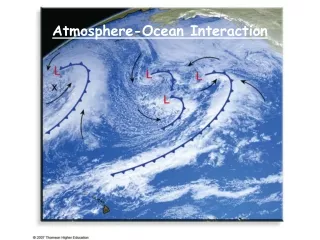
Does it work? • Yes: semi-permanent highs and lows: persist throughout the year • No: seasonal highs and lows (continents heat/cool faster) • No: seasonal shifts N-S (today) • No: winds aloft in mid latitudes January July Subtropical highs Subtropical highs
Effect on the local climate • During summer, the Pacific high moves north near the CA coast, and the Bermuda high moves closer to the SE coast. • CA: dry summers • GA: wet summers
Seasonal Effects on the Global Circulation. January • The three cell model neglects the Earth’s tilt • The tilt would cause seasonal N-S shifts • Bright white colors correspond to stronger winds. • The winds are stronger in the winter. • The wind system shifts slightly north-south during the year (think of bird migration) July
The General Circulation and Precipitation Paterns Timbo • Converging surface flows: • Low surface pressure • Uprising air • Heavy precipitation • Diverging surface flows: • High surface pressure • Sinking air • Dry climate • Seasonal variations of the climate. Example: Timbo, Guinea (Chapter 17).
Example: Tropical wet-and-dry climate (Aw) • Timbo (Guinea) • Wet summer season • Dry season (Dec-Feb): hot, desert-like conditions Grassland savanna
Winds and Pressure Systems Aloft • The wind system aloft differs from the surface wind system. It is close to a geostrophic flow. • There is no significant friction with the ground. • The three cell model does not work that well in the middle latitudes. • The winds aloft are stronger than on the ground. • In the winter the gradients are bigger -> the winds are stronger. July January
Jet Streams • Swiftly flowing air currents aloft • Tropopause jets • Subtropical: 13km high, 30N • Polar: 10km high, 60N • Strong westward winds • Meandering pattern • They result from strong temperature gradients at those latitudes (hence strong PG forces)
Tropopause jet streams • Discontinuous. Position varies daily. • May merge or split (northern and southern branches) • Meandering pattern: may flow to the north or south • Important for the global heat redistribution • Affect local weather conditions
Example: Polar Night Stratospheric Jet • The stratosphere is heated by ozone absorption of solar UV. • During the polar night the polar region is not illuminated and the stratosphere cools down. • This results in a big temperature contrast => pressure gradient. • Strong westerly winds at elevation 50 km.
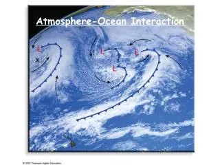
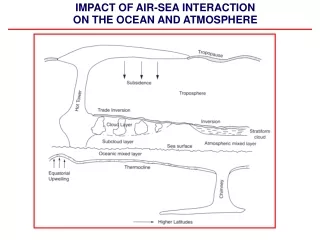
Atmosphere-Ocean Interaction • The surface of the Earth impacts the air motion through the friction force. • Newton’s III law: for every action there is a reaction. The atmosphere exerts a friction (drag) force on the surface of the Earth. • The prevailing surface winds drive the surface currents in the oceans. • Variations in the surface temperature of the ocean impacts the atmospheric T as well as amount of the water vapor in the atmosphere.
Major ocean currents • Gyres: circular whirls of ocean currents • 25-40 deg angle b/n wind and current • Clockwise in the North Pacific and Atlantic
Ekman Spiral • The surface winds drive the surface currents. • The friction force acting on the ocean surface is in the direction of the wind. • The Coriolis force deflects the current to the right (NH). • Each layer of water drags the water layer below, and the Coriolis force pushes the moving water below to the right. • The direction of the ocean current changes with depth. • The net mass transport within the first 100 m is perpendicular to the wind direction.
Upwelling of the Ocean Water • Winds plowing along the coastal line result in a net surface current perpendicular to the wind and away from the coast. • The warm surface water is replaced by an upwelling deep cold water. • Water upwelling explains the low water temperatures along the California coast.
Surface Water Temperature Along California’s Coast • The low water temperatures result in low saturation vapor pressure over the ocean. • Recall the advection fog example from Chapter 5 • As the air moves over the land the air warms up and results in low relative humidity. • The summer is very dry.
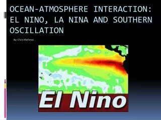
Pacific Ocean: normal conditions • Easterly winds drive ocean water upwelling along the coast of Peru -> cold, nutrient rich surface water, anchovies, bird droppings, fertilizers • The high surface pressure in the east Pacific is a location of a subsiding cold dry air. • In the west Pacific the low surface pressure is associated with upward air motion of warm and moist air. This results in plenty of precipitations and storms.
Pacific Ocean: El Nino conditions • An abnormally long warming event in the Pacific ocean – several months. • The easterlies are weak or even can become westerlies. This drives a strong counter current (to the east) in the ocean. The upwelling along the Peru coast is suppressed. • The low pressure center in the west is now a high pressure center-> sinking cold dry air over Indonesia. • The high pressure center in the east pacific is now low pressure center bringing a lot of rain and storms to the west coast of South America.
Southern Oscillations • A periodic reversal of the pressure pattern in the Pacific ocean. • It is associated with the propagation of a large scale wave (Kelvin wave) in the equatorial region. • ENSO=El Nino + Southern Oscillation
El Nina • An event of unusually strong easterly winds -> strong upwelling • The cold water spreads much farther westward El Nina El Nino