Download
1 / 1
10 likes | 94 Vues
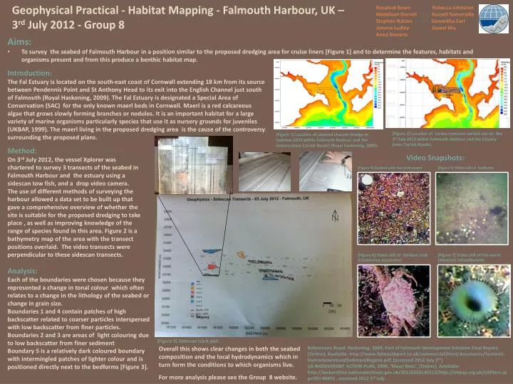
Geophysical Practical - Habitat Mapping - Falmouth Harbour, UK – 3 rd July 2012 - Group 8. Rosalind Bown Rebecca Johnston Maddison Dorrell Russell Somerville Stephen Nation Samantha Earl Jemma Ludley Jiawei Wu Anna Stevens. Aims:

E N D
Geophysical Practical - Habitat Mapping - Falmouth Harbour, UK – 3rd July 2012 - Group 8 Rosalind Bown Rebecca Johnston Maddison Dorrell Russell Somerville Stephen Nation Samantha Earl Jemma Ludley Jiawei Wu Anna Stevens • Aims: • To survey the seabed of Falmouth Harbour in a position similar to the proposed dredging area for cruise liners [Figure 1] and to determine the features, habitats and organisms present and from this produce a benthic habitat map. Introduction: The Fal Estuary is located on the south-east coast of Cornwall extending 18 km from its source between Pendennis Point and St Anthony Head to its exit into the English Channel just south of Falmouth (Royal Haskoning, 2009). The Fal Estuary is designated a Special Area of Conservation (SAC) for the only known maerl beds in Cornwall. Maerl is a red calcareous algae that grows slowly forming branches or nodules. It is an important habitat for a large variety of marine organisms particularly species that use it as nursery grounds for juveniles (UKBAP, 1999). The maerl living in the proposed dredging area is the cause of the controversy surrounding the proposed plans. Method: On 3rd July 2012, the vessel Xplorer was chartered to survey 3 transects of the seabed in Falmouth Harbour and the estuary using a sidescan tow fish, and a drop video camera. The use of different methods of surveying the harbour allowed a data set to be built up that gave a comprehensive overview of whether the site is suitable for the proposed dredging to take place , as well as improving knowledge of the range of species found in this area. Figure 2 is a bathymetry map of the area with the transect positions overlaid. The video transects were perpendicular to these sidescan transects. Video Snapshots: [Figure 2] Location of survey transects carried out on the 3rd July 2012 within Falmouth Harbour and the Estuary (near Carrick Roads). [Figure 1] Location of planned channel dredge in Summer 2013 within Falmouth Harbour and the Estuary (near Carrick Roads) (Royal Haskoning, 2009). Analysis: Each of the boundaries were chosen because they represented a change in tonal colour which often relates to a change in the lithology of the seabed or change in grain size. Boundaries 1 and 4 contain patches of high backscatter related to coarser particles interspersed with low backscatter from finer particles. Boundaries 2 and 3 are areas of light colouring due to low backscatter from finer sediment Boundary 5 is a relatively dark coloured boundary with intermingled patches of lighter colour and is positioned directly next to the bedforms [Figure 3]. [Figure 3] Sidescan track plot. Overall this shows clear changes in both the seabed composition and the local hydrodynamics which in turn form the conditions to which organisms live. References: Royal Haskoning, 2009, Port of Falmouth Development Initiative Final Report, [Online], Available: http://www.falmouthport.co.uk/commercial/html/documents/Section5-HydrodynamicandSedimentRegime.pdf, [accessed 2012 July 5th] UK BIODIVERSIRY ACTION PLAN, 1999, ‘Mearl Beds’, [Online], Available: http://webarchive.nationalarchives.gov.uk/20110303145213/http://ukbap.org.uk/UKPlans.aspx?ID=40#55 , accessed 2012 5th July. For more analysis please see the Group 8 website.