Download
1 / 38
380 likes | 406 Vues
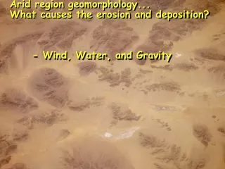
Arid region geomorphology... What causes the erosion and deposition? - Wind, Water, and Gravity . Badlands topography with terraces. Types of streams in Arid and semi-Arid locales Exotic streams - begin in areas that are not arid and flow into the desert.

E N D
Arid region geomorphology... What causes the erosion and deposition? - Wind, Water, and Gravity
Types of streams in Arid and semi-Arid locales Exotic streams- begin in areas that are not arid and flow into the desert. Ex. Nile River, Colorado River, Okavango River Local streams (Arroyos) - begin in the arid region, and often end there as well. There are many streams of this type…
A dry stream channel (arroyo) Note the scale of the boulders
Nile River- An exotic stream
Playa lake, Owens Valley, CA
Linear Dunes With an exotic stream wind
Barchanoid dunes with smaller transverse & barchanoid dunes superimposed on them
Barchan dunes Wind direction Slip face
Barchan dunes Wind direction
Erosional landforms vs. Depositional landforms Erosional forms include... Pediment - bedrock ramp that leads up to the mountain front Plateau- large flat undeformed area that is topographically higher than the surrounding region Mesa- Smaller than the plateau, but basically the same feature Buttes- smaller than the Mesa, but basically the same feature Spires (a.k.a. Hoodoos)- smaller than the buttes
Piedmont in Colorado Piedmont is a geographic designation relating to the slope and or foothills leading to a mountain range
Boulders (foreground) collected from desert pavement (background)