Download
1 / 19
190 likes | 394 Vues
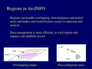
Regions in ArcINFO. Regions can handle overlapping, noncontiguous and nested areas and makes real-world features easier to represent and analyze. Data management is more efficient, as each region only requires one attribute record.

E N D
Regions in ArcINFO Regions can handle overlapping, noncontiguous and nested areas and makes real-world features easier to represent and analyze. Data management is more efficient, as each region only requires one attribute record. Overlapping ranges Non-contiguous areas
Regions in ArcINFO Overlapping polygons - ranges for multiple wildlife species - fires (burned areas) through time, fire atlas data - countries of the world through time - managing habitats, that are not spatially exclusive - managing different floor plans for a building Non-planar features - data in different ‘planes’, for example, soil data collected at various soils depths - geological data that overlaps at various depth levels Noncontiguous areas - islands that comprise the state of Hawaii as a single feature
Regions may have multiple sub-classes - A regions coverage may contain one or more region subclasses - A subclass contains one or more region features - Each region subclass can be visualized as lying in its own ‘plane’ above the polygon topology. - Each region subclass has its own set of attributes because each subclass has its own PAT.
POLYGONS - cannot overlap - single contiguous area - feature class partitions space - cannot be nested - one feature class per cover REGIONS - can overlap - multiple noncontiguous areas - void areas allowed - can have nested features - many feature classes per cover
Creating Regions ? - Regions can be created from coordinate files or digitizing. - Regions can be created and edited interactively using ARCEDIT. - Regions can be generated directly from existing coverages using points or nodes, arcs, polygons or existing regions. - Regions can be created from queries and logical operations on polygon or region coverages
… in ArcINFO REGIONPOLY– converting regions to polygon coverages POLYREGION– creating regions from polygons
………. a few region commands regionpolylistcreates an INFO file that lists the polygons that belong to each region in the specified subclasses regionpolycountcounts the total number of regions, and regions by subclass, for each polygon. The selected polygon belongs to two regions, one from each subclass regionxareacreates an output INFO file to describe the overlap relationship between the two regions in area and percent regionselectselects a set for polygons or regions through Boolean selection of attribute values of polygons or regions from multiple subclasses regionquerycreates new regions based on the attribute values of input region or polygon layers and aggregates regions according to specified attribute items.
Example of fire-atlas data from the Selway – Bitterroot Wilderness
Potential Vegetation Types • Western redcedar • Douglas-fir • Grand Fir • Lower Subalpine Dry • Lower Subalpine Moist • Upper Subalpine Dry • Upper Subalpine Moist • Rock/Alpine/Barren Land
Fire Eras Pre-Modern Suppression Prior to 1935 Modern Suppression 1935 - 1974 Wildland Fire Use 1975 - 1996
Changes within the fire eras • Fire frequency • Severity
Fire frequency NaExtremely infrequentVery infrequentInfrequentFrequentVery frequent Current Fire Regimes 1995, ICRB Historic Fire Regimes 1900, ICRB • Fire Regime • “The nature of fires occurring over an extended period of time” • -(Brown, 1995)
Fire regimes have been described with the help of Digital Fire Atlases and Aerial Photo Interpretation
Results – Fire Severity ….by Casey Teske Stand Replacing Non-Lethal MixedUnknown Area (Ha)
……examples of how to use regions Create a map showing how many times each polygon in the Selway-Bitterroot regions coverage has burned between 1880 and 1996. Hint: use the REGIONPOLYCOUNT command What is the average area burned per year within the three ‘fire eras’: - Pre-modern suppression 1880 - 1934 - Modern suppression 1935 - 1974 - Wildland fire use 1975 - 1996
ArcINFO HELP! help Arc Documentation