Download
1 / 24
410 likes | 1.74k Vues
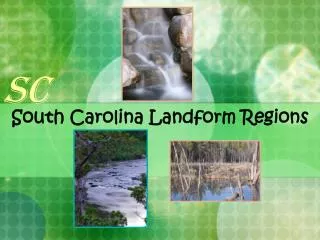
LANDFORM REGIONS IN CANADA. Classroom Notes and Review. 1. What is a region?. An area that has similar characteristics. . 2. Canadian Landforms. Landform Region: - An area of land whose surface is shaped differently from another area of land. Three types of landforms:

E N D
LANDFORM REGIONS IN CANADA • Classroom Notes and Review 1
What is a region? • An area that has similar characteristics. 2
Canadian Landforms • Landform Region: • - An area of land whose surface is shaped differently from another area of land. • Three types of landforms: • - shield, highlands, and lowlands 3
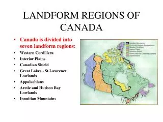
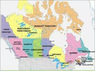
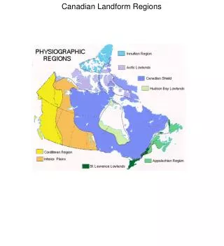
LANDFORM REGION MAP OF CANADA • Canada is divided into seven landform regions: • Canadian Shield • Interior Plains • Great Lakes – St. Lawrence Lowlands • Arctic and Hudson Bay Lowlands • Appalachian Mountains • Innuitian Mountains • Western Cordillera 4
CANADIAN SHIELD • The area has been subjected to a number of major glaciations. • The scraping and gouging action of the ice has left depressions in the bedrock which have filled with water to form hundreds of thousands of lakes. • The bedrock is impervious – water does not pass through it. • The sand and gravels deposited by the glaciers (from the scraping and gouging) have forced the rivers to flow in many different directions – resulting in a very disorganized pattern of winding rivers, lakes and swamps. • The Canadian Shield is the geographic foundation of Canada. • More than half of Canada is covered by the Shield. • Covers 4,800, 000 km2 • Igneous and metamorphic rock make up the Shield – it contains some of the oldest rocks in the world. • Once a major mountain region, the Canadian Shield is now relatively flat with rounded rocky hills. 5 The Canadian Shield
CANADIAN SHIELD Gouges and Scrapes Hundreds of Lakes Poor Drainage Patterns Rocky Outcrops 6
Economic Activity In Shield • Forestry • Valuable minerals which are mined • Include zinc, gold, lead, nickel, copper • Uranium and Diamonds • Known as Canada’s storehouse for metallic minerals 7
INTERIOR PLAINS • The Interior Plains make up the southern parts of Manitoba and Saskatchewan, almost all of Alberta and the western part of the Northwest Territories. • The Interior Plains are made up of sedimentary rock • Used to be a shallow land sea approximately 500 million years ago • Sediments in lake settled • This rock contains much of Canada’s oil and gas reserves. • Potash is also a mineral found in the Interior Plains • Covered by an ice sheet approximately 12,000 years ago • Once sheet melted, left a huge lake called Lake Agassiz-the largest lake in North America at that time. It covered Most of Manitoba, leaving very fertile soil after it disappeared • Differential erosion has caused the formation of several escarpments resulting in four different levels of elevation. • Each level contains low mountains, forests and river valleys • Three of these regions are located in the southern part of the Interior Plains and the other in the north 8
INTERIOR PLAINS On the western part of the Interior Plains is the Alberta Plains – including the foothills of the Rockies. Foothills of Alberta The Saskatchewan Plain is very flat and lower in elevation than the Alberta Plain. It is here that we find much of the best farmland in Canada and almost all of our wheat fields. Saskatchewan Wheat Fields The eastern part of the Interior Plains is called the Manitoba Lowlands and is separated from the Saskatchewan Plains by the Manitoba Escarpment. The Manitoba Lowlands are very flat and are located in the Southern part of Manitoba – including the several large lakes found there. The Manitoba Lowlands The final area of the Interior plains is called the Mackenzie Lowlands and stretches north from Alberta along the Mackenzie Valley to the Arctic Ocean. While the rest of the Interior Plains slope eastward the Mackenzie Lowlands slope toward the north. Mackenzie Lowlands 9
GREAT LAKES – ST. LAWRENCE LOWLANDS • The Great Lakes – St . Lawrence Lowlands consists of two regions. • The Great Lakes Lowlands are located in Southern Ontario. • Formed from sedimentary rock • There are several escarpments in the area – the most famous is the Niagara Escarpment which extends from Niagara Falls to Manitoulin Island. • Great Lakes are only 20000 years old • Giant puddles left from melt water during the end of the last ice age • The Great Lakes portion of the lowlands was subjected to many glaciations in the past – creating a rolling landscape. • Several major glacial features are evident in the landscape – including eskers, drumlins and moraine. • A significant moraine – the Oak Ridges Moraine runs for about 160 km – parallel to Lake Ontario . Oak Ridges Moraine Niagara Escarpment 10
GREAT LAKES – ST. LAWRENCE LOWLANDS • The St. Lawrence Lowlands is separated from the Great Lakes Lowlands by a thin wedge of the Canadian Shield • This cuts across the St. Lawrence and extends into the United States just east of Kingston. • This area is called the Frontenac Axis. • The Thousand Islands in the St Lawrence River are the remains of the shield after being subjected to the erosive force of the St. Lawrence River. • The St. Lawrence Lowland was formed by a faulting action – forming a rift valley. • A rift valley occurs when two or more tectonic plates move apart from one another. • This rift valley was covered with water, then drained, this gives it a smooth look today. • The St Lawrence River flows through this valley on its way to the Atlantic Ocean. Thousand Islands 11
GREAT LAKES-ST.LAWRENCE LOWLANDS • Economic and cultural heartland of Canada • Most densely populated region in Canada • Most fertile soil and longest growing season-Niagara Peninsula • Some fossil fuels around Sarnia 12
ARCTIC AND HUDSON BAY LOWLANDS • The Arctic Lowlands are made up of a series of Islands located in Canada’s far north • The region is marked by a gently rolling landscape • Ice covered, ground is frozen most of the year • Sedimentary rock, containing lignite (a form of coal) • Oil and natural gas deposits are located here as well. Arctic Lowlands Muskeg 13
Around the southwestern shore of Hudson and James Bay is a very flat, low area covered by swampy forest called the Hudson Bay Lowlands. • This area has layer of sedimentary rock resting on top of the ancient rocks of the Canadian Shield. • In this region the swampy areas are called muskeg – the water here is often stagnant. • This region was covered by water during the last glaciation. • The vegetation is mostly bushes and isolated trees. • Isostatic Rebound-ice lifted and the ground raises • Youngest physiographic region in Canada 14
APPALACHIAN MOUNTAINS • The Appalachian Mountains runs through the Gaspe Peninsula of Quebec, into New Brunswick, Nova Scotia and into Newfoundland. • These mountains are made of mainly sedimentary rock • They are the oldest highland region in Canada (formed 300 million years ago) – formed by the converging plates of Pangaea • This area is rich with non-metallic minerals (ie. Coal). • Hydro electricity, fishing, and mining are major industries in this region. • Millions of years of erosion have reduced the once jagged peaks to rolling mountains and hills. • More recent glaciations have added to the leveling of these mountains, Low Mountains Wide Eroded Valleys 15
INNUITIAN MOUNTAINS • The Innuitian Mountains form the northern edge of the country in Nunavut. • Formed in the Mesozoic Era • Some igneous and metamorphic rocks but mostly sedimentary rock. • Created by the northward movement of the North American Plate during the Mesozoic era. • Very few people live this far north. • The mountains are tall and jagged • Glaciers exist throughout these mountains. • They are taller than the Appalachians but lower than the Western Mountains • In some places reach 2500m in height • The area is resource rich, much like the Appalachians, but due to the harsh climate, tapping these resources seems virtually impossible. Innuitian Mountains Ellesmere Island 16
WESTERN CORDILLERA • The term ‘cordillera’ means mountain or mountainous. • In Canada, the Western Cordillera region covers most of British Columbia and the Yukon Territory.’ • Contains igneous, metamorphic and sedimentary rock. • The great height and rugged appearance of the mountains tell us they are very young. • The collision of the North American and the Pacific plates uplifted the region into several mountain ranges. 17
WESTERN CORDILLERA • The mountains and valleys of the Western Cordillera run in a north-south direction. • The “Rocky Mountains” are the most commonly known mountain range – but, the Rockies are just a small part of the Western Cordillera. • There are three major divisions of the Western Cordillera. • - Eastern Mountains • - Interior Plateaus • - Coast Mountains The Rocky Mountains 18
Eastern Mountains • Comprised of the Rocky Mountains, the Rocky Mountain Trench and the Columbia Mountains. • Sedimentary rock, with pockets of metamorphic rocks (metallic minerals) • Rocky Mountain Trench: • Massive valley, 1400 km in length • Formed by faulting and erosion from rivers and glaciers during the Cenozoic period. • Features include: • Transportation corridor • Tourist and recreational area • Employment opportunities (mining and forestry) • Columbia Mountains; • Easier to mine • 1000 meters shorter in height than the Rockies • Much less jagged as well. 19
Interior Plateaus • The central part of the Western Cordillera is called the Interior Plateau. • It is a highland region with rugged plateaus divided by deep river valleys. • 1300 to 2000 meters in height • Metamorphic and igneous rock • One of the major rivers running through this area is the Fraser River. Hell’s Gate on the Fraser River 20
Coast Mountains • The western part of the Western Cordillera is called the Coast Mountains region. • Igneous and metamorphic rock and are the direct result of plate tectonics. • This is a very active seismic area and contains the highest peaks in Canada. • The highest peak is located in the northern part of the Coast Mountains near the border with Alaska. It is called Mount Logan. • Two ranges: The Coast Mountain Range and the Island Mountain Range • The ranges are separated by the Pacific Ocean (ie. Vancouver and B.C. Mainland) • People usually settle in valleys on shorelines. Mount Logan 21
Highland Economic Activity • Eastern Mountains-Mining and tourism-skiing and outdoor sports • Interior Plateau-wine country, agriculture, mining • Coastal Mountains-mining and forestry 22