Canada’s Landform Regions
80 likes | 286 Vues
Canada’s Landform Regions. The Canadian Shield. Size: covers almost ½ of Canada Formation: -Formed by volcanic eruptions over 3 billion years ago - erosion and glaciers caused mountains to flatten and lose most of its soil. Landscape:

Canada’s Landform Regions
E N D
Presentation Transcript
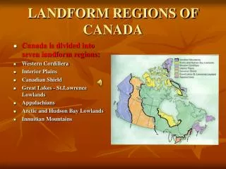
The Canadian Shield Size: covers almost ½ of Canada Formation: -Formed by volcanic eruptions over 3 billion years ago - erosion and glaciers caused mountains to flatten and lose most of its soil Landscape: • Large, smooth rock formations, thousands of lakes and swamps Main Type of Rock: Igneous
The Great Lakes- St. Lawrence Lowlands Size: small Formation: • Sediments from the eroded Canadian Shield built up in ancient seas and formed new land Landscape - Low, fairly flat with some hills - Covered with a rich layer of soil Rock type: majority is Sedimentary
The Appalachians Size: majority of Eastern Canada Formation • Plate movement caused Sedimentary Rock on ocean floor to fold upwards to form mountains • Erosion lowered mountains and flattened some areas Landscape - Mountainous in some areas with some flatter plains (rock) Rock Type: mostly Sedimentary
Interior Plains Size: Covers large area in the interior of Canada Formation -sediments settled at the bottom of inland seas • When sea disappeared, it left a very flat area with thick, nutrient rich soil Landscape - Very flat plains Type of Rock: Sedimentary
Western Cordillera Landscape: • Sets of tall mountains with a flat plateaus in between Rock Type: all 3 types- igneous, sedimentary, metamorphic Size: entire West Coast Formation: 3 areas • Rocky Mountains- plate movements folded the earth • Coast Mountains- Volcanic eruptions • Interior Plateau- formed from lava that flowed from the volcanoes
Hudson Bay and Arctic Lowlands Size- large section of Northern Canada (territories) Formation: • Sedimentary rock left from erosion and glacier scraping Landscape: - Bare rock with stony areas Type of Rock: Sedimentary
Innuitions Size: Northern Canada, most of Nunavut’s northern islands Formation: • Folded sedimentary rock from the ocean floor Landscape -ice and snow covered mountains Rock Type: Sedimentary