Download

1 / 58
630 likes | 1.57k Vues
Landform Regions of Canada. Canadian Geography 11 PowerPoint Presentation . Canada is a land of great physical diversity. Perhaps this is not surprising since Canada is the world’s second largest country, and has the world’s longest coastline.

E N D
Landform Regions of Canada Canadian Geography 11 PowerPoint Presentation
Canada is a land of great physical diversity. Perhaps this is not surprising since Canada is the world’s second largest country, and has the world’s longest coastline. • We can look at Canada’s topography by focusing on landforms. • Topography is the study of the earth’s surface features, including vegetation, soils, and those features shaped by people.
The Canadian Shield has two major landforms, a rocky surface of mainly igneous rock and many coniferous forests. • The reason that this region has rocky surfaces is because millions of years ago there were mountains in the sub-region, through water, freeze thaw and the mountains have eroded into hard even land. • The southern section of the Canadian Shield is mainly boreal, meaning that it is mostly coniferous forests - concentrations of evergreen trees normally found on slopes and mountains. In the northern part it is had rocky frozen tundra.
Vegetation in the Canadian Shield is mainly coniferous forests. In the south the trees are larger and closer together. As you go north, trees are smaller and not as dense. There is eventually a spot up north in the Shield that doesn’t have any forest; this is again in the tundra. Shown above is a coniferous forest located in the middle of the Canadian Shield.
The Canadian Shield is the geographic foundation of Canada. The Shield underlies not only much of Canada but also parts of the United States. The Shield covers more than half of Canada, about 4,800,000 km². • Some of the world’s oldest rocks (3.96 billion years old) are located in the Shield near Great Slave Lake. Today, most of the Shield is relatively flat with rounded hills of rock that are actually the roots of ancient mountains.
Two types of rock, igneous and metamorphic, form most of the Shield. They contain valuable minerals in great quantities. • Through the vast deposits of lead, gold, nickel, copper, zinc, and other important metals, the Canadian Shield is often called the storehouse of Canada’s metallic minerals. In addition, diamonds have recently been found where ancient volcanoes once existed.
How were mineral deposits formed in the rock of the Shield? Minerals were present in magma (molten rock) beneath the earth’s crust. • As magma rose toward the surface, it forced its way into cracks and cavities in the shield rock. This process of magma slowly rising toward the surface took thousands or millions of years. As it cooled, some minerals were deposited in the magma itself.
Other deposits were formed when minerals, dissolved in very hot water, were forced deep into cracks in the surrounding rock. This process allowed minerals to be deposited in high concentrations which makes mining worthwhile. • As the minerals slowly cooled, they separated into layers according to their density. The lighter ones floated on top of the heavier ones. Those that had similar density floated to the same level. Nickel and copper are often found together because they have similar densities.
Mining companies are attracted to the Shield because of the presence of metallic minerals. • Many cities and towns, such as Sudbury in Ontario, Thompson in Manitoba, and Yellowknife in the Northwest Territories, rely on the mining industry for jobs. • The mineral ores are smelted to remove waste materials. The concentrated minerals are shipped to factories in Canada and other parts of the world where they are used to manufacture products we use every day.
While the Shield is well-suited to mining, it is ill-suited to farming because it has very thin soils. However, it is ideal for recreation because of it scenic rivers, waterfalls, lakes, rock outcrops, and vast forests. • Glaciers removed enormous amounts of soil, clay, rock, and gravel from the Shield. Today, a thin layer of soil covers most of the Shield, and the bedrock is visible in many places.
The action of the glaciers affected the drainage (process whereby water is removed from an area by flowing out of depressions in the land such as lakes and rivers.) of the Shield. • The scraping and gouging action of the ice created depressions in the bedrock (solid rock beneath the soil). These depressions filled with water to form the hundreds of thousands of lakes that now 0dot the Shield. • Because the bedrock is impervious (quality of a substance that does not allow water to pass through it), water does not pass through it.
The glaciers deposited sand, gravel, and clay that dammed rivers or forced them to flow in different directions. • The result is a very disorganized pattern of winding rivers, lakes, and swamps. • These rivers and swamps are the breeding ground for the many blackflies and mosquitoes found on the Shield. People visit the Shield to canoe, fish, hunt, and get back to nature.” The tourist industry is very important to the towns and cities in the southern part of the Shield.
The Shield’s plentiful water flows have made it an excellent source of water-generated energy, and the pattern of drainage has affected where hydro-electrical plants are located. The centre of the Shield is much lower than its outer portion. • This gives it the appearance of a saucer, with Hudson Bay occupying the low-lying centre. As a result, most of the rivers of the Shield flow toward its centre and into Hudson Bay.
Hydroelectric generating stations have been built where the rivers tumble from the Shield onto the Hudson Bay Lowlands. The energy produced by these stations is transmitted by power lines to cities and towns both on and off the Shield.
Above: The frozen tundra of the Northern area of the Canadian Shield
The Interior Plains of Canada are part of the Great Plains of North America that stretch from the Arctic Ocean to the Gulf of Mexico. • The Interior Plains of Canada extend from the 49th parallel north to the Arctic Ocean, a distance of 2700 km. They are about 1300 km wide in the south but only about 275 km wide in the north.
Shallow inland seas often covered the Interior Plains. Sediments from the Shield and the Rocky Mountains were deposited in these seas over millions of years. • Eventually the sediments were compressed by the weight of the layers above into sedimentary rock. • Part of the sedimentary rock deposited in these areas consists of coral reefs that formed close to the surface of seas during the Paleozoic era.
Remember that Canada was closer to the equator at this time. Over millions of years, plate movements have placed Canada in its current location. • The rock layers are several thousand metres thick and took millions of years to form. • Today, the reefs are thousands of metres below the surface of the land. They contain much of the oil and gas found in Alberta and Saskatchewan.
Mineral deposits also lie below the surface. At various times during the Mesozoic era, shallow seas covered the region that is now Saskatchewan. • When they evaporated, thick layers of mineral deposits were left in the dried-out sea beds. These layers are now deep in the earth, covered by newer rocks and glacial deposits.
Potash is mined from these layers and used as fertilizer in Canada and overseas. The swamps on the edges of these ancient seas produced plants that were changed eventually into coal which is mined today. • Forces of erosion have also shaped the surface of the landscape. Some sedimentary rocks are hard and resistant; others are quite soft. The softer rock erodes more quickly than the harder rock – a process called erosion.
Although many people think of the Interior Plains as flat, there are relatively few areas where this is true. • The landscape is, for the most part, composed of rolling hills, and deep, wide, river valleys. Overall, the land slopes gently downward from west to east. • Glaciation has also marked the landscape in visible ways and affected land use. The Interior Plains, like the rest of Canada, were subjected to glaciation. The glaciers left deposits that produced a rounded, gently rolling landscape in many areas.
When the glaciers melted, the meltwater formed a large lake over much of what is now southern Manitoba and Saskatchewan Later, the land rose, causing most of the water to drain into the ocean. • Small portion of the ancient lake remain today as Lake Winnipeg, Lake Manitoba, Lake Winnipegosis and Cedar Lake. The floor of this lake was covered by sediments that made it very flat. The former lake bottom was left as flat land in what is now southern Manitoba and Saskatchewan.
The soil that developed on these sediments is deep and fertile. Grain is grown in many locations in the southern part of the Interior Plains. • The area is known as Canada’s “breadbasket” because so much wheat is grown here. Cattle are raised in places where the climate is too dry for crops. Agricultural products from this region are used both in Canada and overseas.
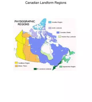
The Lowlands There are three lowland regions surrounding the Shield: the Great Lakes-St. Lawrence Lowlands, the Hudson Bay and Arctic Lowlands. The bedrock under these lowlands is formed mainly of sediments eroded from the Shield. The sediments were laid down in the seas that existed at various times millions of years ago. As the rock particles collected, the weight of the upper layers compressed the lower layers into sedimentary rocks.
South of the Canadian Shield is a smaller landform region, the Great Lakes-St. Lawrence Lowlands. • As you might suspect from the name, the regions consists of two parts. The parts are separated by a thin wedge of the Canadian Shield that juts across the St. Lawrence River and extends into the United States near Kingston, Ontario. • Like the Interior Plains, these lowlands have bedrock formed of sedimentary rock from the Paleozoic era.
In the Great Lakes portion of the lowlands, glaciation has created a rolling landscape. • The glaciers carried huge amounts of material (soil, sand, and gravel) from the Canadian Shield and dumped them throughout the region). • Flat plains with glacial hills and deep river valleys characterize the landscape.
The Great Lakes are located in basins that were gouged out by glaciers. • The lakes were even larger than they are today because of the enormous volume of water from the melting glaciers. • They eventually shrank to their present size as the meltwater drained into the ocean. The old shorelines of these glacial lakes surround the present-day Great Lakes.
The St. Lawrence Lowland was formed in a different way from the Great Lakes Lowland. A rift valley was formed by faulting. This rift valley was flooded toward the end of the last ice age by part of the Atlantic Ocean.
The Great Lakes-St. Lawrence Lowlands Region is the most southerly region in Canada. It is well-suited to agriculture because if its excellent soils and warm climate. • The flat land is also ideal for transportation routes and the development of cities. Because of these factors, it is the most densely populated region in Canada.
About 50% of Canada’s population lives in the Great Lakes-St. Lawrence Lowlands which compromise only 14% of Canada’s area. • Canada’s two largest cities, Toronto and Montreal, are located here along with 70% of the country’s manufacturing industries.
The Hudson Bay Lowlands are the 3rd largest wetland in the world. • Remember that a wetland is an area where water is the controlling environmental factor. It occurs where the water table is at or near the land surface, or where shallow water covers the land.
This area is composed mostly of muskeg or peat lands (grouped by biologists into bogs and fens), and dotted with ponds, lakes and streams. • The drier areas are broken up by stands of balsam poplar, aspen, white spruce and balsam fir and in the muskeg by black spruce and tamarack.
Around the southwestern shore of Hudson Bay and James Bay is a very flat, low area covered by swampy forest. • The waters of Hudson Bay covered much of this lowland at the end of the last Ice Age. Known as the Hudson Bay Lowlands, this region has a layer of sedimentary rock that rests on top of the ancient rock of the Shield.
The Arctic Lowlands are made up of a series of islands locate din Canada’s far north, and have a gently rolling landscape. • The harsh climate does not permit farming; the ground remains frozen most of the year. • However, the Paleozoic sedimentary rock, from which the Lowlands are formed, contains lignite (a form of coal), oil, and natural gas deposits.
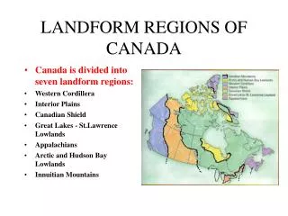
Mountain Rim (The Highlands of Canada) Canada’s three highland areas lie to the east, north, and west of the Shield and lowland areas. Each of these three striking, mountainous areas – the Appalachians, the Innuitians, and the Western Cordillera – has a different geological history and appearance.
The Western Cordillera stands along the western edge of Canada like a great wall: range after range of mountains by plateaus and valleys. • The great height and rugged appearance of these ranges tell us that they are geologically young.
The collision of the North American and the Pacific plates is responsible for uplifting this region into several mountain ranges about 68- km wide. • The heavier Pacific plate forced its way under the lighter North American plate causing much folding, faulting, and volcanic activity. The result was the Western Cordillera.
The mountains and valleys of the Western Cordillera run in a north-south direction. This presents an obstacle to transportation because main travel routes across the Cordillera must run in an east-west direction. • There are only a few passes, or gaps, in the ranges of the Cordillera that are low enough to allow highways and railways to cross over.
Since it is so mountainous, the Cordillera is lightly populated. Most people live in the farming and mining towns located in the river valleys. • Vancouver and Victoria, the largest cities in the Western Cordillera, are built on flat land in coastal locations.
The glaciers in the mountains of the Western Cordillera are the only remaining glaciers in Canada apart from those in the Arctic. These glaciers add to the beauty for which the Canadian West is famous. • There are “3” major divisions in the Western Cordillera. The Rocky Mountains and the Columbia Mountains, among others, make up the eastern mountains. The Interior Plateaus to the west of these ranges make up the second division. The Coast Mountains on the western edge of the Cordillera make up the third.