
2004 BAR-GC Projects
E N D
Presentation Transcript
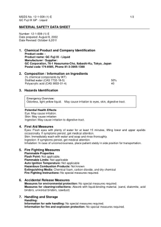
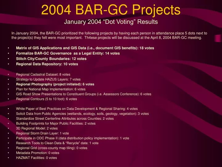
2004 BAR-GC Projects January 2004 “Dot Voting” Results In January 2004, the BAR-GC prioritized the following projects by having each person in attendance place 5 dots next to the project(s) they felt were most important. Th4ese projects will be discussed at the April 8, 2004 BAR-GC meeting. • Matrix of GIS Applications and GIS Data (i.e., document GIS benefits): 18 votes • Formalize BAR-GC Governance as a Legal Entity: 14 votes • Stitch City/County Boundaries: 12 votes • Regional Data Repository: 10 votes • Regional Cadastral Dataset: 8 votes • Strategy to Update HAZUS Layers: 7 votes • Regional Photography (project initiated): 6 votes • Plan for National Map Implementation: 6 votes • GIS Road Show Presentations to Constituent Groups (i.e. Assessors Conference): 6 votes • Regional Contours (5 to 10 foot): 6 votes • White Paper of Best Practices on Data Development & Regional Sharing: 4 votes • Solicit Data from Public Agencies (wetlands, ecology, soils, geology, vegetation): 3 votes • Standardize Street Centerline Attributes across Counties: 2 votes • Building Footprints for Major Public Facilities: 2 votes • 3D Regional Model: 2 votes • Regional Storm Drain Layer: 1 vote • Participate in ODC Phase II (data distribution policy implementation): 1 vote • Research Tools to Clean Data & “Recycle” data: 1 vote • Regional Grid (cross-county map tiling): 0 votes • Metadata Promotion: 0 votes • HAZMAT Facilities: 0 votes