Enhancing GIS Data Interoperability with FME Solutions
Learn how Johnson County AIMS integrates Safe Software's FME for GIS data manipulation, allowing for seamless import/export processes and enhanced data distribution in various formats.

Enhancing GIS Data Interoperability with FME Solutions
E N D
Presentation Transcript
Abstract Johnson County AIMS serves as a GIS data service provider for 21 cities and 510,000 residents. In addition to providing data, AIMS also receives GIS data from both the private and public sector. AIMS must be able to import and export GIS data to multiple GIS and CAD formats. In looking at various solutions, including ESRI's data interoperability extension, AIMS has incorporated Safe software's FME (feature manipulation extraction) into their everyday business processes. FME is used in generalizing Johnson County's utility data from multiple service providers and allows for easy re-distribution of this data in different formats. This paper will look at why AIMS decided to use FME and how FME is been used on an every day basis within a County government GIS organization.
What was the problem? • DDR (Digital Data Request) • Have to replace an AML based distribution process • Have to output DXF, DGN, shape, and e00 • Want to output DWG • Here is an example
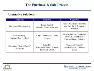
Choices • Write everything in ArcObjects • Possible but would be a lot of work • Requires advanced skills • Data Interoperability Extension • Still a couple of months away at the time • Only works through ArcMap and we need to automate things • FME • Did everything we wanted • A bit Expensive • Somewhat complex, but simple to use • Easy to automate
29 Input feature classes • 1 Input clip rectangle • 69 Output DWG layers • 32 Transformers
What else do we use it for now? • CUE (Collaborative Utility Exchange) • Collect and process data from many different sources
Data from 8 different sources • Input formats • Shapefile • Personal Geodatabase • Enterprise Geodatabase
I/CAD Support • Push our data into DGN format to support our law enforcement dispatch system
Daily Uses • Adding lat/long to our address file • Producing intersections from our centerline file • Producing a feature class from septic permit data • Producing a line file from annotation for use in our IMS • Producing a point dataset out of our property feature class • Import AutoCAD based utility information into geodatabase
Conclusions • 4000+ (mostly successful) DDR requests run without supervision • 85 separate FME files run on a regular basis • 10 FME files run on a nightly basis • A multitude of nasty problems fixed with drag and drop processes • Cost has been offset by benefits
Keith Shaw Lead Developer 913-715-1567 Keith.Shaw@jocogov.org