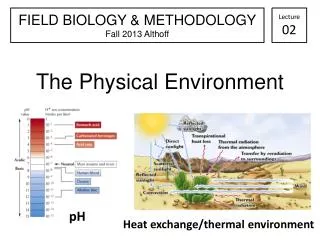
Characterizing the Physical Environment
This text delves into the significance of understanding local site properties in the context of environmental management. It emphasizes the role of microclimate, including local climatic variations influenced by topography and vegetation, and examines how these factors can affect soil properties and management activities. Through analyzing microclimate elements like temperature, precipitation, and wind patterns, along with detailed soil profiles, this guide provides essential insights into the characteristics that may constrain management practices and highlight sensitive areas impacted by changes.

Characterizing the Physical Environment
E N D
Presentation Transcript
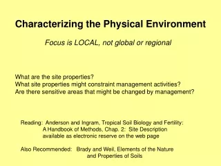
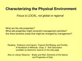
Characterizing the Physical Environment Focus is LOCAL, not global or regional What are the site properties? What site properties might constraint management activities? Are there sensitive areas that might be changed by management? Reading: Anderson and Ingram, Tropical Soil Biology and Fertility: A Handbook of Methods, Chap. 2: Site Description available as electronic reserve on the web page Also on Library Reserve: Brady and Weil, Elements of the Nature and Properties of Soils
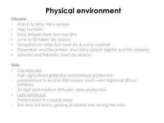
We’ll focus on 2 aspects of the Physical Environment: Microclimate Soils
Microclimate Local climatic conditions that differ from the regional climate Caused by topography, vegetation, humans… E.g. Air temperature Soil temperature Precipitation: Quantity of Rainfall, Snowfall Chemistry of each Wind Solar radiation
A few basic atmospheric principles: Hot air rises: less dense Cold air sinks: more dense Air moves from hot areas cold areas (high pressure) (low pressure) Hot air holds more water Changing vegetation can affect: soil and air temperatures, wind patterns, humidity, light etc….. which can affect revegetation, restoration...
Solar radiation: shortwave radiation Earth radiation: longwave radiation Brady and Weil 2002
Changes in air temperature from forested to open areas with little topographic effect Forman 1995
A frost pocket can form when cold air (heavier) flows down slopes and forces warmer air to rise. • Obstructions on slope can also form localized cold pockets Harris et al 2004
Example of Topographic effects on winds Forman 1995
Urban climate Heat Island Miller 2004 Example of an idealized urban heat island showing late afternoon temperature changes with density of development.
A large body of water can moderate air temperature, particularly on the leeward side (downwind) of the water Harris et al 2004
Max Current Min Microclimate measurements Temperature Wind speed Rainfall (quantity and quality) Throughfall (quantity and quality) Max/Min Thermometer Wind speed gauge
Microclimate can affect: vegetation wildlife soils water …. By changing temperature, water, wind….
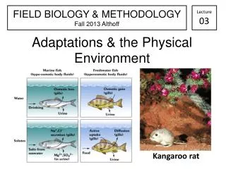
Soils Know what’s there: soil types landscape patterns major physical properties chemistry? biota? Past land-use effects Indianola soil
An example of a cross section of a soil showing a soilprofile that includes possible soil horizons. Actual soil profiles will vary in the number and type of horizons that are present, and in the sequence of horizons. 14
ALDERWOOD SERIES The Alderwood series consists of moderately deep to a cemented pan, moderately well drained soils formed in glacial till. Alderwood soils are on glacially modified foothills and valleys and have slopes of 0 to 65 percent. The average annual precipitation is about 40 inches, and the mean annual temperature is about 50 degrees F. TYPICAL PEDON: Ap--0 to 7 inches; very dark grayish brown; gravelly ashy sandy loam; moderate fine granular structure; slightly acid (pH 6.2). (3 to 7 inches thick) Bs1--7 to 21 inches; dark yellowish brown; very gravelly ashy sandy loam; weak medium subangular blocky structure; slightly acid (pH 6.2). Bs2--21 to 30 inches; dark brown; very gravelly ashy sandy loam; weak medium subangular blocky structure; slightly acid (pH 6.2). (Combined Bs1 and Bs2 horizons are 15 to 30 inches thick) 2Bs3--30 to 35 inches; 50% olive/yellowish brown and 50% dark greyish brown; very gravelly sandy loam, some cemented fragments, massive; moderately acid (pH 6.0). (0 to 15 inches thick) 2Bsm--35 to 43 inches; dark grayish brown cemented layer that crushes to very gravelly sandy loam; massive; 40 percent pebbles; moderately acid (pH 6.0). (5 to 20 inches thick) 2Cd--43 to 60 inches; grayish brown compact glacial till that breaks to very gravelly sandy loam; massive; extremely hard; 40 percent pebbles; moderately acid (pH 6.0).
Soil types and Landscape Patterns A soil association common in the Puget Sound area showing soil type relative to different glacial deposits
(the study of landforms and their relationship to underlying rocks ) Geomorphology Topographic Maps Geologic Maps Schoeneberger et al. 1998
Land and soil stability Examples of types of hillslope failures Soil type is typically related to slope stability Dunne and Leopold, 1998
Collecting Soil Information Soil Surveys Maps Profile descriptions Tables on soil properties: physical, chemical engineering land capabilities plant growth
Soil Measurements in the Field Soil horizons depths and properties Soil temperature Depth to water table
Collect ‘grab’ samples for chemical analysis Known volume sample for bulk density With horizon depth, bulk density and concentration, you can then determine the quantity of an element in an area One way to measure bulk density is using a corer
Sieve samples to 2mm Air dry samples after returning from field for chemical analysis Oven dry for moisture content or bulk density (105oC) 2mm sieve Balance
Some Soil analyses…. Total N using combustion (CHN) Flow analyzer for (NH4, NO3, SO4,…) pH meter
Environmental Characterization • Gather available knowledge of the site • -- Local or regional climate data • -- Collect maps: topographic, geologic, soils • -- Determine possible impacts from available knowledge; get site history • -- Examine site – determine site specific issues and info needed 2. Develop a plan for collecting data -- What is the most important data needed? -- Where will you collect samples from or take measurements? (spatially) -- How often will you collect it? -- How will samples be analyzed? -- Do you have all data needed to utilize a measurement? -- Can you afford this?
Environmental Characterization 3. Understand the limitation of instruments, types of chemical analyses -- e.g., total versus dissolved P • Make sure the data collection will address needs • without artifacts or bias or waste (rethink!) • -- enough samples? replication? random sampling or • blocking for an environmental gradient? • right location? • -- proper chemical analysis? • -- everything you need to make a final calculation and • final report?
Gather available knowledge of the site Develop a plan for collecting data Understand the limitation of data Make sure the data collection will address needs without artifacts or bias or waste