Realm of Kaodith: Procedurally Generated Maps and Terrain Types
Dive into the realm of Kaodith with its one-of-a-kind feature of procedurally generated maps, each session offering a unique experience. Explore hexagon-tiled maps with varied terrain types from mountains to seas. Customize maps using preset terrains and heights. Discover how the map generator utilizes Perlin noise for realistic features like lakes and mountains. Uncover the intricacies of pathfinding with A* search taking cliffs and units into account. Explore, strategize, and conquer in the ever-changing world of Kaodith.

Realm of Kaodith: Procedurally Generated Maps and Terrain Types
E N D
Presentation Transcript
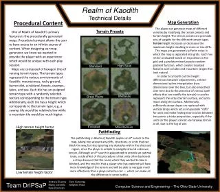
Realm of Kaodith Technical Details Procedural Content One of Realm of Kaodith’s primary features is the procedurally generated maps. Procedural content allows the user to have access to an infinite source of content. When designing our map generator, we knew we wanted to provide the player with an experience which would be unique with each play session. Maps are composed of hexagon tiles of varying terrain types. The terrain types represent the various environments of Kaodith: mountainous, rocky ground, barren dirt, scrubland, forests, swamps, lakes, and sea. Each tile has an assigned terrain type with a randomly selected texture corresponding to the terrain type. Additionally, each tile has a height which corresponds to the terrain type, e.g. a swamp tile would be relatively low while a mountain tile would be much higher. Map Generation The player can generate maps of different varieties by modifying the terrain presets and terrain height. The terrain presets are premade sets of weights for the different terrain types. Terrainheight increases or decreases the maximum height resulting in more or less cliffs. The maps are generated via Perlin noise in which the map is separated into grids. Each hex is then evaluated based on its position in the grid and a predetermined pseudo-random gradient function, which creates localized features such as lakes and mountain ranges that look natural. In order to smooth out the height differences between adjacent tiles, a three-dimensional spline interpolation (two-dimensional over the tiles, but also smoothed over time due to the presence of various spell effects that can modify the terrain) is used to represent the virtual terrain surface, and units move along this surface. Additionally, sufficiently steep slopes are replaced with vertical drops which act as impassable “cliffs” for units and make finding short routes between two points a tricky proposition, especially if the units (or the player) cannot see faraway terrain at all, due to the fog of war. Terrain Presets High Seas Standard Wetlands Great Plains High terrain height factor Forested Mountainous Pathfinding The pathfinding in Realm of Kaodith applies an A* search to the map, taking into account any cliffs, structures, or units that can block the way, but also ignoring any obstacles within the obscured region, since the player is unable to navigate around unknown terrain. Although an A* search is guaranteed to provide an optimal route, a side effect of this procedure is that units often backtrack as they discover that the route which they wanted to take is blocked, and the result is that a player who has explored will have more knowledge of the terrain and will be able to navigate much more effectively than a player who has not — which can make all the difference in some battles. Low terrain height factor Andrew Buelow Mario Carneiro Kyle Donovan Sam Gutentag Stephen Hara Team DriPSaP Computer Science and Engineering – The Ohio State University