Enhancing Desert Watch: Earth Observation for UNCCD in Portuguese Regions
30 likes | 152 Vues
The DesertWatch Extension (DW-E) project utilizes Earth Observation (EO) technology to assist Portuguese, Mozambican, and Brazilian partners in combatting desertification as part of the UNCCD. This initiative aims to create standardized processing methodologies to produce Land Cover maps and Desertification Indicators, facilitating the monitoring of land degradation risks. With a successful adaptation of the original DesertWatch project, DW-E will offer comprehensive data analysis at local, national, and regional scales, enabling informed responses to the desertification crisis globally.

Enhancing Desert Watch: Earth Observation for UNCCD in Portuguese Regions
E N D
Presentation Transcript
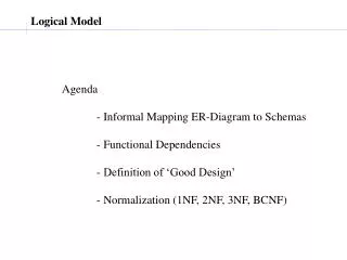
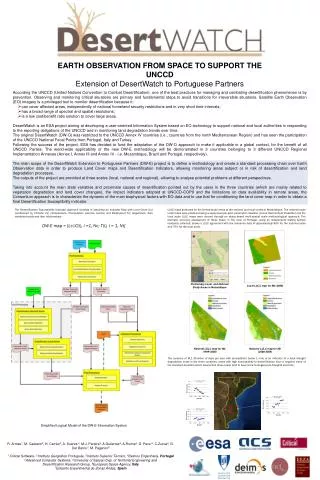
RL1-variance EARTH OBSERVATION FROM SPACE TO SUPPORT THE UNCCD Extension of DesertWatch to Portuguese Partners • According the UNCCD (United Nations Convention to Combat Desertification), one of the best practices for managing and combating desertification phenomenon is by prevention. Observing and monitoring critical situations are primary and fundamental steps to avoid transitions for irreversible situations. Satellite Earth Observation (EO) imagery is a privileged tool to monitor desertification because it: • can cover affected areas, independently of national homeland security restrictions and in very short time intervals; • has a broad range of spectral and spatial resolutions; • is a low cost/benefit ratio solution to cover large areas. • DesertWatch is an ESA project aiming at developing a user-oriented Information System based on EO technology to support national and local authorities in responding to the reporting obligations of the UNCCD and in monitoring land degradation trends over time. • The original DesertWatch (DW-O) was restricted to the UNCCD Annex IV countries (i.e., countries from the north Mediterranean Region) and has seen the participation of the UNCCD National Focal Points from Portugal, Italy and Turkey. • Following the success of the project, ESA has decided to fund the adaptation of the DW-O approach to make it applicable in a global context, for the benefit of all UNCCD Parties. The world-wide applicability of the new DW-E methodology will be demonstrated in 3 countries belonging to 3 different UNCCD Regional Implementation Annexes (Annex I, Annex III and Annex IV - i.e. Mozambique, Brazil and Portugal, respectively). The main scope of the DesertWatch Extension to Portuguese Partners (DW-E) project is to define a methodology and create a standard processing chain over Earth Observation data in order to produce Land Cover maps and Desertification Indicators, allowing monitoring areas subject or in risk of desertification and land degradation processes. The outputs of the project are provided at three scales (local, national and regional), allowing to analyse potential problems at different perspectives. Taking into account the main state variables and proximate causes of desertification pointed out by the users in the three countries (which are mainly related to vegetation degradation and land cover changes), the impact indicators adopted at UNCCD-COP9 and the limitations on data availability in remote areas, the Consortium approach is to characterize the dynamic of the main biophysical factors with EO data and to use that for conditioning the land cover map in order to obtain a final Desertification Susceptibility indicator. The Desertification Susceptibility Indicator approach consists in obtaining an Indicator Map with Land Cover (Lc) conditioned by Climatic C(i) (Temperature, Precipitation extreme events) and Biophysical T(i) (Vegetation, Soil) variables trends and their relationships. DW-E map = [Lc|C(i), i =1, Nc; T(i), i = 1, Nt] LULC maps produced for the limited study areas at the national and local scales in Mozambique. The national scale LULC maps were produced using a supervised per-pixel parametric classifier (Linear Discriminant Classifier) and the local scale LULC maps were derived through an object-based multi-spatial scale methodological approach. The thematic accuracy assessment of these maps, in the case of Portugal, using an independent testing sample randomly collected, shows a LULC agreement with the reference data of approximately 85% for the national scale and 75% for the local scale. Preliminary Local and National Study Areas in Mozambique Local LULC map for Mz (2008) National LULC map for Mz (1999-2000) National LULC map for Mz (2008-2009) The variance of RL1 (Number of days per year with precipitation below 1 mm) is an indicator of a local draught degradation index in the three countries: areas with high susceptibility to desertification have a negative trend of the standard deviation which means that those areas tend to have more homogeneous droughts over time. Simplified Logical Model of the DW-E Information System R. Armas1, M. Caetano2, H. Carrão2, A. Soares 3, M.J. Pereira3, A.Gutierrez4, A.Rocha4, G. Pace 5, C.Zucca6, G. Del Barrio7, M. Paganini8 1 Critical Software, 2 Instituto Geográfico Português, 3Instituto Superior Técnico, 4Deimos Engenharia, Portugal 5Advanced Computer Systems, 6University of Sassari Dep. of Territorial Engineering and Desertification Research Group, 8European Space Agency, Italy 7Estación Experimental de Zonas Áridas, Spain