Optimal Residential Property Selection in Cleveland's Ward 18
Identify top 5 locations for single-family homes based on area, zoning, population patterns, proximity to transit, elevation, and floodplain status using GIS analysis.

Optimal Residential Property Selection in Cleveland's Ward 18
E N D
Presentation Transcript
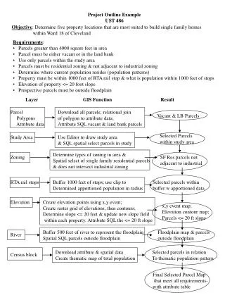
Project Outline Example UST 486 Objective: Determine five property locations that are most suited to build single family homes within Ward 18 of Cleveland • Requirements: • Parcels greater than 4000 square feet in area • Parcel must be either vacant or in the land bank • Use only parcels within the study area • Parcels must be residential zoning & not adjacent to industrial zoning • Determine where current population resides (population patterns) • Property must be within 1000 feet of RTA rail stop & what is population within 1000 feet of stops • Elevation of property <= 20 foot slope • Prospective parcels must be outside floodplain Layer GIS Function Result Parcel Polygons Attribute data Download all parcels; relational join of polygon to attribute data; Attribute SQL vacant & land bank parcels Vacant & LB Parcels Selected Parcels within study area Study Area Use Editor to draw study area & SQL spatial select parcels in study Determine types of zoning in area & Spatial select of single family residential parcels & does not intersect industrial zoning Zoning SF Res parcels not adjacent to industrial RTA rail stops Buffer 1000 feet of stops; use clip to Determined apportioned population in radius Selected parcels within buffer w apportioned data Elevation Create elevation points using x,y event; Create raster grid of elevations, then contours; Determine slope <= 20 feet & update new slope field within each property. Attribute SQL the <= 20 ft slope x,y event map; Elevation contour map; Parcels <= 20 ft slope Buffer 500 feet of river to represent the floodplain Spatial SQL parcels outside floodplain Floodplain map & parcels outside floodplain River Download attribute & spatial data Create thematic map of total population Selected parcels in relation To thematic population pattern Census block Final Selected Parcel Map that meet all requirements- with attribute table