Download
1 / 18
180 likes | 315 Vues
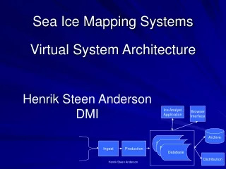
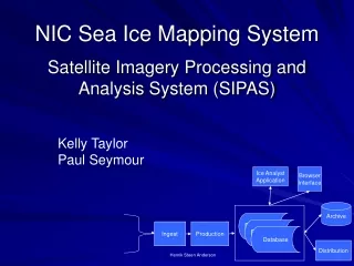
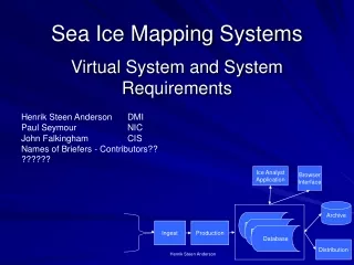
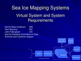
Database. Database. Database. Sea Ice Mapping Systems. Virtual System and System Requirements. Henrik Steen Anderson DMI Paul Seymour NIC John Falkingham CIS and the Standing Committee on Data, Archives and Customer Support. Ice Analyst Application. Browser Interface. Archive.

E N D
Database Database Database Sea Ice Mapping Systems Virtual System and System Requirements Henrik Steen Anderson DMI Paul Seymour NIC John Falkingham CIS and the Standing Committee on Data, Archives and Customer Support Ice Analyst Application Browser Interface Archive Ingest Production Distribution Henrik Steen Anderson
Introduction • Introduction to Ice Mapping Systems • Architecture - 4.3 (1) • Common Requirements - 4.3 (3) • Current Or Planned Systems - 4.3 (2) • Display Environmental Fields - 4.3 (4) • Summary and Working Plan
Motivation • IICWG members can reduce development costs by: • a) sharing information • b) sharing software modules where possible.
Sea Ice Mapping Systems – Speakers • Introduction: Paul • Architecture and requirements: Paul - 4.3 (3) and (1) • Current Systems – Env. Fields: - 4.3 (2+4) • Baltic Robin • DMI Keld • NIC Kelly • CIS John • Summary: John, Paul
Database Database Database Virtual Ice Charting System Browser Interface Ice Analyst Application Chart Production Archive Ingest Imagery Production Distribution
Ingest Data from different sources are ingested and made ready for further production, including formatting. • Isolate unique formats of external data from a common geospatial internal format • Modular to allow new data types to be added • Metadata preserved along with data • Supports multiple projections • Support for multi-spectral imagery
Production Production includes rectification, compositing (spectral, spatial and time), value adding, e.g. production of SST fields and SAR filtering. • Ability to apply custom algorithms • Rectification • Compositing • Value addition • Data extraction (e.g. to GRIB) • Classification routines
Database The database is an online representation of data and products relevant for the ice analyst, e.g. images, old ice charts, wind fields etc. There may be one or several databases. • All data co-registered geospatially • Robust, reliable • Fast access for real-time production • Catalogue and search tools • Administrative tools
Archive Holds the data and product catalogue – both on-line and off-line • Secure: data cannot be lost or purged accidentally • On-line catalogue of all archive holdings (including non-digital) • Mechanism to stage between on-line and off-line locations • Multiple formats – ability to update formats • Extract copies to re-populate database
Distribution Methods for distribution of data and products to end users. • Pull: user access to a website • Ensure invalid information is not available (e.g. out of date) • User can preview or thumbnail, download, print • Anonymous ftp for large files • Metadata available • Push: centre actively sends data to users • ftp, fax, e-mail • Administration: • Collect user information • Survey clients • Users can create custom profiles • Secure access to proprietary or sensitive data
Browser Interface An application enabling the user to browse the (metadata) database. • View all types of data in the database • Search or select data by region, type of data, date (range), source • Ability to thumbnail or preview • Automatic update
Ice Analyst Application Consists of two main modules: Ice analysis production Image display Vector overlay Vector editing Attribute entering Quality control Input of metadata Ice Chart Production Conversion to WMO Standards Chart production Egg tools Chart layout Projection
General Requirements • COTS with a mature life cycle. • Supported by maintainance. • An organization interested in improving the software • An organization interested in working with the client • NOT TURN KEY. Time and materials contracts or rapid prototyping are better. • Runs on Windows AND Linux. • As little IT support needed as possible. • Common file formats Ex. Shape files. • As modular as possible. • Customizable in-house by non-IT specialists
General Requirements (cont) • Supports legacy files. • ARCGIS systems should support reformatting to coverages • Comprehensive documentation – On-line context sensitive help • Training using your imagery and products if possible • Users don’t need to interact with the OS • Support for multiple monitors • Support standards for spatial data accuracy • Supports the capture and entering of national, international and other standards • GO BACK or UNDO BUTTON everywhere • One-button printing of current views or screen
Sea Ice Mapping Systems – Speakers • Introduction: Paul • Architecture and requirements: Paul - 4.3 (3) and (1) • Current Systems – Env. Fields: - 4.3 (2+4) • Baltic Robin • DMI Keld • NIC Kelly • CIS John • Summary: John, Paul
Sea Ice Mapping SystemsSummary • IICWG members can reduce development costs by: a) Sharing information b) Sharing software modules where possible. • Action: We will define terminology and map capabilities to those terms. Then we will be in a position to exchange software. (Res-Henrik Andersen) • Action: Ice Services will send system module descriptions to Florence for posting on IICWG web site (CIS is there now) Res: All ice services • Goal for next IICWG - Agree on a common data base schema for terms we use
Questions And/Or Comments?
Sea Ice Mapping SystemsSummary • ????? • ????? • ?????