Download
1 / 5
50 likes | 168 Vues
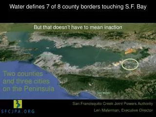
W ater defines 7 of 8 county borders touching S.F. Bay Addressing Sea Level Rise is a shared responsibility . But that doesn ’ t have to mean inaction. Two counties and three cities on the Peninsula . San Francisquito Creek Joint Powers Authority Len Materman, Executive Director.

E N D
Water defines 7 of 8 county borders touching S.F. Bay Addressing Sea Level Rise is a shared responsibility But that doesn’t have to mean inaction Two counties and three cities on the Peninsula San Francisquito Creek Joint Powers Authority Len Materman, Executive Director
Watershed Stanford San Francisquito Creek Palo Alto 50 square miles; two counties; six towns; local, state, & national parks sites; major rail &highways, a regional airport, Postal Service facility, and major research university Menlo Park East Palo Alto Floodplain
Floodplains in Menlo Park, East Palo Alto and Palo Alto Redwood City S.F. Bay East Palo Alto Menlo Park Approximate number of parcels in the 100-year floodplains = creek floodplain only (3,500 parcels) Palo Alto = Bay floodplain only (2,700 parcels) = both floodplains simultaneously (2,200 parcels) 1 mile Mt. View
Protecting people and property from San Francisco Bay to Highway 101 Design objective: 100-year creek flow, 50 years (26”) of SLR, 100-year tide, and 3’ of freeboard • Protects over 1,000 parcels from creek flows and tides exiting channel • Creates 14 acres of new marsh habitat • Enables new golf course and trails • Enables flood protection work upstream • Provides new, safer PG&E gas pipeline East Palo Alto Floodwalls Levees Palo Alto Allows for a restored connection between creek & marshland
Strategy to Advance Flood protection, Ecosystems and Recreation along the Bay SAFER Bay Palo Alto Menlo Park East Palo Alto Ravenswood Ponds Potential horizontal levees with upland transition zone Funders State of CA Cities of East Palo Alto and Menlo Park Facebook, Inc. U.S. Fish & Wildlife Service 30” of SLR with a 100-year Bay tide N Creek 100-year floodplain overlapped with Bay floodplain