Download
1 / 15
150 likes | 300 Vues
Examining a Knowledge Domain: Interactive Visualization of the Geographic Information Science and Technology Body of Knowledge 1. Project Overview by Marilyn Stowell , Masters Student, SDSU Geography. GIS&T Body of Knowledge. Content designed by experts in the field (UCGIS)

E N D
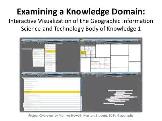
Examining a Knowledge Domain: Interactive Visualization of the Geographic Information Science and Technology Body of Knowledge 1 Project Overview by Marilyn Stowell, Masters Student, SDSU Geography
GIS&T Body of Knowledge • Content designed by experts in the field (UCGIS) • Intended for academic and professional use (course planning, professional certifications, human resources) • Published by the Association of American Geographers
GIS&T Body of Knowledge • Body of Knowledge • Knowledge Areas • Knowledge Units • Knowledge Topics • Learning Objectives
BoK Visualization (BoKVis) Objectives: • Create interactive visualizations which will improve accessibility and understanding of BoK1: • Layout the hierarchical (tree) structure • Break up the tree structure and layout the BoK based on its content • Compare Spatial Layouts, User Testing • Utilize these visualizations as base maps for which other knowledge artifacts can be overlaid. (i.e. curricula, proficiencies, resumes)
Structure-based Visualization of BoK1: Tree Graph Tree Map XML Indented List
Content-based Visualization of BoK1: Dimensionality Reduction (MDS/SOM) Export Similarity Matrix XML XML Similarity Graph
BoK2 Conceptual Model • Hunter College: Ontology • SDSU: Visualization • BYU: Wiki • New Mexico State: VPE