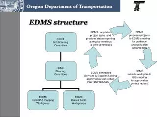
EDMS structure
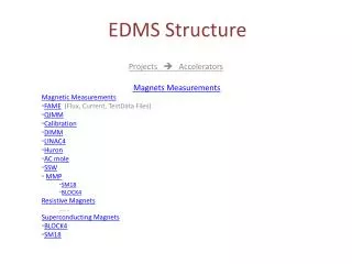
EDMS structure. GPS field applications Wetlands delineation & mitigation monitoring Biology mitigation monitoring Special Management Areas Archaeological site evaluation. GIS web applications EDMS web RES/RAZ map access Environmental Screening Wetlands. EDMS Tools & Data.

EDMS structure
E N D
Presentation Transcript
GPS field applications Wetlands delineation & mitigation monitoring Biology mitigation monitoring Special Management Areas Archaeological site evaluation GIS web applications EDMS web RES/RAZ map access Environmental Screening Wetlands EDMS Tools & Data EDMS standard data • LiDAR and airphotos • ODOT ITIS TransInfo • ODOT SR-SAM • ODOT GES/Region GPS • ODOT SMA • ODOT DFMS • ORNHIC • ODFW • SHPO (secure) GIS desktop • Archaeology (secure)
Internal / External geographic environmental data ODOT GIS Enterprise Data • RES Maps • RAZ Workshops • RAZ Maps Business process driven tools Field GPS tools Desktop GIS tools Web GIS tools EDMS process diagram
GIS 31 Deliverables Updated EDMS Strategic Plan: • Program conceptual model • Program governance structure • EDMS Steering Committee Charter • Documented work approval process • EDMS Program annual work plan Completed items from current work plan: • RES/RAZ product redesign (maps) • Standardized Environmental GIS data (data) • Field data collection tools (GPS) • No effects screening tool (web) • Wetlands data screening tool (web) • Archaeology data access facilitation (secure desktop) • Anadromous Fish Habitat Distribution Data (data) • FHWA Peer Exchange (communications)
EDMS Activities – FY09-11 • MAPPING • GIS DATA COLLABORATION • GPS DATA COLLECTION • WEB APPLICATION DEVELOPMENT • OUTREACH
ODOT EDMS deliverables – FY09-11 • Revised RES/RAZ map products statewide • Region Special Management Area (SMA) maps statewide • Requested Region and Geo-environmental project maps • Quarterly updated Oregon Natural Heritage Program dataset • Statewide Fish Habitat Distribution dataset • Statewide revised State Historic Preservation Office dataset • Statewide Imagery including populated areas LiDAR datasets • Revised GPS data collection tools for mitigation monitoring, delineations and archaeology • Geo-environmental and Maintenance GPS applications for project scoping, botanical and aquatic resources, Special Management Areas and resource protection Revised GIS web interface to RES/RAZ map and information, natural resource screening, wetlands screening, and archaeological Gov-to-Gov tools • New GIS web interface for fish passage, environmental coordination, baseline reporting integration; and minor customer requested minor modifications to interface • In-person and distance-delivered reports, discussion and correspondence • Environmental GIS User Training on ODOT developed applications and supported datasets • Annual report on Environmental GIS use, support and program activities