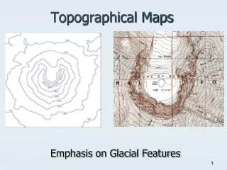
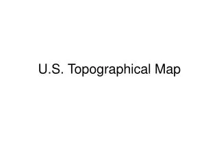
U.S. Topographical Map
Explore the detailed U.S. topographical map showcasing significant rivers such as the St. Lawrence, Mississippi, and Colorado, alongside prominent mountain ranges including the Rocky Mountains, Sierra Nevada, and Appalachian Mountains. This map highlights key geographical features like the Great Basin, Death Valley, and Central Plains, offering a thorough representation of the diverse American landscape. Key peaks such as Mt. Whitney and Mt. McKinley (Denali) are also marked, making this an essential resource for geography enthusiasts and outdoor explorers.

U.S. Topographical Map
E N D
Presentation Transcript
Rivers #20 #29 #22. #25 #23 #24 #21 #27 #26 #28 #30.
Mountains & Plateaus 31 35 32 #30 34 ^ Mt. Whitney 33 ^ Mt. McKinley 36
Plains 41 40 38 39
Deserts 43 42
Rivers St. Lawrence R. Columbia R. Hudson R. Missouri R. Potomac R. Mississippi R. Ohio R. Colorado R. Arkansas R. Rio Grande R. Yukon R.
Mountains & Plateaus Adirondack Mts. Cascade Mts. Rocky Mts. Appalachian Mts. Sierra Nevada Mts. ^ Mt. Whitney ^ Pike’s Peak ^ Mt. McKinley Alaskan Range
Plains GreatBasin Central Plains Atlantic Coastal Plains Gulf Coastal Plains
Deserts Death Valley Mohave Desert
Completed Map St. Lawrence R. Columbia R. Adirondack Mts. Cascade Mts. Hudson R. Missouri R. Rocky Mts. Great Basin Potomac R. Cumberland Plateau Great Salt Lake Mississippi R. Chesapeake Bay Central Plains Appalachian Mts. Sierra Nevada Mts. ^ Mt. Whitney Ohio R. Colorado R. ^ Pike’s Peak Death Valley Atlantic Coastal Plains Arkansas R. Mohave Desert Gulf Coastal Plains LakeOkeechobee Rio Grande R. Yukon R. ^ Mt. McKinley Alaskan Range