Download
1 / 15
170 likes | 449 Vues
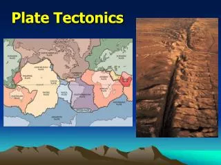
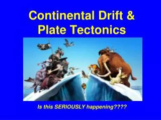
Continental Drift & Plate Tectonics. Is this SERIOUSLY happening????. http://www.uwsp.edu/geo/faculty/ozsvath/images/continental%20fit.jpg. If you take a look at a globe, you can see that if we were to squish the land all together, most of the continents seem to fit together like a puzzle.

E N D
Continental Drift & Plate Tectonics Is this SERIOUSLY happening????
http://www.uwsp.edu/geo/faculty/ozsvath/images/continental%20fit.jpghttp://www.uwsp.edu/geo/faculty/ozsvath/images/continental%20fit.jpg If you take a look at a globe, you can see that if we were to squish the land all together, most of the continents seem to fit together like a puzzle. For example, the west African coastline seems to snuggle nicely into the east coast of South America and the Caribbean sea.
http://www.awi-bremerhaven.de/AWI/Presse/PM/pm05-1.hj/pics/Wegener-w.jpghttp://www.awi-bremerhaven.de/AWI/Presse/PM/pm05-1.hj/pics/Wegener-w.jpg • In 1915 Alfred Wegener proposed: • all the continents were once all one in a single massive continent called Pangaea (meaning "all lands") • over time they drifted apart to their current spots • Pangaea was intact until about 300 million years ago, then began to break up Wegener was a German meteorologist who also was an explorer in Greenland. He died there in his tent while travelling to relieve a group of scientists who were without enough food.
Pangaea: approximately 300 million years ago http://www.ocean.washington.edu/education/magic/images/pangea1.gif
Making Connections: Canada’s Geography. Clark & Wallace. Prentice Hall Ginn, 1999. Wegener had four main pieces of evidence (or reasons why he believed his theory was true): 1. The jigsaw fit of the continents, especially South America and Africa
2. If we go far enough back in our fossil records, we find fossilsthat are the same on both sides of the Atlantic Eventually, the fossils start to differ from each other, suggesting they were geographically separated. Making Connections: Canada’s Geography. Clark & Wallace. Prentice Hall Ginn, 1999.
Making Connections: Canada’s Geography. Clark & Wallace. Prentice Hall Ginn, 1999. 3. Geologic evidence: mountains have the same age and structure on both sides of Atlantic
4. Ice sheets covered parts of Africa, India, Australia and South America 250 million years ago. How could this happen in places that are so warm today? India? Glaciated??!! Huh?! Making Connections: Canada’s Geography. Clark & Wallace. Pearson, 1999.
Click on this link to see a great animation of the spreading of the Atlantic Ocean. http://earthref.org/cgi-bin/z-download.cgi?database_name=erda&search_start=advanced&h=html-header&file_path=/projects/earthref/archive/archive/aaab/m00002.i1.2.seafloor.spreading.swf
Things That Make You Go..hmmm So, Wegener's idea of continental drift made SENSE butwas missing an explanation of how the continents could drift across the earth's surface. He knew they moved, but could never prove HOW they moved!
It wasn’t until the 1960s that the theory of plate tectonicswas advanced to explain how the continents could separate. • A Canadian by the name of • J. TuzoWilson played an important part in the development of this theory.
http://www.psych.utoronto.ca/~rci/graphics/Tuzo_Wilson.jpg • Companion of the Order of Canada. • First Director General of the Ontario Science Centre.
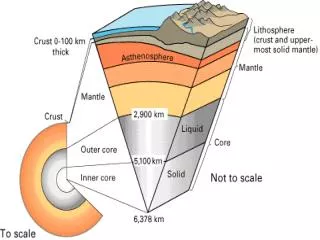
Remember THIS diagram?? It was Wilson who came up with the Theory of Plate Tectonics that the plates are floating on the mantle (magma) and different convection currents moves the plates around (think boiling water moving the lid...)
Continental crust http://geog.ouc.bc.ca/physgeog/contents/10i.html Convection currents power the plate movements. They rise up from the radioactive core, carrying heat to the thin crust of the earth.
Crust is created Crust is “destroyed” Plate Tectonics http://geothermal.marin.org/GEOpresentation/images/img007.jpg