NATIONAL LEVEE DATABASE
The National Levee Database (NLD) is an authoritative resource providing detailed information on the location, condition, and potential impact of levees across the United States. Established under SEC. 9004, it aims to inventory federal and non-federal levees, assess their conditions, and estimate the population and structures at risk in case of failures. Created through collaboration between USACE and FEMA, the NLD supports stakeholders with tools for data management, reporting, and risk assessment, striving for a comprehensive overview of levee safety nationwide.

NATIONAL LEVEE DATABASE
E N D
Presentation Transcript
NATIONAL LEVEE DATABASE INVENTORY/INFORMATION PROGRAM
National Levee Database Defined • “Authoritative Database that Describes the Location and Condition of the Nation’s Levees, and the Potential Consequence Behind Those Levees”
Authorities • 2007 • “SEC. 9004. INVENTORY AND INSPECTION OF LEVEES. • (a) LEVEE DATABASE.— (1) IN GENERAL.—Not later than one year after the date of enactment of this Act, the Secretary shall establish and maintain a database with an inventory of the Nation’s levees. (2) CONTENTS.—The database shall include— • (A) location information of all Federal levees in the Nation (including global information system information) and, for non-Federal levees, such information on levee location as is provided to the Secretary by State and local governmental agencies; • (B) utilizing such information as is available, the general condition of each levee; and • (C) an estimate of the number of structures and population at risk and protected by each levee that would be adversely impacted if the levee fails or water levels exceed the height of the levee.
WRDA, LEVEE SAFETY PRINCIPLES, OBJECTIVES AND NLD • The National Levee Database was initially designed between USACE and FEMA • Common Theme: • Create a database • Obtain inventory and relevant information on all levees in the United States • Create program to communicate levee information to stakeholders • Basic Components of NLD Program • Database • Inventory/Information (inputs) • Inventory/Information Applications (outputs)
NLD Inventory/Information Overview Public NLD Web Site USACE Database NLD Levee Screening FEMA MLI Database Levee Management Census Tool Web Input OGC Web Services Future Integrated Data Bases
Database Components NLD 250 Attributes 18 geospatial figures media 10 non graphic tables
INVENTORY /INFORMATION INTO NLD Levee Inspection System USACE Database Levee Inventory Tool NLD FEMA MLI Database Federal State Tribe Census Tool Web Input Integrated Data Bases
SDSFIE Levee Data Model Features floodwall_line flood_fight_point closure_structure_line rehabilitation_line levee_failure_point levee_crossing_point pump_station_point toe_drain_line levee_centerline sand_boil_point piezometer_point cross_section_line borehole_point leveed_area levee_station_point gravity_drain_line encroachment_point levee_relief_well_point
NLD INVENTORY/INFORMATIONCensus Tool • Current State • Developed as a tool to allow external stakeholders the ability to contribute and manage their levee data to establish a comprehensive levee inventory • Target State • Real-time data integration with NLD • Allow users to import levee data from existing data sets (e.g., .shp, excel, and PGDB files) • Provide auditing and change management capability for user submissions • Standardized review/approval process • Complete comprehensive levee inventory • Target Completion Date August 2011
NLD INVENTORY/INFORMATION USACE • Levee Inventory Tool • Tool used by USACE Districts • USACE Progress to date: • Known miles today = 14648.65 • Miles Completed = 12099.73 = 83% • Miles under contract = 2274.5 = 16% • Waiting contract award = 287.42 = 2%
Public NLD Web Site Reports NLD APPLICATIONS Maps Levee Screening Relative Risk Tool NLD Information Levee Management Emergency Management Water Management OGC Services IndustryStandards Common Future MobileApps
NLD ApplicationsPublic View – Information, Reports, Maps • Allows stakeholders ability to view and run various reports, maps and access other information. • Levee within certain state, city, county
NLD Applications • OGC Web Services • complies with open standards for geospatial data exchange. • Water Management Applications • information useful for water management including levee height, water gages, and real time weather information • Levee Screening Process • Tool used to assess relative risk and other important information concerning levees
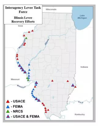
NLD ApplicationsUSACE Kansas City DistrictEmergency Management • Kansas City Flood Fight June 2010 • NLD Served(s) as the ‘One-Stop’ data source for all federal and non-federal levee information • Maps and reports produced using NLD data were exported from the local system (CorpsMap + Sharepoint) to Google Earth for distribution throughout USACE and to external emergency management agencies such as Missouri SEMA
NLD in Google Earth Click the Corps Logo for links to all CMT maps and reports Levee damage points Lake status NWK Civil Boundary The map information is exported from CorpsMap to Google Earth just prior to the CMT briefing. Links to all information are included, such as the CMT briefing packet and photos of field conditions. All necessary files are managed on Sharepoint for internal USACE use. In June 2010 FTP was used to provide all information to EMAs, but in the future NWK will use a Sharepoint Extranet.
Dry Creek Rancheria with Leveed Areas Levee Data Source: National Levee Database Tribal Land Source: US Census Bureau 2000 Indian Land Leveed Area
Colusa Indian Community with Leveed Areas Levee Data Source: National Levee Database Tribal Land Source: Data from US Census Bureau 2000 Indian Land Leveed Area
Seminole Lands with Leveed Areas Levee Data Source: National Levee Database Tribal Land Source: Data from US Census Bureau 2000 Indian Land Leveed Area
Moving Forward… • NLD Public View • Census Tool • Steering Committee Leadership/Meeting • FEMA MLI Data • California Database Information • Next steps: • Other Federal Agencies • Coordinate with Tribes • Coordinate with State Agencies
QUESTIONS/COMMENTS • Contact Information: • Cathi Sanders or Bryan Baker • NLD Project Managers Catherine.R.Sanders@usace.army.mil Byran.E.Baker@usace.army.mil
Some Helpful Feedback Today • How concerned are you or the tribes you represent about levees? • Are there other organizations or tribes you think might be interested in hearing about the Committee or levees? • Any thoughts about emergency management programs we might look to that are good examples of how to involve tribes?
Data fields slide/minimum requirements • Leveed Area (Polygon) • Leveed Area Name • System Name • Number of Segments in System • Segment Name • Authorization Type • Sponsor (Name, Type, …) • Segment(s) length(s)
NLD INVENTORY/INFORMATIONNLD Data Fields For Information Use