Download
1 / 10
100 likes | 414 Vues
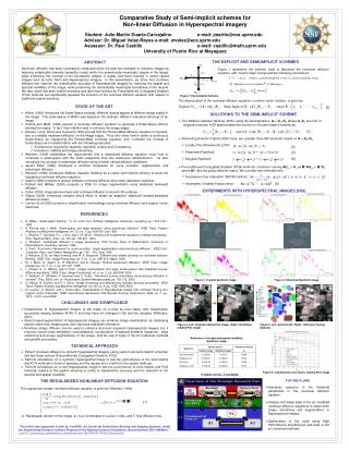
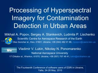
Processing of Hyperspectral Imagery for Contamination Detection in Urban Areas. Mikhail A. Popov, Sergey A. Stankevich, Ludmila P. Lischenko Scientific Centre for Aerospace Research of the Earth 55-B Oles Gonchar st ., Kiev, 01601, Ukraine, +38 (044) 482 01 66, mpopov @casre.kiev.ua

E N D
Processing of Hyperspectral Imagery for Contamination Detection in Urban Areas Mikhail A. Popov, Sergey A. Stankevich, Ludmila P. Lischenko Scientific Centre for Aerospace Research of the Earth 55-B Oles Gonchar st., Kiev, 01601, Ukraine, +38 (044) 482 01 66, mpopov@casre.kiev.ua Vladimir V. Lukin, Nikolay N. Ponomarenko National Aerospace University 17 Chkalov st., Kharkov, 61070, Ukraine, +38 (057) 707 48 41, lukin@ai.kharkov.ua The Fourteenth Conference of software users of ESRI in Ukraine, Yalta, 24-28 May, 2010
Scientific Centre for Aerospace Research of the Earth Geochemical contamination map of Kiev The Fourteenth Conference of software users of ESRI in Ukraine, Yalta, 24-28 May, 2010
Scientific Centre for Aerospace Research of the Earth D(λ) 4r2(λ) C(λ) = log2[1+ψ(λ)] Hyperspectral imagery informativity D(λ) – Kullback-Leibler divergence, r(λ) – equivalent spatial resolution , ψ(λ) – equivalent SNR Optimal bands selection λ* : C(λ*) → max Pseudogradient search λ0 := 1T λi := λi-1+ ∆λ grad C(λi-1) grad C(λ*) ≤ 0 The Fourteenth Conference of software users of ESRI in Ukraine, Yalta, 24-28 May, 2010
Processing dataflow Scientific Centre for Aerospace Research of the Earth From airborne / speceborne imaging systems T o u s e r s a n d c u s t o m e r s The Fourteenth Conference of software users of ESRI in Ukraine, Yalta, 24-28 May, 2010
Hyperspectral imagery classification Scientific Centre for Aerospace Research of the Earth ∂ρ(λ) ∂λ P(ρ) = Pr ∫|sign[∆ρ(λ), ε(λ)]| dλ + ∫|sign[∆ , ε(λ)]| dλ P(ρ) – spectral-topological metric, ∆ρ(λ) – spectral difference, ε(λ) – statistical confidence Bayesian decision rule P(x|A) P(x|A)+P(x|B) if x “open natural lands” 0 otherwise P(x) = P(x) – contamination level, P(x|A) – conditional probability of membership of the x pixel signal in contaminated site reference sample A, P(x|B) – conditional probability of membership of the x pixel signal in non-contaminated area reference sample B The Fourteenth Conference of software users of ESRI in Ukraine, Yalta, 24-28 May, 2010
Classification software Scientific Centre for Aerospace Research of the Earth ClassGeo-M hyperspectral imagery spectral-topological classification software Project/ROI module Supervised classification module The Fourteenth Conference of software users of ESRI in Ukraine, Yalta, 24-28 May, 2010
Geochemical contaminations mapping Scientific Centre for Aerospace Research of the Earth abcd a – EO-1/Hyperion hyperspectral satellite image, September 1, 2002, spectral bands 115 (1296 nm), 95 (1094 nm), 36 (712 nm), 30 m spatial resolution; b – land cover classification; c – open surfaces separation using OBIA between open artificial areas and open natural lands; d – contaminations spatial distribution for an “open natural lands” class The Fourteenth Conference of software users of ESRI in Ukraine, Yalta, 24-28 May, 2010
Contamination data validation Scientific Centre for Aerospace Research of the Earth The Fourteenth Conference of software users of ESRI in Ukraine, Yalta, 24-28 May, 2010
Hyperspectral data compression Scientific Centre for Aerospace Research of the Earth abc EO-1/Hyperion spectral bands 14 (488 nm), 22 (569 nm), 26 (610 nm), 32 (671 nm)) before (a) and after (b) 9.6 times lossy compression; c – the pixel deviations histogram of the compressed image The Fourteenth Conference of software users of ESRI in Ukraine, Yalta, 24-28 May, 2010
References Scientific Centre for Aerospace Research of the Earth • Popov M A, Stankevich S A, Lischenko L P, Podorvan V N (2007) Mapping of technogenic contaminations of urban area using hyperspectral imagery. Thesis of Polish-Ukrainian Workshop on Space Applications, Warsaw (Poland) • Stankevich S A (2006) Quantitative estimation of hyperspectral aerospace imagery informativity for the remote sensing thematic tasks (Ukrainian). Proceedings of NAS of Ukraine, 10:136-139 • Stankevich S A (2007) Hyperspectral aerospace imagery spectral bands optimal selection for the remote sensing thematic tasks (Russian). Space Science & Technology, 13(2):25-28 • Lukin V V (2009) Processing of multichannel RS data for environment monitoring. Proceedings of NATO Advanced Research Workshop on Geographical Information Processing and Visual Analytics for Environmental Security, Trento (Italy) • Lukin V V, Ponomarenko N N, Zelensky A A, Kurekin A A, Lever K (2008) Compression and classification of noisy multichannel remote sensing images. Proceedings of XIV SPIE Conference on Image and Signal Processing for Remote Sensing, Cardiff (UK) • Lukin V V, Ponomarenko N N, Zriakhov M S, Krivenko S S, Zelensky A A, Popov M A, Stankevich S A, Kovalchuk S P, Titarenko O V (2009) Methods for remote sensing hyperspectral imagery processing and compression (Russian). Proceedings of 8th International Conference “Modern Information Technologies in Ecological Security, Natural Resources and Disasters Management”, Rybachie (Ukraine) • Ponomarenko N N, Krivenko S S, Lukin V V, Egiazarian K O (2009) Visual quality of lossy compressed images. Proceedings of 10th International Conference “The Experience of Designing and Application of CAD Systems in Microelectronics” CADSM’2009, Svalyava (Ukraine) • Ponomarenko N N, Lukin V V, Egiazarian K O, Astola J T (2010) A method for blind estimation of spatially correlated noise characteristics. Proceedings of SPIE, 7532:3208 The Fourteenth Conference of software users of ESRI in Ukraine, Yalta, 24-28 May, 2010