Understanding GPS Fundamentals - Your Location Coordinates
190 likes | 301 Vues
Learn about the Global Positioning System (GPS), satellite signal structure, code modulation, autonomous positioning, and measurement precision using GPS observables. Understand GPS errors and requirements for accurate positioning.

Understanding GPS Fundamentals - Your Location Coordinates
E N D
Presentation Transcript
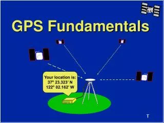
GPS Fundamentals Your location is: 37o 23.323’ N 122o 02.162’ W
Global Positioning System Your location is: 37o 23.323’ N 122o 02.162’ W
Satellite Signal Structure Carrier L1 L2 Frequency 1575.42 MHz 1227.60 MHz Wavelength 19cm 24cm Code Modulation C/A-code - P(Y)-code P(Y)-code NAVDATA NAVDATA C/A - Coarse Acquisition Code P - Precise Code (Y-Code when encrypted) NAVDATA - Satellite health, satellite clock corrections, and ephemeris parameters.
Autonomous Position Relative Position What is Measured? GPS Observables Code Ranges Carrier Phases
Code Range Results Autonomous Position +/- 100 m (330 ft) error (horizontal) +/- 156 m (515 ft) error (vertical)
Measured Reduced D X = -408.251 m D Y = -84.830 m D Z = -369.413 m OR Carrier Phase Results Baseline or Vector (cm precision) Azi = 212o 42’ 49.8244” Dist = 557.05307 m DEll Ht = 4 .8751 m
+Z Z Y X -Y +X ECEF Coordinate System ECEF X = -2691542.5437 m Y = -4301026.4260 m Z = 3851926.3688 m
a = semi-major axis b = semi-minor axis b b a a Reference Ellipsoid H f WGS-84 Ellipsoid a = 6378137.000000 m b = 6356752.314245 m 1/f = 298.2572235630 l
+Z H b Z f Y X a l -Y +X ECEF and WGS-84 ECEF X = -2691542.5437 m Y = -4301026.4260 m Z = 3851926.3688 m WGS-84 f = 37o 23’ 26.38035” N l = 122o 02’ 16.62574” W H = -5.4083 m
GPS Heights vs. Elevations Earth’s Surface H H h h H h N Ellipsoid N N Geoid h = Orthometric Height H = Ellipsoid Height N = Geoid Height h = H - N
Errors Sources in GPS • Selective Availability (SA) and Anti-Spoofing (AS) • Multipath • Ionospheric Noise • Human Error
SA and AS • Selective Availability (SA) • Clock dither • Ephemeris error • Anti-Spoofing (AS) • Encryption of the P-code signal ???????? 100 meters
Ionospheric Effects Ionosphere > 10 km < 10 km
10:35 10:30 Survey Requirements
Summary • There are three segments to GPS. All must be working to use GPS. • There are 2 GPS signals, L1 and L2. • Code Range measurements result in autonomous positions with several meter precision. • Carrier Phase measurements result in relative positions with centimeter precision.
Summary (cont.) • GPS results are in reference to an ECEF coordinate system and the WGS-84 ellipsoid. • Errors in GPS can be minimized by planning and utilizing proper surveying techniques. • At least 4 SVs are required to determine a position or survey with GPS. • At least 2 receivers are required to survey with GPS.