Download
1 / 80
800 likes | 884 Vues
Gain insights into oceanography from longitudes to plate boundaries. Discover the Earth's geological history, sea floor spreading, continental drift, and more.

E N D
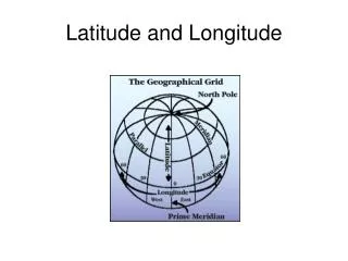
2. The determination of longitude is mainly a function of ? • 1) geometry • 2) latitude • 3) distance • 4) time
3. The North Pole is an __? • Ice-covered ocean • Ice-covered land • Ice-free ocean • Ice-free land
4. Equipment commonly used in oceanography today include ? • 1) ships • 2) all of these • 3) satellites • 4) submersibles
5. An early chart of the Gulf Stream was done by ___? • 1. Ben Franklin • 2. Charles Darwin • 3.Eratosthenes • 4. Alfred Wegner
Which ocean is largest? • 1. The Atlantic Ocean • 2. The Indian Ocean • 3. The Pacific Ocean • 4. The Gulf of Mexico
3. Earth is the ___planet from the sun. • 1) second • 2) third • 3) fourth • 4) fifth
4. Absolute age dating is based on ___. • 1) radioactive isotope decay • 2) sedimentary layers • 3) the amount of oxygen • 4) chemical composition
5. Impact craters are hard to find on earth because ___. • 1) we haven’t been hit often • 2) Jupiter attracts all objects • 3) the craters erode over time • 4) all objects burn up in the atmosphere
6. Free atmospheric oxygen in amounts similar to today was not present for about the first 60% of the earth's history because of what? 1. most of it was initially used up in chemical reactions 2. the earth was too hot 3. photosynthetic plants have existed for only the last million years 4. the composition of seawater has only remained relatively constant for the last 600 million years
1. Which layer of the earth is rigid? • 1) the asthenosphere • 2) the core • 3) the mantle • 4) the lithosphere
3. When glaciers are formed on a land mass, what happens to its average water line? • 1) it is further offshore • 2) it remains the same • 3) it is further inland • 4) there is no way to predict
3. When glaciers are formed on a land mass, what happens to its average water line? • 3) it is further inland
4. The density of a substance determines whether it will sink or float on another substance. The units we use for density are ___. 1. gms 2. gms/cm2 3. gms/cm3
6. A rock that is an example of oceanic crust is ____ . • 1. Granite • 2. Shale • 3. Fossilized bones • 4. Basalt
1. Early evidence suggesting continental drift include all of the following except ___. • 1) fit of continents • 2) observations of vulcanism on the sea floor • 3) similarity of fossils • 4) similarity of rock formations
2. Spreading rates of major plates are about ___. • 1) < 1cm/year • 2) 2-10cm/year • 3) 10-50cm/year • 4) >100cm/year
3. The Nazca Plate is moving roughly ____. • 1) north • 2) south • 3) east • 4) west
4. The Hawaiian Islands have formed from ___. • 1) a mid-ocean ridge system • 2) coral reefs • 3) a hot spot • 4) erosion of a continent
5. The magnetic striping of the seafloor is considered evidence of seafloor spreading and ____. 1) spreading centers in the trenches. 2) changes in the Earth's axis of rotation. 3) periodic reversals in the polarity of the Earth's magnetic field. 4) periodic collapses of the Earth's gravitational field.
3) periodic reversals in the polarity of the Earth's magnetic field.
6. The mid-ocean ridges are recognized as: • 1) subduction zones. • 2) transform or lateral plate boundaries. • 3) divergent plate boundaries. • 4) convergent plate boundaries.
7. A prominent feature of a continental-continental plate boundary is/are ___. • 1) a trench • 2) a rift valley • 3) mountains • 4) volcanoes
1.Passive continental margins occur ______. 1) at subduction zones 2) along the US East Coast 3) at mid-ocean spreading centers 4) near hot spots
2. The region of the continental margin closest to the beach is ____. 1) the continental shelf 2) the shelf break 3) the continental slope 4) the continental rise
3.Turbidity currents are _____. 1) underwater landslides 2) currents that produce turbidites 3) fast-moving sediment slurries 4) all of these
4.The bottom on abyssal plains are very flat because ____. 1) they are eroded by turbidity currents 2) most irregular topography is covered by sediments 3) the basalt flattened before it solidified 4) we have no idea
5.All of the following are features of mid-ocean ridges except ____. 1) irregular topography 2) rift valleys 3) trenches 4) hydrothermal vents