Download
1 / 40
400 likes | 520 Vues
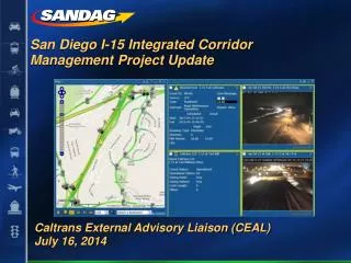
Summary of Recent Integrated Corridor Management (ICM) Development Efforts in the United States. François Dion, PhD fdion@path.berkeley.edu. May 28, 2013. Summary of ICM Efforts. I-15 San Diego. Corridor. 21-mile section of I-15, north of San Diego Key transportation networks I-15 freeway

E N D
Summary of Recent Integrated Corridor Management (ICM) Development Efforts in the United States François Dion, PhD fdion@path.berkeley.edu May 28, 2013
Corridor • 21-mile section of I-15, north of San Diego • Key transportation networks • I-15 freeway • Parallel arterials • Center City Parkway (in Escondido) • Pomerado Road (in Poway and San Diego) • Black Mountain Road/ Kearny Villa Road (in San Diego) • Transit services • MTS bus network • NCTD bus network • NCTD Sprinter Commuter Rail
Partnering Agencies • US Department of Transportation • Research and Innovation Technology Administration (RITA) • Federal Highway Administration (FHWA) • Federal Transit Administration (FTA) • State agencies • Caltrans, District 7 • California Highway Patrol (CHP) • Freeway Service Patrol • Regional agencies • San Diego Association of Governments (SANDAG) • Transit agencies • San Diego Metropolitan Transit System (MTS) • North County Transit District (NCTD) • Local cities • San Diego, Poway, Escondido • Technical support • Kimley-Horn • Delcan • Transport Simulation Systems (TSS) • University of California, Berkeley • Cambridge Systematics • Batelle • Volpe Center
ICM Goals • Improve accessibility to travel options and attain an enhanced level of mobility • Enhance corridor safety • Provide travelers with informational tools enabling them to make smart travel choices within the corridor • Promote coordination among institutional partners • Manage the corridor holistically under both normal operating and incident/event conditions in a collaborative and coordinated way
Strategies Considered • System monitoring/data sharing • Real-time freeway and arterial traffic monitoring • Real-time bus transit monitoring • Real-time traffic signal operations monitoring • Weather monitoring • Freeway operations • Traffic-responsive ramp metering • Lane configuration on I-15 managed lane system • Access policy to I-15 managed lane system • Arterial operations • Traffic-responsive signal operation • Freeway ramp/arterial traffic signal coordination
Strategies Considered • Transit operations • Rerouting of transit vehicles around incidents • Increases in transit service in response to event/incidents • Traveler information • Integrated, multi-modal traveler information service • Provision of comparative travel times along alternate routes • Provision of real-time park-and-ride space availability information on freeways and approach routes • Incident/event management • Simulation-based evaluation (microscopic modeling) of potential traffic management alternatives
Corridor • 20-mile section of the US-75 freeway northeast of downtown Dallas • Freeways • US-75 freeway, with managed HOV lanes • Parallel arterials • Freeway frontage roads • Greenville Avenue • Coit Road • Transit services • DART Bus Network • DART Light Rail
Partnering Agencies • US Department of Transportation • Research and Innovation Technology Administration (RITA) • Federal Highway Administration (FHWA) • Federal Transit Administration (FTA) • State agencies • Texas Department of Transportation, Dallas & Fort Worth Districts • Regional agencies • North Central Texas Council of Governments (NCTCOG) • North Texas Tollway Authority (NTTA) • Fort Worth Transportation Authority • Dallas Regional Mobility Coalition • Transit agencies • Dallas Area Rapid Transit (DART) • Airports • Dallas/Fort Worth International Airport • Local cities • Dallas, Plano, Richardson, Highland Park, University Park • Technical support • Telvent • Texas Transportation Institute (TTI) • Southern Methodist University (SMU) • University of Texas at Arlington • Cambridge Systematics • Batelle
ICM Goals • Increase corridor throughput • Improve travel time reliability • Improve incident management • Enable intermodal travel decisions
Strategies Considered • System monitoring/data sharing • Regional information exchange network (SmartNET) • Bluetooth traffic monitoring along freeway and two diversion routes (40 locations, typically spaced 1-2 miles) • Real-time monitoring of light rail location and passenger count • Weather monitoring • Freeway operations • Predefined diversion plans to local arterials and/or light-rail service in response to incidents • HOV/HOT Lane Management • Arterial operations • New signal timing plans for Greenville Avenue • Development of event-specific signal timing plans • Responsive traffic signal control Traffic Detection Plan
Strategies Considered • Traveler information • Multimodal traffic and transit 511 system with interactive voice response system, public web access, and mobile application • Real-time transit vehicle information (vehicle location, time to arrive at next stop) • Publication of parking availability information for 5 park-and-ride lots along the LRT red line on the 511 system and CMS signs • Links to social media (Facebook, Twitter) • Exploration of sponsorship options • Incident/event management • Simulation-based evaluation (mesoscopic modeling) of potential traffic management alternatives
Corridor • 20-miles section of I-80 from Bay Bridge to Carquinez Bridge • Key corridor networks • I-80 freeway • Parallel arterials • San Pablo Avenue • Transit services • BART subway network • AC Transit bus network
Partnering Agencies • State agencies • Caltrans • California Highway Patrol (CHP) • Regional agencies • Metropolitan Transportation Commission (MTC) • Alameda County Transportation Commission • Contra Cost Transportation Authority (CCTA) • West Control Costa Transportation Advisory Committee (WCCTAC) • Transit agencies • AC Transit • WestCAT • Local Cities • Albany, Berkeley, El Cerrito, Emeryville, Hercules, Oakland, Pinole, Richmond, San Pablo
ICM Goals • Provide traffic operation on the corridor that is equitable and balanced for both the freeway and arterials. • Integrate transportation system management activities to enhance safety and mobility for all travel modes • Enhance overall transit travel time during normal operations • Enhance trip reliability by providing consistent and predictable travel times on the freeway and local arterials • Avoid impacts on local arterials while managing access at on-ramps during peak periods on weekdays and weekends • Efficiently guide traffic naturally diverted to local arterials during major freeway incidents back to the freeway • Cooperatively operate, manage and maintain all ICM elements
ICM Goals • Cooperatively develop, implement, evaluate and revise strategies to ensure balanced benefits to local, regional, and inter-regional travelers • Cooperatively identify and address any adverse impacts in a timely fashion • Ensure on-going communication among partnering agencies for timely review and adjustment of activities as needed • Ensure timely and appropriate communication with the public, media, and elected officials • Monitor, evaluate, and report on project performance to ensure compliance with goals and objectives • Facilitate cooperative activities that ensure the sustainability of benefits from the project
Strategies Considered • Freeway operations • Adaptive ramp metering with preferential treatment to HOV vehicles • End of queue warning • Dynamic lane use signals • Variable advisory speed signs • Installation of CCTV cameras • Arterial operations • Traffic signal system upgrade • Signal synchronization/optimization • Traffic detection along San Pablo Avenue • Transit operations • Transit signal priority enhancements at signalized intersections
Strategies Considered • Traveler information • Dynamic information display boards showing transit/traffic information • Trailblazer signs along arterials to help traffic go back to the freeway • Incident Management • Freeway traffic rerouting through parallel arterial • Implementation of traffic signal flush plan to provide additional capacity • Traffic signal preemption for first responders • System integration • Central system to operate all technologies
Corridor • 52-mile section of I-95/I-395 between Spotsylvania Interchange and 14th Street Bridge near Washington DC • Major corridor assets • I-95/I-395 freeway • Transit services • Commuter rail along entire corridor • Various bus services • Park-and-ride • 40,771 spaces within corridor • Ridesharing services • Carpools / Vanpools • 6400 daily “slugs” (2008) • Real-time ridesharing pilot
Partnering Agencies • Federal agencies • Federal Highway Administration (FHWA) • Federal Transit Administration (FTA) • U.S. Department of Defense • State agencies • Virginia Department of Rail and Public Transportation • Virginia Department of Transportation (VDOT) • Maryland State Highway Administration • Transit agencies • Washington Metropolitan Area Transit Authority (WMATA) • Commuter Connections • Virginia Railway Express • Local cities • Alexandria, Fredericksburg
Partnering Agencies • Regional agencies • Metropolitan Washington Council of Governments (MWCOG) • Northern Virginia Regional Commission (NVRC) • Northern Virginia Transportation Commission (NVTC) • Potomac and Rappahannock Transportation Commission (PRTC) • Arlington County • Loudon County • Prince William County • Fairfax County Department of Transportation • Dulles Area Transportation Association • George Washington Regional Commission • Metropolitan Area Transportation Operations Coordination (MATOC) • Universities • University of Maryland Center for Transportation Technology
ICM Goals • Promote different travel options to achieve travel time savings and overall environmental benefits • Reduce travel time and congestion by managing travel demand in real-time • Reduce the economic cost of travel delays and congestion (from commuter, business and freight movement perspectives) • Reduce or eliminate primary or secondary • Specific volume reduction of 1800 vehicles per day on particularly congested days, targeted for travelers to the Mark Center complex in Alexandria
Strategies Considered • System monitoring/data sharing • Integrated single information gateway • Freeway operations • Ramp queue warning • Traffic-responsive ramp metering (some with HOV bypass) • Hard shoulder running • Arterial operations • Traffic signal upgrades (adaptive control along selected arterials) • Transit operations • Transit signal priority for express buses • Traveler information • Real-time park-and-ride space availability information on freeways and approach routes • Comparative travel times along alternate routes (freeway, arterials, transit) • Integrated, multi-modal traveler information service • Incident management • Enhanced incident detection and management
Corridor • 26 mile section of the I-394/US-12 corridor west of Minneapolis • Corridor networks • I-394 freeway, with HOV and HOT lanes • Parallel arterials • Highway 55 • Highway 7 • Three parallel freeway connectors (I-494, Hwy 169, Hwy 100) • Transit services • Metro Transit • Plymouth Transit • SouthWest Transit (commuter services from outside corridor to downtown) • Bicycle network • Network of commuter bicycle routes.
Partnering Agencies • US Department of Transportation • Federal Highway Administration (FHWA) • State agencies • Minnesota Department of Transportation • Minnesota State Patrol • MnPASS Phase 2 Initiative Team • Regional agencies • Metropolitan Council • Hennepin County • Transit agencies • Metro Transit • Plymouth Metrolink • SouthWest Transit • Local jurisdictions • City of Minneapolis • Local Police/Fire Departments
ICM Goals • Maintain mobility and reliability • Reduce the variation in travel times experienced by travelers • Maintain options for travelers to effectively travel using personal vehicles, transit or bicycles. • Maximize corridor-wide capacity utilization • Monitor available capacity of roadways, transit, parking, and alternative transportation options • Encourage pattern changes (through information sharing or incentives) to better utilize spare capacity • Event and incident management • Inform travelers of incidents, their impacts, and available reroute or mode change options • Manage traffic around events through early notification and informed reactions • Holistic traveler information delivery • Make travelers aware of their modal and route options. • Inform travelers of options for avoiding or minimizing the impacts of travel delays
Strategies Considered • System monitoring • Development of automated information exchange capabilities among participating agencies • Develop a corridor data clearinghouse collecting real-time information on incident, infrastructure status, transit schedule adherence, parking availability, travel times along major routes • Freeway operations • Development of alternate ramp metering strategies to address special events and incidents • Dynamic freeway shoulder use during incident or special events • HOV ramp metering bypass • Variable speed limit to maintain steady flow and prevent incidents • Opening HOT lane to all traffic during incidents • Additional CMS along freeway
Strategies Considered • Arterial operations • Adds automated, condition-responsive capability to traffic signals on arterials in the I-270 corridor • Coordinated arterial and ramp metering operations • Development of special signal timing plans to address special events and incidents • Transit operations • Transit signal priority along arterials • Transit connection information display for travelers and drivers • Transit-only lanes on key routes within the City of Minneapolis • Additional transit services during special events • Temporary parking additions through nearby mall or church lots and shuttle buses during events • Transit fare adjustment during special events
Strategies Considered • Parking operations • Parking fee adjustment during special events • Traveler information • Add transit delays/schedule adherence and parking availability information to existing 511 services • Increased deployment of CMS at key arterial street locations to inform travelers of conditions on arterial streets or to warn of incidents on freeways • Increased deployment of ATIS devices in parking garages • Incident management • Integration of metro transit control center with CAD reports of incidents • Payment system • Attempt to combine HOT, parking, and transit payment system
Corridor • 22 mile section of I-270, from the I-495 freeway (Beltway) to the Frederick County line • Major corridor assets • I-270 freeway • Parallel arterials • MD-355 • Network of arterial and connector routes • Transit services • MARC Commuter Rail • WMATA Metrorail systems • WMATA Metrobus network • Ride On local/commuter bus network • MTA Commuter Bus network
Partnering Agencies • US Department of Transportation (USDOT) • Federal Highway Administration (FHWA) • Federal Transit Administration (FTA) • Research and Innovative Technology Administration (RITA) • Maryland State Highway Administration (MDSHA) • Maryland Transit Administration (MTA) • Montgomery County Department of Public Works and Transportation (DPWT) • The University of Maryland (UMD) • Washington Metropolitan Area Transit Authority (WMATA)
ICM Goals • Optimize mobility, reliability, and safety • Strengthen corridor-level decision support • Enhance reliable, real-time information to customers • Promote multi-modalism
Strategies Considered • System monitoring • Enhance capability to measure travel time reliability, delays, incident severity, incident cleanup and recovery times, transit/parking utilization • Prototype and deploy an enhanced Regional Integrated Transportation Information System (RITIS) • Arterial operations • Adds automated, condition-responsive capability to traffic signals on arterials in the I-270 corridor • Traveler information • Deliver computer-aided dispatch/automatic vehicle location (CAD/AVL) status information to transit users • Deliver parking availability information to commuters