
Current Weather in Madison - July 16, 2002
As of 10:00 AM CDT on July 16, 2002, Madison's weather is sunny with a temperature of 79°F (26°C) and a dew point of 60°F (15°C), resulting in a relative humidity of 52%. Winds are from the southwest at 6 MPH, and the barometric pressure is at 30.13 inches (1020.3 mb). Stay updated with local weather conditions, including cloud classifications and types. Today's forecast and important announcements are also included, such as homework deadlines and insights on cloud observations for better understanding of weather phenomena.

Current Weather in Madison - July 16, 2002
E N D
Presentation Transcript
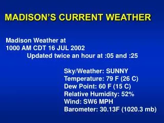
MADISON’S CURRENT WEATHER Madison Weather at 1000 AM CDT 16 JUL 2002 Updated twice an hour at :05 and :25 Sky/Weather: SUNNY Temperature: 79 F (26 C) Dew Point: 60 F (15 C) Relative Humidity: 52% Wind: SW6 MPH Barometer: 30.13F (1020.3 mb)
T.S. Arthur Winds: 60 mph CURRENT VISIBLE
T.S. Arthur CURRENT IR
Current Surface Weather Map with Isobars (“iso” = equal & “bar” = weight), Fronts and Radar
Current Temperatures (°F) & Isotherms(“iso” = equal +”therm” = temperature)
IFR – Instrument Flight RulesRed Dots: Ceiling < 1000 ft or Visibility < 3 miles
Announcements • Homework #3 is due next Thurs. 18 July 2002 • If you have ??, please see me.
ATM OCN 100 - Summer 2002 LECTURE 12 CLOUD OBSERVATIONS & CLASSIFICATION • INTRODUCTION CLOUDS – SIGNPOSTS IN THE SKY • What can be learned from clouds? • Is it partly cloudy or partly sunny? • How are clouds classified?
CLOUDS - SIGNPOSTS IN THE SKY • Atmospheric moisture content; • Air temperatures aloft; • Atmospheric stability; • Tracer for winds aloft (speed & direction) and wind shear[speed/direction change with height].
B. OBSERVATIONAL MEASUREMENTS OF CLOUDS • Cloud Amount or Sky Cover • fraction of sky covered by a cloud; • based on visual estimates or measurements.
B. CLOUD OBSERVATIONS (con’t.) • Cloud Heights & Ceilings • Height of cloud base; • Based upon visual estimates or measurements.
C. CLOUD TYPES - CLOUD CLASSIFICATION SCHEME • Historical • Luke Howard in early 19th century. • Basis for Modern Traditional Cloud Classification Scheme • Appearance • Height
C. CLOUD CLASSIFICATION SCHEME (con’t.) • The Nature of Cloud Types • Layer or Stratiform Clouds • Layer forms indicate gentle uplift. • Heaped or Cumuliform Clouds • Puffy forms indicate vigorous uplift.
CLOUD TYPES [based upon International Cloud Atlas (WMO)]See Table 7.1 Moran & Morgan, 1997
HIGH CLOUDS > 20,000 ft (> 6 km) “Cold clouds” with ice crystalsSee Table 7.1 Moran & Morgan, 1997
Cirrostratus (Cs) Made of a thin, transparent layer of (all ice) high clouds. Halos are common with this cloud type.
Cirrocumulus (Cc) Note the clumpy rows – due to wind shear (also all ice)
MIDDLE CLOUDS 6500 to 20,000 ft (2 – 6 km) “Cold clouds” with supercooled water dropletsSee Table 7.1 Moran & Morgan, 1997
Altocumulus (Ac) Remember…cumulus means puffy. (Can be a mix of ice & water)
Altostratus (As) Another transparent layer….this one is at mid levels and can be made up of ice and water
LOW CLOUDS 0 – 6500 ft (0 – 2 km)“Warm clouds” with water dropletsSee Table 7.1 Moran & Morgan, 1997
Stratocumulus (Sc) (con’t.) Stratocumulus layers are thin, but can be extremely dense, as seen from above.
VERTICALLY DEVELOPED CLOUDS0 – 10,000 ft ( 0 – 3 km)See Table 7.1 Moran & Morgan, 1997
Cumulus (Fair Weather) (Cu) Note the puffiness of the clouds. Also, they are rather isolated, although it may not appear that way on the horizon.
Cumulonimbus (Cb) Approximate tropopause (~ 6 miles high) ANVIL RAIN SHAFT Notice the anvil aloft! This cloud is probably nearly 100 miles away. They are huge!!!