Download
1 / 10
100 likes | 228 Vues
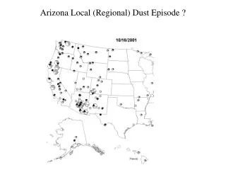
Detailed conditions and forecasts surrounding a significant dust episode in West Texas and the Mid South Region, including wind patterns, sources of haze, and surface conditions.

E N D
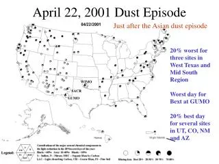
April 22, 2001 Dust Episode Just after the Asian dust episode 20% worst for three sites in West Texas and Mid South Region Worst day for Bext at GUMO 20% best day for several sites in UT, CO, NM and AZ WIMO SACR GUMO
Synoptic Conditions NWS: “Intense upper low and associated surface cyclone pulling away from the area the evening of April 22nd in this map. Expect winds to decouple fairly quickly this evening across all but the ECNTL/NE where a wind advisory will be in effect until 03Z.”
Surface Conditions: AM cold front Dryline
Surface Conditions: PM cold front
Surface Conditions: El Paso The El Paso airport reported blowing dust afternoon and evening of April 21st. Winds gusting between 24 and 36 knots on April 22nd. Low dewpoints-dry air
Surface Conditions: El Paso NEXRAD reports no rain at the West Texas sites by the morning of April 22nd. Flagstaff, Farmington and Front Range stations report light snow in the morning. Forecasted snow at Northern NM upper elevations. Probably snow
5 day West Texas backtrajectories Imply Southern NM and West Texas “local” sources and potential transport from Northern Mexico 12z 12z
Large regional dust sources There are more sources to the east in NM and west Texas not shown on this map GICL SACR GUMO
5 day Oklahoma backtrajectories 18z 12z Site in Moist Gulf air east of dryline Dryline moving eastward 03z 23z Dryline at lower levels only: red is 10m trajectory, warm dry air is aloft to transport air from the west
Causes of haze during the event CM transported from West Texas wind aloft; Sulfates at WIMO from Ohio Valley and sea salt; organics may be from Ohio Valley and low level transport from central Texas WIMO Dust Source CM and FS at GUMP and SACR from sources in NM, TX and Mexico